swmtnbackpacker
Trail Wise!
Back but probably posting soon under my real name ... Rico Sauve
Posts: 4,886
|
Post by swmtnbackpacker on Aug 11, 2015 5:53:25 GMT -8
So, who's going to fine the EPA? Fine them for what? Fine them for trying to clean up someone else's mess that had been polluting the same river for decades? Yup, these mines slowly leach the same metals into the watershed, so that's why the EPA cleans them up (as opposed to just caging and cementing the entrances like drier parts of New Mexico). Some good news is EPA is already considering reopening the upper reaches of the river ... www.durangoherald.com/apps/pbcs.dll/article?aid=/20150810/NEWS01/150819966&template=mobileart&template=mobileart... as the plume makes its way towards AZ's Lake Powell (settling on the bottom with agricultural runoff and other wastes). |
|
swmtnbackpacker
Trail Wise!
Back but probably posting soon under my real name ... Rico Sauve
Posts: 4,886
|
Post by swmtnbackpacker on Aug 11, 2015 7:59:04 GMT -8
The bartender at Ken & Sue's Restaurant makes terrific Perfect Manhattans! This information is provide to enhance your civic duty obligations. Conductor 8.3% imperial ale at Steamboat ...Wow and yeow |
|
|
|
Post by graywolf on Aug 11, 2015 10:27:13 GMT -8
From CNN "Oh my God! Look at the lead!" said Joseph Landolph, a toxicologist at the University of Southern California, pointing to a lead level in the Animas River nearly 12,000 times higher than the acceptable level set by the Environmental Protection Agency.
One of the samples of mercury was nearly 10 times higher than the EPA acceptable levels. Samples of beryllium and cadmium were 33 times higher, and one of the arsenic levels was more than 800 times higher.
I only live one hundred miles from the Animas and San Juan rivers. Am I going to be able to eat Elk meat, or crops grown from the area and what about mosquito bites. Hopefully my well doesn't get contaminated.
|
|
|
|
Post by Lamebeaver on Aug 11, 2015 10:41:33 GMT -8
100 miles is far enough away to avoid well contamination, especially as most of the contaminated water will wash downstream quickly.
As far as elk, I'd say most will find non-contaminated feeder streams to drink out of. Maybe I am wrong and elk aren't that smart, but I'm guessing that water tastes funny.
And I do hope that the people who manage the water were smart enough to shut off the diverters for local irrigation ditches.
Just to putt things in perspective, the EPA max lead for drinking water is 15 parts-per-billion, so the actual level of lead in the Animas was 180 parts per million.
|
|
|
|
Post by graywolf on Aug 11, 2015 10:52:44 GMT -8
I wasn't totally serious with my questions but was trying to make the point that this could effect much more than the rivers. BTW, if the 12,000 times acceptable levels comment is accurate then that would mean the Animas river would be at 180,000 parts per million.
|
|
BlueBear
Trail Wise!
@GoBlueHiker
Posts: 3,224
|
Post by BlueBear on Aug 11, 2015 11:14:05 GMT -8
BTW, if the 12,000 times acceptable levels comment is accurate then that would mean the Animas river would be at 180,000 parts per million. LB had it right, it's 15 parts-per- billion times 12,000, making it approximately 180 PPM. But that's still 0.018% pure lead in floating around in the water (by molecular concentration, considerably more by weight), which is quite a lot, if you consider it. Add that to the arsenic, mercury, cadmium, and other heavy metals, you'd got yourself quite a toxic little cocktail there. Fish don't live in it, humans can't consume it, and it's washing its way down an open, natural river right now, being deposited in the banks and riverbeds all along the way. As others have noted, there have been worse spills and there will be worse ones yet (hate to say it but it's true). But that alone should give anyone pause, if you think about it. These externalized costs are never accounted for when the mines are dug and the short-term profits are made. |
|
|
|
Post by Lamebeaver on Aug 11, 2015 11:24:00 GMT -8
The sad thing is, the current problem traces it's history back to the closing of the Sunnyside mine in 1991 (according to this excellent article posted by ULB). We were supposed to have better control and remediation processes in place by then. |
|
|
|
Post by graywolf on Aug 11, 2015 11:25:30 GMT -8
Good point BlueBear, I didn't read close enough and thought lamebeaver said 15 parts per million. You would think that since I'm an accountant I would be more careful about comparing apples to oranges.
|
|
|
|
Post by Lamebeaver on Aug 11, 2015 11:34:50 GMT -8
Yo You would think that since I'm an accountant I would be more careful about comparing apples to oranges. Or comparing apples to orange colored water...  |
|
Deleted
Deleted Member
Posts: 0
|
Post by Deleted on Aug 11, 2015 12:51:23 GMT -8
This problem goes back much further than just a couple decades. It is over a century old. From High Country News: [/i] — Durango Democrat, 1899[/ul] And an event even worse than the present happened 40 years ago: [/span], a huge tailings pile on the banks of the Animas River northeast of Silverton was breached, dumping tens of thousands of gallons of water, along with 50,000 tons of heavy-metal-loaded tailings into the Animas. For 100 miles downstream, the river "looked like aluminum paint," according to a Durango Herald reporter at the time; fish placed in a cage in the water in Durango all died within 24 hours. It was just one of many breaches of various magnitude.[/ul] For the last century, people and their local officials along the Animas River from Silverton to Durango, 50 miles south, have had a toxic brew sitting above their towns and seeping into their water supply — a toxic brew known for decades to have the potential to cause long-term health effects to their children — and they have largely opposed the allocation of funds to clean the mess up.Why? Because they did not want to hamper tourism or the mining industry. And even recently those local officials have favored a return of mining — which created the problem in the first place — over the designation of funds necessary to clean up the poison bomb above them. Now that mess has trapped the EPA — denied of necessary funds — in the current calamity. The article at CNN mentioned above provides the worst prognosis I've yet seen about this mishap. A few excepts broach the larger risks: The Animas River is normally used for drinking water and crop irrigation: But this was an accident just waiting to happen. Going back to the article in High Country News (that UlightBandit linked previously): Messed up local priorities have left the people of that area with a messed up river — now and on into the future. |
|
johnnyray
Trail Wise!
Argle-Bargle, Jiggery-Pokery, and Applesauce
Posts: 2,050 
|
Post by johnnyray on Aug 11, 2015 12:52:46 GMT -8
Came across this in Daily Kos, contains additional links.  bit.ly/1KgtUE4 bit.ly/1KgtUE4 |
|
|
|
Post by ecocentric on Aug 11, 2015 13:02:17 GMT -8
Fortunately this has been a wet year, meaning more water available to dilute the dissolved heavy metals, but that also could have contributed the amount of water in the mine. Some will settle into river sediments. It is important to note, while everyone is talking about a toxic spill, there wasn't a fish kill as a result of the spill. I bet there will be some serious monitoring of toxins in the fish, and other aquatic life for a while.
|
|
gabby
Trail Wise!
Posts: 4,539
|
Post by gabby on Aug 11, 2015 14:09:07 GMT -8
Some years ago, while on vacation there and touring the historical museum in Leadville, I learned that the town is called "Leadville" for good reason, though the original idea was to celebrate the discovery of huge silver deposits in the form of a particular lead mineral... "In 1874, gold miners at Oro City had an assay done on the heavy, black sand that had been impeding their placer gold recovery and found that it was the lead mineral cerussite, that carried a high content of silver. Prospectors traced the cerussite to its source, and by 1876 had discovered several lode silver-lead deposits, setting off the Colorado Silver Boom."Wiki: Leadville Mining DistrictDriving around just outside of Leadville (circa late 1980s), we discovered countless "tailings" mounds everywhere. Leadville's and Colorado's mountain landscapes are beautiful, but the legacy of the old mining days lives on, and is probably yet to unveil its most sinister legacy. Leadville has one of the highest concentrations of lead in the soil in the US. 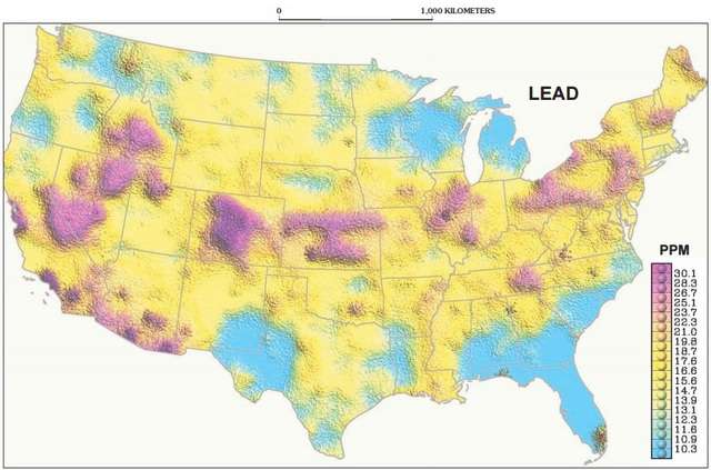 Geochemical Landscapes of the Conterminous United States - New Map Presentations for 22 Elements By N. Gustavsson, B. Bølviken, D.B. Smith, and R.C. Severson (U.S. Geological Survey Professional Paper 1648) (USGS, November 2001 - PDF) Geochemical Landscapes of the Conterminous United States - New Map Presentations for 22 Elements By N. Gustavsson, B. Bølviken, D.B. Smith, and R.C. Severson (U.S. Geological Survey Professional Paper 1648) (USGS, November 2001 - PDF)If you want a little scare about the potential, read the section titled "Drainage_tunnels" in that link cited above. "Collapses within the tunnel that began in 1995 partially blocked flow, and have created a large reservoir of an estimated one billion gallons (3.8 million cubic meters) of water within the tunnel behind the collapse. In February 2008, concerns became public that if the collapse dam should suddenly fail, as has happened in other mine drainage tunnels in Colorado (such as the Yak tunnel and the Argo Tunnel), a large slug of contaminated water would suddenly flow out of the tunnel, overwhelm the treatment facilities, and flow into the Arkansas River." |
|
|
|
Post by High Sierra Fan on Aug 12, 2015 11:47:53 GMT -8
|
|
Deleted
Deleted Member
Posts: 0
|
Post by Deleted on Aug 13, 2015 17:17:10 GMT -8
. . . here's another drainage with a similar hue Looks more like carrot juice than orange juice. Heck I've seen sites where the color would be something approaching beet red with dense enough sediment. |
|
 Image Credit / Coolkat


