Post by GaliWalker on Sept 28, 2015 8:07:15 GMT -8
Sep 27, 2015: Dolly Sods (central)
When a weather forecast calls for a 50% chance of rain, take it to mean 100%. That's what I faced for my entire hike in West Virginia's Dolly Sods area; wall to wall precipitation and suffocating mist for nearly 10hrs of hiking.
The final week of September kicks off my search for fall foliage and psychedelic colors. Near the start of the season I prefer to roam the higher elevations, where fall begins earlier. The first victim to suffer my company this year was West Virginia's Dolly Sods area, a perennial favorite at any time of the year. I selected a somewhat weird route in the central part of the area, which featured a good mix of vistas and waterworks but quite a bit of backtracking:
- Wildlife Trail to Rohrbaugh Plains Trail, hang a left and head about a half mile to the No Name Vista.
- Retrace my steps on the Rohrbaugh Plains Trail and continue past the Wildlife Trail intersection. Take the Fisher Springs Run Trail down to Red Creek.
- Climb up along Red Creek Trail to the Rocky Point Trail intersection but keep going along the Red Creek Trail to the Forks.
- Retrace my steps on the Red Creek Trail but take the Rocky Point Trail, which I ignored earlier, to wrap around Lion's Head. Climb up to Lion's Head.
- Retrace my steps along the Rocky Point Trail to the Red Creek Trail. Head back down to Red Creek and then back up to the car using the same trails I'd used on the approach.
I left Pittsburgh at 3:15am. As I reached the Dolly Sods plateau a little before 7:00am the mist had become thick enough that visibility was down to 20-30 yards. A gentle but persistent rain and cool temperatures greeted me as I reluctantly left the cozy confines of the car. Conditions were still a bit dim and there wasn't much to see, other than the inside of a cloud, so I mostly kept my head down as I headed down the Wildlife Trail.
The thick mist was still embracing me as I took the Rohrbaugh Plains Trail towards the No Name Vista. As expected, the No Name Vista was also the No View Vista.
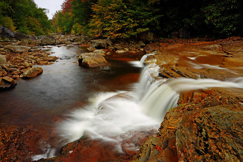
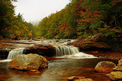
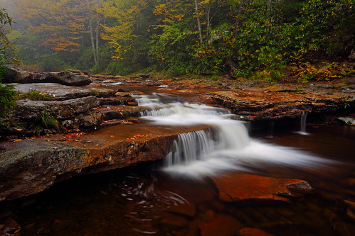
Ok, so no view, but my next objective – Red Creek Falls – should have perfect lighting. I kept this happy thought in my head as I retraced my steps on the Rohrbaugh Plains Trail and then dropped down to Red Creek via the Fisher Springs Run Trail. Red Creek Falls wasn't its usual booming self, but it did have enough water to keep me entertained for nearly an hour.
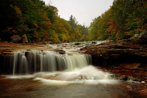
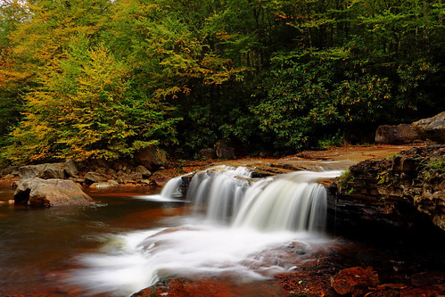
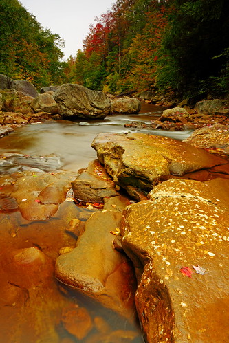
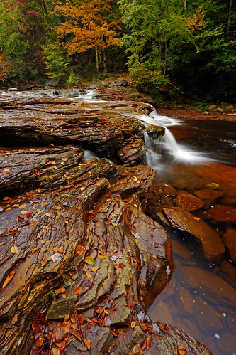
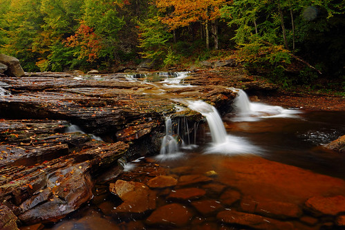
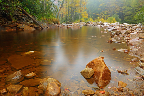
I crossed Red Creek and then took the Red Creek Trail up to its intersection with the Rocky Point Trail. Since the mist just above me was as thick as ever, I decided to head towards the Forks first and then tackle Lion's Head later. I continued on the Red Creek Trail to one of the most scenic spots in the central Dolly Sods, the Forks. Here, the Left Fork of Red Creek and Red Creek came together in a complex of cascading waterfalls and limpid pools. Once again, the misty conditions were in my favor, providing a lovely atmosphere to the surroundings.
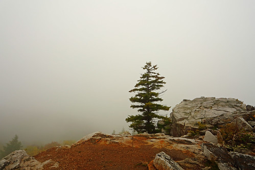
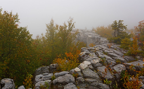
After the photographic high at the Forks, I steeled myself for the impending low at Lion's Head. I returned along the Red Creek Trail to the Rocky Point Trail in short order. Unfortunately, the next 1.5mi along the Rocky Point Trail were awful - walking on pointy rocks is never fun, but when they are wet and slimy from a steady dose of precipitation it's even worse. Myriad routes, of various stages of difficulty, allow access to Lion's Head. This particular time, I found yet another new approach. Clambering up the wet boulders in the suddenly much heavier rain wasn't quite as bad as the Rocky Point Trail, but it was close. Lion's Head was a windswept expanse, in which the rain was flying sideways. I hurriedly snapped a single photo and got out of the open. Oh yeah, no views.
The way back was in much the same conditions as I'd faced on the way in. I didn't bother taking the camera out anymore.
Hiking/photography stats: 14.1mi, 2300ft gain, 9hr 20min
When a weather forecast calls for a 50% chance of rain, take it to mean 100%. That's what I faced for my entire hike in West Virginia's Dolly Sods area; wall to wall precipitation and suffocating mist for nearly 10hrs of hiking.
The final week of September kicks off my search for fall foliage and psychedelic colors. Near the start of the season I prefer to roam the higher elevations, where fall begins earlier. The first victim to suffer my company this year was West Virginia's Dolly Sods area, a perennial favorite at any time of the year. I selected a somewhat weird route in the central part of the area, which featured a good mix of vistas and waterworks but quite a bit of backtracking:
- Wildlife Trail to Rohrbaugh Plains Trail, hang a left and head about a half mile to the No Name Vista.
- Retrace my steps on the Rohrbaugh Plains Trail and continue past the Wildlife Trail intersection. Take the Fisher Springs Run Trail down to Red Creek.
- Climb up along Red Creek Trail to the Rocky Point Trail intersection but keep going along the Red Creek Trail to the Forks.
- Retrace my steps on the Red Creek Trail but take the Rocky Point Trail, which I ignored earlier, to wrap around Lion's Head. Climb up to Lion's Head.
- Retrace my steps along the Rocky Point Trail to the Red Creek Trail. Head back down to Red Creek and then back up to the car using the same trails I'd used on the approach.
I left Pittsburgh at 3:15am. As I reached the Dolly Sods plateau a little before 7:00am the mist had become thick enough that visibility was down to 20-30 yards. A gentle but persistent rain and cool temperatures greeted me as I reluctantly left the cozy confines of the car. Conditions were still a bit dim and there wasn't much to see, other than the inside of a cloud, so I mostly kept my head down as I headed down the Wildlife Trail.
The thick mist was still embracing me as I took the Rohrbaugh Plains Trail towards the No Name Vista. As expected, the No Name Vista was also the No View Vista.
Ok, so no view, but my next objective – Red Creek Falls – should have perfect lighting. I kept this happy thought in my head as I retraced my steps on the Rohrbaugh Plains Trail and then dropped down to Red Creek via the Fisher Springs Run Trail. Red Creek Falls wasn't its usual booming self, but it did have enough water to keep me entertained for nearly an hour.
I crossed Red Creek and then took the Red Creek Trail up to its intersection with the Rocky Point Trail. Since the mist just above me was as thick as ever, I decided to head towards the Forks first and then tackle Lion's Head later. I continued on the Red Creek Trail to one of the most scenic spots in the central Dolly Sods, the Forks. Here, the Left Fork of Red Creek and Red Creek came together in a complex of cascading waterfalls and limpid pools. Once again, the misty conditions were in my favor, providing a lovely atmosphere to the surroundings.
After the photographic high at the Forks, I steeled myself for the impending low at Lion's Head. I returned along the Red Creek Trail to the Rocky Point Trail in short order. Unfortunately, the next 1.5mi along the Rocky Point Trail were awful - walking on pointy rocks is never fun, but when they are wet and slimy from a steady dose of precipitation it's even worse. Myriad routes, of various stages of difficulty, allow access to Lion's Head. This particular time, I found yet another new approach. Clambering up the wet boulders in the suddenly much heavier rain wasn't quite as bad as the Rocky Point Trail, but it was close. Lion's Head was a windswept expanse, in which the rain was flying sideways. I hurriedly snapped a single photo and got out of the open. Oh yeah, no views.
The way back was in much the same conditions as I'd faced on the way in. I didn't bother taking the camera out anymore.
Hiking/photography stats: 14.1mi, 2300ft gain, 9hr 20min