|
|
Post by oc6088 on Oct 5, 2017 14:59:46 GMT -8
I am looking to backpack the Adirondack area and do an appx 50 miles loop or through hike/section. I am a moderate hiker. I can handle some peaks. (More peaks, better views)
I like the look of the Cranberry Lake 50 loop, but I have never been backpacking to that area.
I would like to go to the Adirondack area because my sister in law lives out there (Malone area) and she always says it's "beautiful" and I should come out and backpack the area. However she is not a backpacker.
Does anyone have any suggestions for an apprx 50 mile backpack trip? I really like having an area that has set "primitive campsites." I hike alone and the campsites seem to give me a level of comfort. (Not sure why) it doesn't have to be a loop, I am sure she will drop me off at one end.
Sometimes there is information overload on the internet. If someone would give me their thoughts/ideas and point me in the right direction, I would appreciate it. Thanks in advance!
|
|
|
|
Post by jmitch on Oct 5, 2017 16:49:27 GMT -8
CL50 is great, but has few views and spends little time along its namesake lake. Lots of ponds, wetlands. Trail can be very wet and even crosses the tops of beaver dams. High Falls is beautiful and don't miss the view from Cat Mtn. For more views check out Pharaoh Lake Wilderness or Lake George wild forest, but they are on the eastern side of the Adks.
|
|
walkswithblackflies
Trail Wise!
Resident terrorist-supporting eco-freak bootlicker
Posts: 6,952 
|
Post by walkswithblackflies on Oct 6, 2017 5:11:22 GMT -8
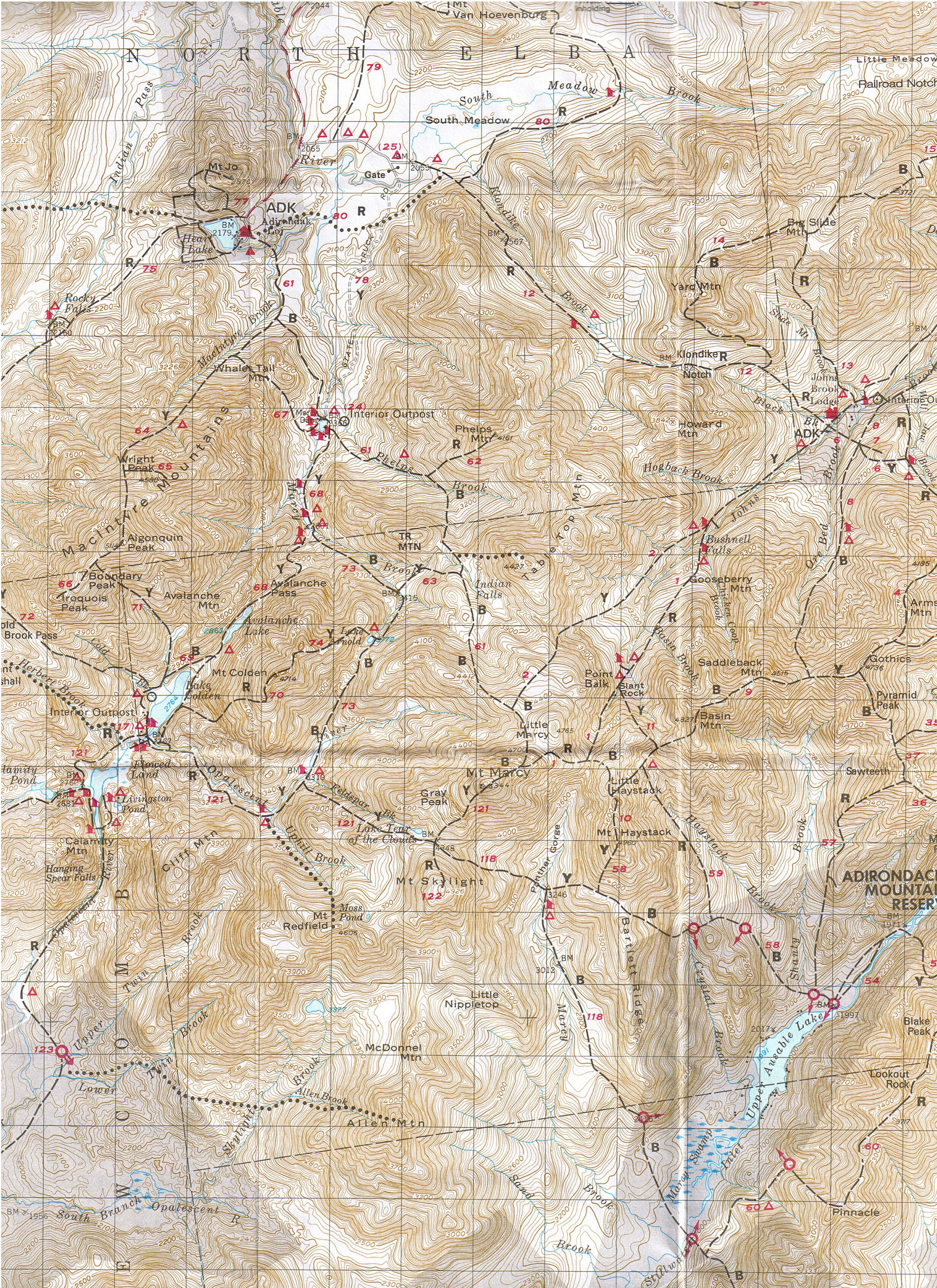
When are you going? Here's a bang-for-your-buck itinerary. You'll need a map to follow along. There are several opportunities to peakbag along the way. Feel free to post here or PM me with any questions. Start at Heart Lake / High Peaks Information Center / Adirondak Loj - Indian Pass - Henderson Lake - Upper Works - Flowed Lands - Lake Colden - Up the Opalescent River to Uphill/Feldspar lean-tos - Four Corners (Marcy/Skylight col). Here you have 2 choices: 1) Stay high on the Upper Great Range (maybe add Skylight first) - Marcy - Haystack - Basin - Saddleback - Gothics - Pyramid (best view in the High Peaks) - Lower Ausable Lake - Side trip to Fish Hawk Cliffs / Indian Head - Ausable Club / St Huberts 2) Drop down to Upper Ausable Lake. Again 2 choices: A) Up Sawteeth to Pyramid (best view in the High Peaks) - Lower Ausable Lake - Side trip to Fish Hawk Cliffs / Indian Head - Ausable Club / St Huberts; or B) Up Pinnacle Ridge to Blake - Colvin - Indian Head - Fish Hawk Cliffs - Ausable Club / St Huberts Side trip: Drive up Whiteface with your sister. |
|
|
|
Post by oc6088 on Oct 6, 2017 6:47:55 GMT -8
Thanks for the suggestions. I am pretty flexible when I can go. I am thinking next spring? Before the bugs?
These suggestions make it much easier. The CL50 sounds pretty familiar with another trail I did. I thought it would be a nice shore line hike or on peaks and there was no access to the lake and it was just muddy. I was pretty disappointed.
I will continue my research.
|
|
|
|
Post by oc6088 on Oct 6, 2017 7:02:50 GMT -8
Start at Heart Lake / High Peaks Information Center / Adirondak Loj - Indian Pass - Henderson Lake - Upper Works - Flowed Lands - Lake Colden - Up the Opalescent River to Uphill/Opalescent lean-tos - Four Corners (Marcy/Skylight col). Here you have 2 choices: Any idea where I can find a map? What organization/park would this be under? I'm having a hard time finding info. Thanks. |
|
walkswithblackflies
Trail Wise!
Resident terrorist-supporting eco-freak bootlicker
Posts: 6,952
|
Post by walkswithblackflies on Oct 6, 2017 7:30:55 GMT -8
|
|
walkswithblackflies
Trail Wise!
Resident terrorist-supporting eco-freak bootlicker
Posts: 6,952
|
Post by walkswithblackflies on Oct 6, 2017 8:00:30 GMT -8
|
|
|
|
Post by oc6088 on Oct 6, 2017 8:16:03 GMT -8
wow. Thank you so much. You went above and beyond for me  Are those maps above the ones from adirondacks trail map link? (The first link) It looks like a great map. Just want to make sure I buy the best one. |
|
walkswithblackflies
Trail Wise!
Resident terrorist-supporting eco-freak bootlicker
Posts: 6,952
|
Post by walkswithblackflies on Oct 6, 2017 10:30:12 GMT -8
|
|
walkswithblackflies
Trail Wise!
Resident terrorist-supporting eco-freak bootlicker
Posts: 6,952
|
Post by walkswithblackflies on Oct 6, 2017 10:35:53 GMT -8
I am pretty flexible when I can go. I am thinking next spring? Before the bugs? Spring can be muddy, muddy, muddy. Or icy. Or snowy. And most likely all three at the same time. Blackfly season is typically around Memorial Day to 4th of July. Skeeters and deerflies last until early September. If you're flexible, September/October is ideal. Peak leaves are typically in early October. Winter is beautiful if you're so inclined. |
|
 Image Credit / Coolkat