

High Falls and Seneca Creek Falls (West Virginia, 4/15/'17)
Apr 16, 2017 7:25:13 GMT -8
Coolkat likes this
Post by GaliWalker on Apr 16, 2017 7:25:13 GMT -8
Two waterfall hikes in West Virginia (April/15/2017)
High Falls of the Cheat River, Seneca Creek Falls
With spring in full swing in the lowlands, yesterday I decided to check out the higher country of West Virginia on two back-to-back waterfall hikes. This was a reprise of a trip I'd made two years ago, selected so that I wouldn't have to do a lot of research!
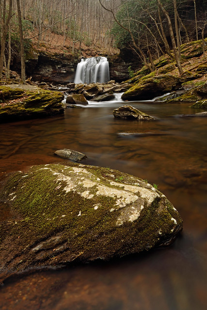
High Falls of the Cheat River, West Virginia
I left Pittsburgh in the wee morning hours (2:40am to be precise), timing my arrival at the trailhead for the High Falls Trail for 6:00am (45min before sunrise). It was probably just bright enough to see by the naked eye, but I decided to use my headlamp for the first 15min due to the relative unfamiliarity of the trail. By the time I switched it off, I was walking through an intriguing stand of hawthorn trees near a meadow. I find hawthorns interesting because of their huge vestigial spikes (aka thorns), developed for now extinct mega-fauna.

After the meadow a steady climb took me up to the ridge crest of Shavers Mountain, after which I dropped down into the valley of the Shavers Fork of the Cheat River. A final 0.5mi walk along a set of railway tracks took me to the High Falls of the Cheat River, 1.7hrs after starting.

My timing was good: I was able to spend 2hrs there before direct sunlight began to play on the waterfall, making photography untenable.


Cheat River
The way back was also interesting, because the brighter conditions had the display of wildflowers popping.


Piper's anemone

Trout lily
Hiking/photography stats: 7.2mi, 1430ft elevation gain, 5hrs
Seneca Creek Falls, West Virginia
After my High Falls hike a short 40min drive deposited me at the trailhead for the Horton Trail. This is probably the quickest way to access Seneca Creek Falls, although one has to climb up and over Allegheny Mountain to do so; pretty similar to what I'd already done on my first hike.
The walk up to the ridge crest of Allegheny Mountain was beside pretty Two Springs Run. The grade was gentle, except near the very top. The wildflower show here was a little better than on my previous hike, which was just the tonic I needed, since I was somewhat dragging by this point.


The drop into the Seneca Creek valley was steeper but the trail surface was less rocky. The Seneca Creek Falls glen was just as special as always.


Hiking/photography stats: 7mi, 1950ft elevation gain, 5hrs
Total trip time: 18hrs
High Falls of the Cheat River, Seneca Creek Falls
With spring in full swing in the lowlands, yesterday I decided to check out the higher country of West Virginia on two back-to-back waterfall hikes. This was a reprise of a trip I'd made two years ago, selected so that I wouldn't have to do a lot of research!
High Falls of the Cheat River, West Virginia
I left Pittsburgh in the wee morning hours (2:40am to be precise), timing my arrival at the trailhead for the High Falls Trail for 6:00am (45min before sunrise). It was probably just bright enough to see by the naked eye, but I decided to use my headlamp for the first 15min due to the relative unfamiliarity of the trail. By the time I switched it off, I was walking through an intriguing stand of hawthorn trees near a meadow. I find hawthorns interesting because of their huge vestigial spikes (aka thorns), developed for now extinct mega-fauna.
After the meadow a steady climb took me up to the ridge crest of Shavers Mountain, after which I dropped down into the valley of the Shavers Fork of the Cheat River. A final 0.5mi walk along a set of railway tracks took me to the High Falls of the Cheat River, 1.7hrs after starting.
My timing was good: I was able to spend 2hrs there before direct sunlight began to play on the waterfall, making photography untenable.
Cheat River
The way back was also interesting, because the brighter conditions had the display of wildflowers popping.
Piper's anemone
Trout lily
Hiking/photography stats: 7.2mi, 1430ft elevation gain, 5hrs
Seneca Creek Falls, West Virginia
After my High Falls hike a short 40min drive deposited me at the trailhead for the Horton Trail. This is probably the quickest way to access Seneca Creek Falls, although one has to climb up and over Allegheny Mountain to do so; pretty similar to what I'd already done on my first hike.
The walk up to the ridge crest of Allegheny Mountain was beside pretty Two Springs Run. The grade was gentle, except near the very top. The wildflower show here was a little better than on my previous hike, which was just the tonic I needed, since I was somewhat dragging by this point.
The drop into the Seneca Creek valley was steeper but the trail surface was less rocky. The Seneca Creek Falls glen was just as special as always.
Hiking/photography stats: 7mi, 1950ft elevation gain, 5hrs
Total trip time: 18hrs