|
|
Post by Jeren Hakkari on Feb 24, 2017 21:37:19 GMT -8
Hi guys!
I'm planning an 18-day backpacking trip to Yosemite, in early April. The basic idea is to hike from the Visitor's Center to Yosemite Valley, then start off on a 5 day hike to Sequoia National Forest. Noodle around there for about 4 days, than hoof it back to Yosemite, preferably along a different route than I came down on. Maybe to Tuolumne Meadows? No possibility of driving; I'm taking Amtrak.
So the basic questions are thus:
1. Is this even possible? Like, would snow trap me in some manner of icy tomb? I'm a Texas hotlander, so I'm not too clear about this whole "snow" thing.
2. Are there any trails I can take from Yosemite to Sequoia?
3. Any ideas on how to pack 18 days' worth of food with me?
Also, I'm not sure what the rules are about a trip like this. Do I give the park rangers an itinerary or something?
Any help would be appreciated!
|
|
zeke
Trail Wise!
Peekaboo slot 2023
Posts: 9,886 
|
Post by zeke on Feb 25, 2017 3:20:09 GMT -8
Hip deep snow. 3 bear canisters to hold your food. 100L pack to hold all of your gear. Probably 100 lbs, since you are a noob and not UL. (Best meal planners still carry 1.5-2 pounds of food per day. Canisters hold about 7 days worth of food, and you will need room for all things that have a smell to them. Canisters weigh about 2 lbs each. Thats 42 lbs just for food)
Try something less arduous for your first trip.
|
|
markskor
Trail Wise!
Mammoth Lakes & Tuolumne Meadows...living the dream
Posts: 651
|
Post by markskor on Feb 25, 2017 6:50:00 GMT -8
Let me get this right...you plan on doing this 500 miles in April you say? a quick 5-day hike from Yosemite Valley to Sequoia carrying all food? and not too clear about this whole "snow" thing?
Probably not happening.
Agree with zeke, try something possible instead. Right now the Sierra holds a good 20+' of the white stuff...Mammoth Lakes (here at 8,000 feet elev) has passed 500" of seasonal snow...and your trail will have to cross multiple 10,000 foot passes...add in not having the correct snow gear and never having walked miles over snow?
Have you even looked closely at a map of the Sierra? It is not 5 days from Yosemite's Valley Visitor Center to SEKI? Even if it were later in the season and if there were no snow...it is still not a 5-day route...try 2 weeks instead just for this segment...if dry?
All Tuolumne facilities (roads, campground, and store) will be closed until late June...
Perhaps consider a slightly less ambitious itinerary...we can help you pare this down some... to something do-able...whatever. Can you postpone this 2 - 3 months?
Good luck. Let us know how it goes, after.
|
|
zeke
Trail Wise!
Peekaboo slot 2023
Posts: 9,886
|
Post by zeke on Feb 25, 2017 6:58:50 GMT -8
Maybe this guy is hitch-hiking from Yosemite to Sequoia, but it would still be an ambitious trip for someone new to traveling on foot.
|
|
|
|
Post by Jeren Hakkari on Feb 25, 2017 7:06:54 GMT -8
This is why I needed some experienced advice. I figured I was overreaching, though I didn't find any info online about there being THAT much snow; would you be able to share your weather source? The thought was that it was better to overreach than underachieve.
Anyway, would anyone have suggestions about alternative trips, reachable by train? I believe I can get to Grand Teton, Yellowstone (though that is doubtless buried under powder as well), Rocky Mountain and Crater Lake, at least according to the Amtrak website. The window for the trip sadly cannot be changed, as April is the only month where I have no job or lease and am not yet in college. Thanks for the quick replies, and I definitely appreciate the detailed requirements for such a journey, zeke!
|
|
markskor
Trail Wise!
Mammoth Lakes & Tuolumne Meadows...living the dream
Posts: 651
|
Post by markskor on Feb 25, 2017 7:13:21 GMT -8
|
|
davesenesac
Trail Wise!
Our precious life is short within eternity, don't waste it!
Posts: 1,710
|
Post by davesenesac on Feb 25, 2017 10:54:53 GMT -8
|
|
zeke
Trail Wise!
Peekaboo slot 2023
Posts: 9,886
|
Post by zeke on Feb 25, 2017 12:45:01 GMT -8
I believe I can get to Grand Teton, Yellowstone (though that is doubtless buried under powder as well), Rocky Mountain and Crater Lake, at least according to the Amtrak website.
I know a train or bus runs to Grand Canyon, but not sure where connections are made. Try Flagstaff. |
|
|
|
Post by Jeren Hakkari on Feb 25, 2017 16:12:53 GMT -8
Okay, so Grand Canyon it is. Was wanting forests, but I guess I can deal with visiting one of the most amazingly stunning and beautiful places in the world.
At the moment, I have a rain tarp for shelter, rather than a standalone tent. Is the entire canyon floor solid rock, or are there a decent number of locations where it's feasible to drive in tent stakes? Or is camping only available in designated campgrounds?
|
|
zeke
Trail Wise!
Peekaboo slot 2023
Posts: 9,886
|
Post by zeke on Feb 25, 2017 16:30:59 GMT -8
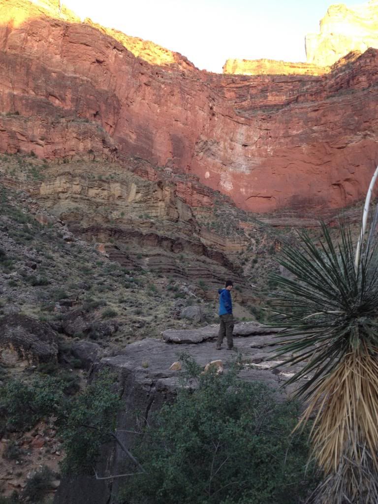
Plenty of locations where stakes will drive easily. Most of the time, I sleep out under the stars there. In some areas, designated sites are the only choice. In others, disbursed camping is allowed. Go prepared to sleep in Mather a couple of nights, until a walk up permit becomes available for a route within your abilities. Think Corridor trails. Ask at the BC office. You might be surprised by the trees, cacti, and critters. A pic of one of my bp'ing buddies from a 2013 trip we did together.
|
|
|
|
Post by Jeren Hakkari on Feb 25, 2017 18:21:11 GMT -8
That is one heck of a photo. Which trail was it taken on?
From the research I've done so far, I'm not sure I'd be able to get the Backcountry Permit Request that I'd need to actually spend the night out of a campground - they are normally filed 4 months in advance, and fill up quite quickly - and both Bright Angel and Indian Garden campgrounds are completely booked in April. Wish I'd thought of taking a sabbatical sooner.
|
|
zeke
Trail Wise!
Peekaboo slot 2023
Posts: 9,886
|
Post by zeke on Feb 26, 2017 4:10:37 GMT -8
That photo was taken at Salt Creek, a camp spot along the Tonto between Indian Gardens and Hermit Creek. Yes, Indian Gardens and bright Angel campgrounds will be full, but there will be walk up permits available for other places with water. I am assuming it will just be you, not a group of friends. Be honest with the Ranger at the permit station about your experience, and be flexible about your days. If you don't get a permit immediately, there are several good day hikes available from the shuttle bus. Doing one or 2 of those while waiting on the permit could acclimate you to hiking down, then up, the Canyon walls. Do some reading on the GRCA.gov site. Camping at the top, in Mather, would be the least appealing option, but still a good one. Call the BC office and get a better feel for the walk up procedure. 928.638.2125 Also, read the Trip Planner
|
|
davesenesac
Trail Wise!
Our precious life is short within eternity, don't waste it!
Posts: 1,710
|
Post by davesenesac on Feb 26, 2017 7:39:53 GMT -8
Train??? Well Zeke gave you one of the only parks connected by trains. Anyone visiting parks in The West without a car, especially for extended periods is asking to be extremely limited. Consider that almost all Europeans that fly in rent at airports. Public bus transportation tends to be very limited outside urban areas.
|
|
|
|
Post by High Sierra Fan on Feb 28, 2017 22:59:18 GMT -8
Bad year to give up snowshoeing.  cdec.water.ca.gov/cdecapp/snowapp/sweq.action cdec.water.ca.gov/cdecapp/snowapp/sweq.actionThe Tuolumne rangers are reporting ten feet on the ground. Up near Tahoe the snowfall is already over fifty feet and the season usually goes until April 1... Mammoth south of Yosemite has announced Fourth of July skiing. www.nps.gov/yose/blogs/tmconditions.htmI'd think the Appalachian Trail starting in Georgia might better fit that time frame and you'd have that length and more ahead. Plus lot's of planning resources. www.appalachiantrail.orgWhat's accessble via public transportation thst far south I couldn't say. Odds are it's listed somewhere. Hmmm so it looks like if you started at Harpers Ferry and headed south (? given the season it might be less "winter" that direction, but I don't know) a train would get you right to the trailhead. Bonus: on the AT resupply access is never 18 days apart. www.appalachiantrail.org/home/explore-the-trail/transportation-options |
|
 Image Credit / Coolkat


