

Damp day in Otter Creek Wilderness (West Virginia, 4/23/16)
Apr 24, 2016 10:26:27 GMT -8
rwtb123 and melsdad like this
Post by GaliWalker on Apr 24, 2016 10:26:27 GMT -8
A damp day in the Otter Creek Wilderness (April 23, 2016)
This Saturday, I spent an extremely wet day sampling the loveliness of West Virginia's Otter Creek Wilderness. Rain and misty conditions had this rhododendron classic at its vibrant best. Yeah, I got wet, even to the point of misery at times, but as they say, you can't make an omelet without breaking some eggs.
Route: Mylius Trail - Shavers Mountain Trail - Green Mountain Trail - Possession Camp Trail - Moore Run Trail - McGowan Mountain road - Yellow Creek Trail - Otter Creek Trail - Mylius Trail
Hiking/photography stats: 22.7mi, 3750ftelevation gain, 11hrs
I began my hike from the Mylius Trailhead at first light (6:00am). It had rained heavily on my long 3.5hr drive from Pittsburgh. Thankfully, my walk started in the gentle variety. This early in the morning, the light was relatively dull and I kept the camera in its case.
The Mylius Trail took me to a notch on Shavers Mountain's ridge. Here, I turned right to continue climbing up along the ridge, now on the Shavers Mountain Trail. A few steps along this trail and the heavens opened up. Heavy rain began to pelt me and the rhododendron bushes that covered the ridge. These, already wet from rain over the past night, now just stood at the ready to shed water at the merest brush. And brush them I did, since the trail had plenty of spots where there was no clear passage. The next 4mi of hiking was some of the wettest stretches I've had to endure. While I remained dry from the waist up, my pants were soaked through (I should have put on my rain pants, but alas these lay in my car). My gaiters and boots kept my feet dry for a while, until the water that had soaked though my pants - my gaiters were strapped on outside the pant legs - began to use my socks as a conduit.
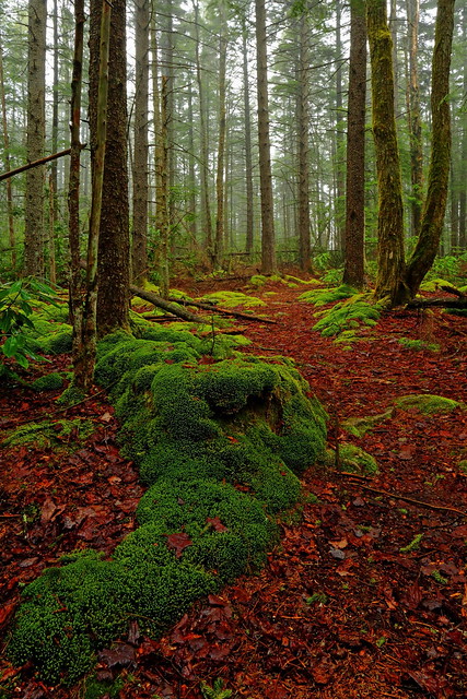
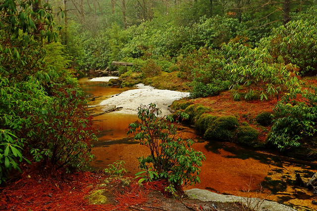
The Shavers Mountain Trail gave way to the Green Mountain Trail and even denser rhododendron thickets. An assortment of mud holes decided to muscle their way into the action, but that was just overkill; I was beyond caring. Finally, I took a left on the Possession Camp Trail, and the rhododendron thickets began to thin out. The Possession Creek Trail led me gently down to scenic Otter Creek. Since I was in a lull in the attack from the elements, I was able to fully enjoy the lush greens that looked so vibrant in the misty conditions, and regain my balance.


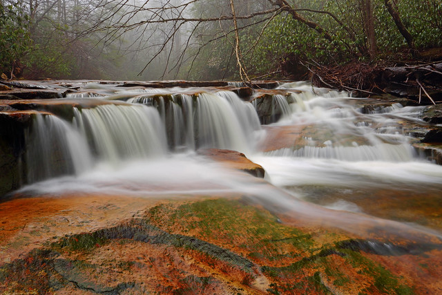
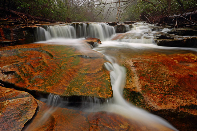
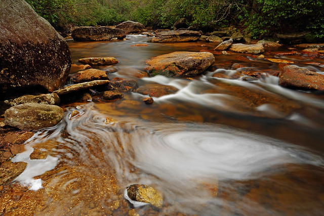
The Possession Camp Trail ended at a gorgeous set of cascades on Otter Creek. The rain had stopped, although mist still blanketed the surroundings. I spent about 30min there taking pictures before resuming my hike.
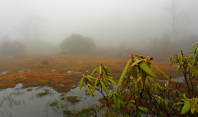
Otter Creek is hemmed in by Shavers Mountain on one side and McGowan Mountain on the other. I had already rolled over Shavers Mountain. It was now time to do the same on McGowan Mountain. After crossing Otter Creek via a rock hop, I began to climb up gently along the Moore Run Trail. The initial travel was through open woods, which allowed me to dry out. Unfortunately, the upper reaches abounded with rhododendron tunnels that encroached liberally onto the trail. And it got worse: around 3mi along the Moore Run Trail I run into a boggy section, maybe 100yds across. The trail disappeared at its edge, and with visibility at 20yds due to the mist there was no indication of where the far end was. I took my first step into the bog and sank ankle deep into squishy terrain. 20yds further near a copse of trees, each ginger step continuing to sink ankle deep into the muck, I cast off a few dozen yards to my left hoping to pick up the trail. I was successful when I came upon a line of submerged logs that wasn't visible until you stood right atop them. I was able to stick to this faint trail for the remaining boggy section.

Drat, where's the end of the trail?
By now my nerves were frazzled and I needed a mental break. So, instead of taking the McGowan Mountain Trail, I continued for a further 0.1mi along Moore Run Trail until I hit the McGowan Mountain Road. This gravel road paralleled the namesake trail for a bit before diverging somewhat. Approximately 4mi of fast road walking got me to the start of the Yellow Creek Trail, which would take me back down into the Otter Creek valley. 0.6mi of beautiful , non-stressful forest hiking, alongside Yellow Creek, ensued which got me to the junction with the McGowan Mountain Trail. I was back on track. Yes, I'd added an additional 1.2mi to my intended hike but had got the mental break I craved.


Yellow Creek
A fast descent via the remaining portion of the Yellow Creek Trail - not as nice as the extra part I'd added - deposited me back beside Otter Creek. I took a left onto the Otter Creek Trail and hiked beside the creek for the next 1.8mi. This got me to the junction with the Mylius Trail, a straight shot back to the car. One final rock-hopped crossing of Otter Creek, a short climb up the flank of Shavers Mountain, and then a quick descent had me at my car, almost 11hrs after starting.

This Saturday, I spent an extremely wet day sampling the loveliness of West Virginia's Otter Creek Wilderness. Rain and misty conditions had this rhododendron classic at its vibrant best. Yeah, I got wet, even to the point of misery at times, but as they say, you can't make an omelet without breaking some eggs.
Route: Mylius Trail - Shavers Mountain Trail - Green Mountain Trail - Possession Camp Trail - Moore Run Trail - McGowan Mountain road - Yellow Creek Trail - Otter Creek Trail - Mylius Trail
Hiking/photography stats: 22.7mi, 3750ftelevation gain, 11hrs
I began my hike from the Mylius Trailhead at first light (6:00am). It had rained heavily on my long 3.5hr drive from Pittsburgh. Thankfully, my walk started in the gentle variety. This early in the morning, the light was relatively dull and I kept the camera in its case.
The Mylius Trail took me to a notch on Shavers Mountain's ridge. Here, I turned right to continue climbing up along the ridge, now on the Shavers Mountain Trail. A few steps along this trail and the heavens opened up. Heavy rain began to pelt me and the rhododendron bushes that covered the ridge. These, already wet from rain over the past night, now just stood at the ready to shed water at the merest brush. And brush them I did, since the trail had plenty of spots where there was no clear passage. The next 4mi of hiking was some of the wettest stretches I've had to endure. While I remained dry from the waist up, my pants were soaked through (I should have put on my rain pants, but alas these lay in my car). My gaiters and boots kept my feet dry for a while, until the water that had soaked though my pants - my gaiters were strapped on outside the pant legs - began to use my socks as a conduit.
The Shavers Mountain Trail gave way to the Green Mountain Trail and even denser rhododendron thickets. An assortment of mud holes decided to muscle their way into the action, but that was just overkill; I was beyond caring. Finally, I took a left on the Possession Camp Trail, and the rhododendron thickets began to thin out. The Possession Creek Trail led me gently down to scenic Otter Creek. Since I was in a lull in the attack from the elements, I was able to fully enjoy the lush greens that looked so vibrant in the misty conditions, and regain my balance.
The Possession Camp Trail ended at a gorgeous set of cascades on Otter Creek. The rain had stopped, although mist still blanketed the surroundings. I spent about 30min there taking pictures before resuming my hike.
Otter Creek is hemmed in by Shavers Mountain on one side and McGowan Mountain on the other. I had already rolled over Shavers Mountain. It was now time to do the same on McGowan Mountain. After crossing Otter Creek via a rock hop, I began to climb up gently along the Moore Run Trail. The initial travel was through open woods, which allowed me to dry out. Unfortunately, the upper reaches abounded with rhododendron tunnels that encroached liberally onto the trail. And it got worse: around 3mi along the Moore Run Trail I run into a boggy section, maybe 100yds across. The trail disappeared at its edge, and with visibility at 20yds due to the mist there was no indication of where the far end was. I took my first step into the bog and sank ankle deep into squishy terrain. 20yds further near a copse of trees, each ginger step continuing to sink ankle deep into the muck, I cast off a few dozen yards to my left hoping to pick up the trail. I was successful when I came upon a line of submerged logs that wasn't visible until you stood right atop them. I was able to stick to this faint trail for the remaining boggy section.
Drat, where's the end of the trail?
By now my nerves were frazzled and I needed a mental break. So, instead of taking the McGowan Mountain Trail, I continued for a further 0.1mi along Moore Run Trail until I hit the McGowan Mountain Road. This gravel road paralleled the namesake trail for a bit before diverging somewhat. Approximately 4mi of fast road walking got me to the start of the Yellow Creek Trail, which would take me back down into the Otter Creek valley. 0.6mi of beautiful , non-stressful forest hiking, alongside Yellow Creek, ensued which got me to the junction with the McGowan Mountain Trail. I was back on track. Yes, I'd added an additional 1.2mi to my intended hike but had got the mental break I craved.
Yellow Creek
A fast descent via the remaining portion of the Yellow Creek Trail - not as nice as the extra part I'd added - deposited me back beside Otter Creek. I took a left onto the Otter Creek Trail and hiked beside the creek for the next 1.8mi. This got me to the junction with the Mylius Trail, a straight shot back to the car. One final rock-hopped crossing of Otter Creek, a short climb up the flank of Shavers Mountain, and then a quick descent had me at my car, almost 11hrs after starting.
