

Post by GaliWalker on Oct 9, 2023 5:25:05 GMT -8
Three Ridges (Virginia, Oct/8/2023)
The Three Ridges circuit, or rather a 'lollipop' loop, is a popular hike in Virginia's George Washington National Forest. One heads southbound on the Appalachian Trail, and then transitions to the Mau-Har Trail to return back to Appalachian Trail to close the loop, and then retraces their steps back to the car. It's a somewhat rugged hike due to the rocky nature of the trails, but all climbs bar one are moderate. I was hoping to catch some nice fall colors, but central Virginia was still mostly in late summer mode, with only the barest hint of changing colors.
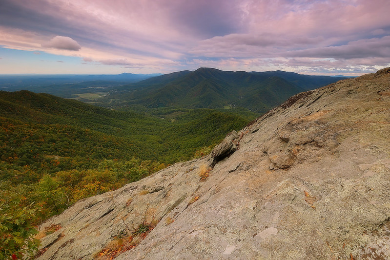
I began my hike at 7:10am from Reed Gap, on the Blue Ridge Parkway, just a dozen or so miles south of Shenandoah National Park. The temperature was in the low 40s, which felt much cooler due to the windy conditions. The latter would stick around for the entire day. The Appalachian Trail started off by climbing over a hill before dropping down to the intersection with the northern end of the Mau-Har Trail, up which I would be returning. I continued on the Appalachian trail, which made a gentle climb over the forested Bee Mountain and up to a northern knob of Three Ridges, 3.6mi in and 0.8mi shy of the summit. A large rocky vista provided an expansive view towards the south, where The Priest took center stage. It had been a pretty uneventful woods hike up to this point, so I was glad for the great views.
Although the hike descriptions I'd read mentioned additional views, I saw nothing worth taking the camera out for. Even the summit was a forested no-show, as far as vistas go. Chimney Rock was so inconspicuous that I actually went a few hundred yards past it, before heading back to it and hunting around until I was finally rewarded with a window looking out towards the east. (On further reflection, I think I may have missed the actual Chimney Rock vista.) Finally, about 0.7mi past Chimney Rock, the trail passed over a rocky bench which featured a nice view towards the south, once again featuring The Priest.


Since there would be no more picture taking opportunities for the remainder of the hike, I made much faster progress. After reaching the low point of the hike at Harpers Creek, the Appalachian Trail began a gentle climb up to a ridge and a pass. Here I picked up the Mau-Har Trail. The Mau-Har Trail went up and over a ridge and then down into the Campbell Creek valley.
The next ~0.6 were, by far, the toughest part of the hike. A rugged, rocky climb beside the creek, took me steeply upwards. With more water in the creek, this would have been an extremely scenic part of the hike; there were pretty little pools and small cascades that would have been even lovelier with additional water. After a little more than a half-mile of the steep uphill, the trail crossed Campbell Creek, and made a U-turn to enter a beautiful, secluded valley. All the recent effort was forgotten as I wandered through a forested fairyland. It was quiet in there; even the stiff breeze that had been my constant companion so far had died down. The only sound was from a burbling creek that flowed gently down the middle of the valley.
Eventually, it was time to return to more earnest upward progress, at least for a while, and climb out of the magic valley. A little while later I hit the Appalachian Trail, where I hung a left, to return back to my car.
Stats: 14.5mi, 4340ft elevation gain, 7hrs 40min (including 1hr for picture taking)
The Three Ridges circuit, or rather a 'lollipop' loop, is a popular hike in Virginia's George Washington National Forest. One heads southbound on the Appalachian Trail, and then transitions to the Mau-Har Trail to return back to Appalachian Trail to close the loop, and then retraces their steps back to the car. It's a somewhat rugged hike due to the rocky nature of the trails, but all climbs bar one are moderate. I was hoping to catch some nice fall colors, but central Virginia was still mostly in late summer mode, with only the barest hint of changing colors.
I began my hike at 7:10am from Reed Gap, on the Blue Ridge Parkway, just a dozen or so miles south of Shenandoah National Park. The temperature was in the low 40s, which felt much cooler due to the windy conditions. The latter would stick around for the entire day. The Appalachian Trail started off by climbing over a hill before dropping down to the intersection with the northern end of the Mau-Har Trail, up which I would be returning. I continued on the Appalachian trail, which made a gentle climb over the forested Bee Mountain and up to a northern knob of Three Ridges, 3.6mi in and 0.8mi shy of the summit. A large rocky vista provided an expansive view towards the south, where The Priest took center stage. It had been a pretty uneventful woods hike up to this point, so I was glad for the great views.
Although the hike descriptions I'd read mentioned additional views, I saw nothing worth taking the camera out for. Even the summit was a forested no-show, as far as vistas go. Chimney Rock was so inconspicuous that I actually went a few hundred yards past it, before heading back to it and hunting around until I was finally rewarded with a window looking out towards the east. (On further reflection, I think I may have missed the actual Chimney Rock vista.) Finally, about 0.7mi past Chimney Rock, the trail passed over a rocky bench which featured a nice view towards the south, once again featuring The Priest.
Since there would be no more picture taking opportunities for the remainder of the hike, I made much faster progress. After reaching the low point of the hike at Harpers Creek, the Appalachian Trail began a gentle climb up to a ridge and a pass. Here I picked up the Mau-Har Trail. The Mau-Har Trail went up and over a ridge and then down into the Campbell Creek valley.
The next ~0.6 were, by far, the toughest part of the hike. A rugged, rocky climb beside the creek, took me steeply upwards. With more water in the creek, this would have been an extremely scenic part of the hike; there were pretty little pools and small cascades that would have been even lovelier with additional water. After a little more than a half-mile of the steep uphill, the trail crossed Campbell Creek, and made a U-turn to enter a beautiful, secluded valley. All the recent effort was forgotten as I wandered through a forested fairyland. It was quiet in there; even the stiff breeze that had been my constant companion so far had died down. The only sound was from a burbling creek that flowed gently down the middle of the valley.
Eventually, it was time to return to more earnest upward progress, at least for a while, and climb out of the magic valley. A little while later I hit the Appalachian Trail, where I hung a left, to return back to my car.
Stats: 14.5mi, 4340ft elevation gain, 7hrs 40min (including 1hr for picture taking)