

Post by Coolkat on Apr 24, 2023 17:26:25 GMT -8
7 Days in the Superstition Mountains - 2023
First of all, this trip was by no means a high mileage trip. I haven't yet attempted to guess at the mileage. As a matter of fact, I'm guessing a strong fit hiker could do what we did in 2 or 3 days. However, for me and my hiking partner its more about taking time to enjoy just being outdoors and being able to hike with a good friend. It truly is, for me, more about enjoying nature and the scenery. With that Caveat, out of the way let's continue.
As a side note, the evening before the hike I looked at the weather and told my friend that it looks like it’s snowing not far from here. He kindly took note but made some kind of comment about elevation. This will be relevant as you continue to read.
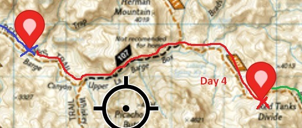
Below is an overview of our hike.
Bluff Springs Trail (235) to Terrapin Trail (234)
Terrapin Trail (234) to Dutchman's Trail (104)
Dutchman's Trail (104) to Red Tanks Trail (107)
Red Tanks Trail (107) to Coffee Flats Trail (108)
Coffee Flats Trail (108) to Dutchman's Trail (104)

As an FYI, water on this trip water was in abundance due to all the recent rains. There was water flowing even on top of Ren Tanks Divide.
Day 1 - Snow!
It seemed my attempt at leaving the white stuff behind with 4-hour flight to the southwest didn't work. When we arrived at the trail head this is what welcomed us.

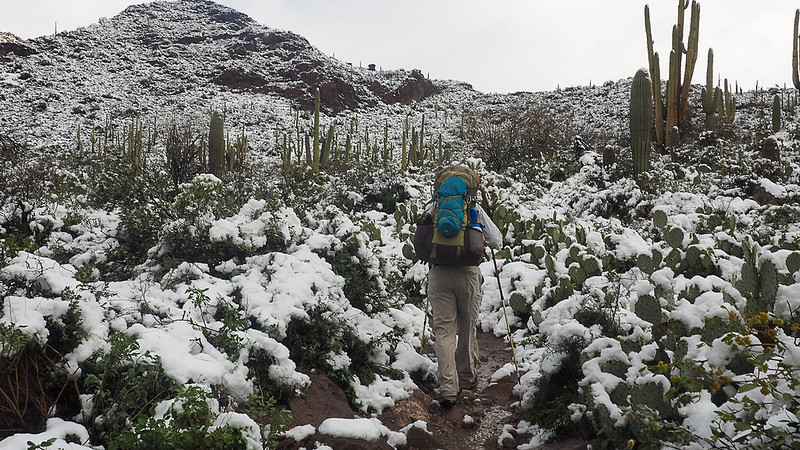
After about 3 or 4 hours and stopping for a break a day hiker walked up to us and thanked us for our tracks in the snow as the trail was difficult to follow. Admittedly we were more or less making educated guesses to the location of the trial. At times the trail and creek became one.

As the day drew on and sun came out I realized couple of things. As the sun shone off the snow I soon discovered that I had forgotten my clip-on sun shades for my glasses. I ended up doing a lot of squinting that afternoon. The other thing was that never once did it enter my mind that the trail conditions would end up being slush.

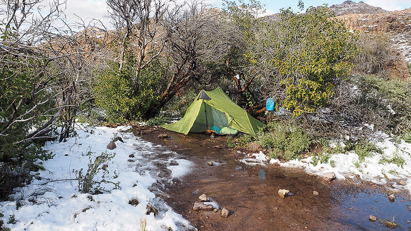
Later on, during the day we realized that we probably wouldn't make it to a "good" camping spot (no flat spots on this section of trail) so we started watching for any place that was large enough for a couple of tents. This was closest I've ever come to pitching my tent in the snow. No judging the pitch of my tent (green one), please!. It was an awkward place to put my tent.

Day 2 - Creepy Backpacks
Woke up to frost on our tents and under the watchful tower of Weaver's Needle.


This day was kind of un-eventful. The sun eventually melted the rest of the snow left over from yesterday. I simply settled into the slow ups and slower downs (I hate going downhill) and enjoyed the scenery that I rarely get to see. The extra water from the recent rains and snow melt had us make some interesting creek crossings.


Not too far from where we decided to camp for the evening we came across these very deteriorated abandoned backpacks. Just happy it there was only backpacks here.

This evening while finishing up supper two hikers passed by and greeted them and they stopped for a short conversation. Come to find out they were through hiking the Grand Enchantment Trail and it was their 2nd day. If "Fire" and "Thomas" read this for some reason it was good meeting you. "Fire" made the claim that his base weight was 6lbs but since I didn't have a scale nearby I didn't ask him to prove it.
Day 3 - Big Sky and Big Views

Woke up to frost on the tent again. Not too far down the trail had to make one of the countless stream crossings of this hike.

Today was more or less level hiking and not much to report for this day expect maybe the first encounter of this trip with catclaw. However, this day we scored what I considered one of the best campsites of the trip (not the best though). Huge open sky for a nice look at the stars and moon.


Day 4 - Upper La Barge Box Canyon
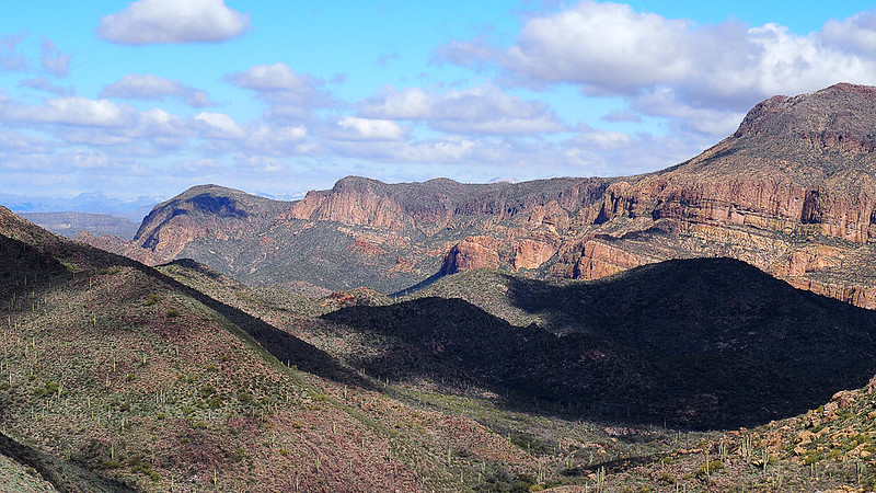
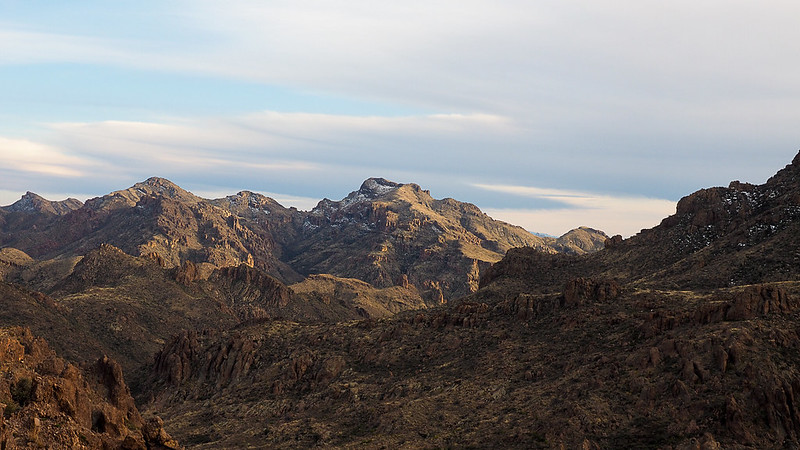
This day was probably the climax of the hike for me. However, while it was cold on waking there was no frost this morning. Here is a view out of my tent looking towards La Barge Box Canyon.

Not too long into the hike we had to make a particularly stressful (for me anyway) creek crossing. The rocks were placed just beyond what I considered safe distances for jumping with a pack on. The current was rather strong and I didn't feel like going for a swim but in the end I made the leap with no issues other than some adrenaline pumping through my system for a few minutes afterward and a wet toe. Then we started our entrance into the Upper La Barge Canyon.

This part of the day was the best and worst. The hike was "difficult" but very doable if that makes sense and had some incredible views. Not of grand vistas but a deep and rugged canyon. And my photo/s don't do it justice. If you get the chance to do this section of trail I highly recommend it but it did give my flat lander legs a thorough workout.

After we exited the La Barge Canyon and turned SE, this section of the Red Tanks Trail received the name of "Catclaw Alley", almost all the way to Coffee Flats Trail.

Also the recent flooding from the rains made the trail a challenge to follow but wasn't horrible. Then late in the afternoon we finally got to our destination for camp. What I'd call pass is labeled "Red Tanks Divide". We planned on dry camping but even on top of the divide there was a small stream trickling. This place provided spectacular views and was a good place to end the day.
That evening just before bed the back of my hand developed a severe pain. Almost like I had been stung by 20 bees at once. There wasn't much I could do so took some ibuprofen and doctored it up with a little activated charcoal. Whether the charcoal helped or not I won't know but by morning all was well..

Day 5 - Who Needs a Trail When You can Hike a Creek Instead?
Today we woke up to much warmer temperatures and good views.

After breakfast and throwing our packs the trail immediately did a nose dive into the drainage. We followed this very steep decent for about a quarter of a mile. The only thing I could think was that I was thankful we could take our time and that I wasn't hiking it in the other direction.
After exiting the tunnel of Catclaw and trail crossed the stream so many times we abandoned the routine of taking off shoes & socks and simply walked the creek. Most places there wasn't a trail anyway and the creek felt better and was any easier hike.


We hiked this way until the creek from Fraser Canyon joined us. Here we decided to call it day and found a very pleasant spot under a couple of tall trees and on lone cactus.

Day 6 - Day of Flowers

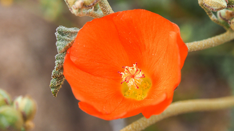
Again, woke up to much warmer temps and the sound of the creek running nearby. It was more of the same as there was more creek than trail. Today we called it a very short day and decided to stop by early afternoon. This gave me some time to photograph some desert flowers that I was hoping to do.


We pitched our tents under some kind of small tree. Not far away was an old windmill that while it no longer pumped water it was able to give of some very eerie sounds at night when it slowly turned in the breeze that kicked up once in a while.


Day 7 – On the Home Stretch
Our last day was a fairly flat day that meandered back to the Peralta Trail Head through the varied cacti. I heard more birds this day than all other days combined. Just wished I knew my AZ birds better. One I identified later as some kind of Thrush by listening to calls on the Audubon app.


Now with the civilization back in our sights we were ready to be back as all our food had been exhausted. It was the first time that I planned exactly my food without carry extra. The End!!

First of all, this trip was by no means a high mileage trip. I haven't yet attempted to guess at the mileage. As a matter of fact, I'm guessing a strong fit hiker could do what we did in 2 or 3 days. However, for me and my hiking partner its more about taking time to enjoy just being outdoors and being able to hike with a good friend. It truly is, for me, more about enjoying nature and the scenery. With that Caveat, out of the way let's continue.
As a side note, the evening before the hike I looked at the weather and told my friend that it looks like it’s snowing not far from here. He kindly took note but made some kind of comment about elevation. This will be relevant as you continue to read.
Below is an overview of our hike.
Bluff Springs Trail (235) to Terrapin Trail (234)
Terrapin Trail (234) to Dutchman's Trail (104)
Dutchman's Trail (104) to Red Tanks Trail (107)
Red Tanks Trail (107) to Coffee Flats Trail (108)
Coffee Flats Trail (108) to Dutchman's Trail (104)
As an FYI, water on this trip water was in abundance due to all the recent rains. There was water flowing even on top of Ren Tanks Divide.
Day 1 - Snow!
It seemed my attempt at leaving the white stuff behind with 4-hour flight to the southwest didn't work. When we arrived at the trail head this is what welcomed us.
After about 3 or 4 hours and stopping for a break a day hiker walked up to us and thanked us for our tracks in the snow as the trail was difficult to follow. Admittedly we were more or less making educated guesses to the location of the trial. At times the trail and creek became one.
As the day drew on and sun came out I realized couple of things. As the sun shone off the snow I soon discovered that I had forgotten my clip-on sun shades for my glasses. I ended up doing a lot of squinting that afternoon. The other thing was that never once did it enter my mind that the trail conditions would end up being slush.
Later on, during the day we realized that we probably wouldn't make it to a "good" camping spot (no flat spots on this section of trail) so we started watching for any place that was large enough for a couple of tents. This was closest I've ever come to pitching my tent in the snow. No judging the pitch of my tent (green one), please!. It was an awkward place to put my tent.
Day 2 - Creepy Backpacks
Woke up to frost on our tents and under the watchful tower of Weaver's Needle.
This day was kind of un-eventful. The sun eventually melted the rest of the snow left over from yesterday. I simply settled into the slow ups and slower downs (I hate going downhill) and enjoyed the scenery that I rarely get to see. The extra water from the recent rains and snow melt had us make some interesting creek crossings.
Not too far from where we decided to camp for the evening we came across these very deteriorated abandoned backpacks. Just happy it there was only backpacks here.
This evening while finishing up supper two hikers passed by and greeted them and they stopped for a short conversation. Come to find out they were through hiking the Grand Enchantment Trail and it was their 2nd day. If "Fire" and "Thomas" read this for some reason it was good meeting you. "Fire" made the claim that his base weight was 6lbs but since I didn't have a scale nearby I didn't ask him to prove it.
Day 3 - Big Sky and Big Views
Woke up to frost on the tent again. Not too far down the trail had to make one of the countless stream crossings of this hike.
Today was more or less level hiking and not much to report for this day expect maybe the first encounter of this trip with catclaw. However, this day we scored what I considered one of the best campsites of the trip (not the best though). Huge open sky for a nice look at the stars and moon.
Day 4 - Upper La Barge Box Canyon
This day was probably the climax of the hike for me. However, while it was cold on waking there was no frost this morning. Here is a view out of my tent looking towards La Barge Box Canyon.
Not too long into the hike we had to make a particularly stressful (for me anyway) creek crossing. The rocks were placed just beyond what I considered safe distances for jumping with a pack on. The current was rather strong and I didn't feel like going for a swim but in the end I made the leap with no issues other than some adrenaline pumping through my system for a few minutes afterward and a wet toe. Then we started our entrance into the Upper La Barge Canyon.
This part of the day was the best and worst. The hike was "difficult" but very doable if that makes sense and had some incredible views. Not of grand vistas but a deep and rugged canyon. And my photo/s don't do it justice. If you get the chance to do this section of trail I highly recommend it but it did give my flat lander legs a thorough workout.
After we exited the La Barge Canyon and turned SE, this section of the Red Tanks Trail received the name of "Catclaw Alley", almost all the way to Coffee Flats Trail.
Also the recent flooding from the rains made the trail a challenge to follow but wasn't horrible. Then late in the afternoon we finally got to our destination for camp. What I'd call pass is labeled "Red Tanks Divide". We planned on dry camping but even on top of the divide there was a small stream trickling. This place provided spectacular views and was a good place to end the day.
That evening just before bed the back of my hand developed a severe pain. Almost like I had been stung by 20 bees at once. There wasn't much I could do so took some ibuprofen and doctored it up with a little activated charcoal. Whether the charcoal helped or not I won't know but by morning all was well..
Day 5 - Who Needs a Trail When You can Hike a Creek Instead?
Today we woke up to much warmer temperatures and good views.
After breakfast and throwing our packs the trail immediately did a nose dive into the drainage. We followed this very steep decent for about a quarter of a mile. The only thing I could think was that I was thankful we could take our time and that I wasn't hiking it in the other direction.
After exiting the tunnel of Catclaw and trail crossed the stream so many times we abandoned the routine of taking off shoes & socks and simply walked the creek. Most places there wasn't a trail anyway and the creek felt better and was any easier hike.
We hiked this way until the creek from Fraser Canyon joined us. Here we decided to call it day and found a very pleasant spot under a couple of tall trees and on lone cactus.
Day 6 - Day of Flowers
Again, woke up to much warmer temps and the sound of the creek running nearby. It was more of the same as there was more creek than trail. Today we called it a very short day and decided to stop by early afternoon. This gave me some time to photograph some desert flowers that I was hoping to do.
We pitched our tents under some kind of small tree. Not far away was an old windmill that while it no longer pumped water it was able to give of some very eerie sounds at night when it slowly turned in the breeze that kicked up once in a while.
Day 7 – On the Home Stretch
Our last day was a fairly flat day that meandered back to the Peralta Trail Head through the varied cacti. I heard more birds this day than all other days combined. Just wished I knew my AZ birds better. One I identified later as some kind of Thrush by listening to calls on the Audubon app.
Now with the civilization back in our sights we were ready to be back as all our food had been exhausted. It was the first time that I planned exactly my food without carry extra. The End!!


