|
|
Post by tipiwalter on Jan 26, 2016 7:21:33 GMT -8
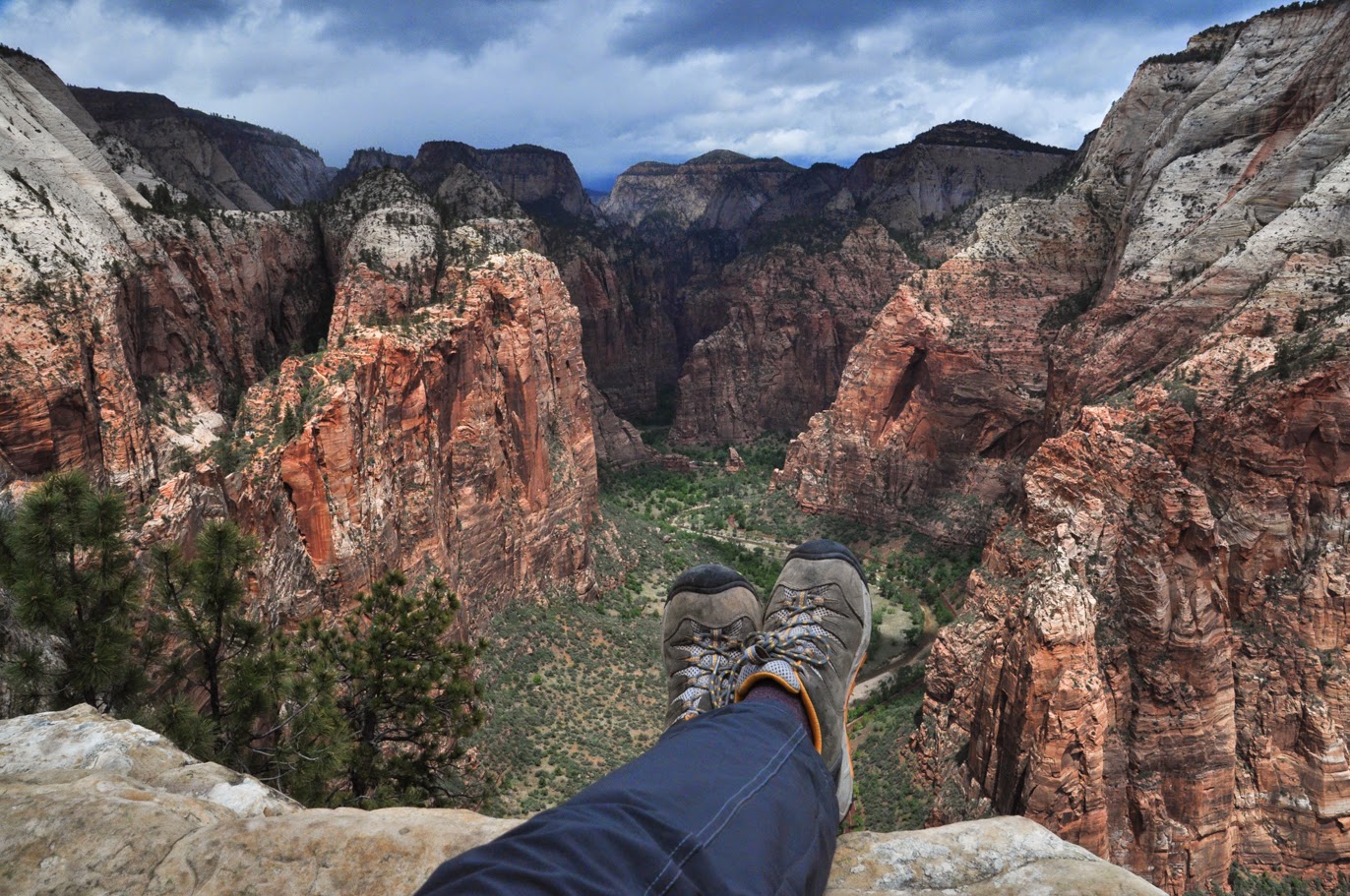
I just returned from a 21 day backpacking trip into the mountains of Tennessee and North Carolina and figure I'll post an abbreviated trip report here. I started in the Citico Creek wilderness of TN and entered the Slickrock wilderness of NC and then climbed Flats Mt and passed thru the Brushy Ridge backcountry of TN to end my trip in the Bald River Gorge wilderness of TN. My pack weight started with full winter kit including microspikes at 95 lbs---including 45 lbs of food and 44 ozs of white gas and several copied internet "book rolls" (7) along with the usual winter kit of down parka and two sleeping pads and down mittens and down pants etc. My sleeping bag is a WM Puma rated at -15F. For full trip pics see here--- tipiwalter.smugmug.com/Backpack-2016-Trips-171/21-Days-in-January/While I didn't see a lot of snow and missed winterstorm Jonas by a day, I did see many cold mornings from 10F down to 0F on Flats Mt and got a little snow towards the end of the trip.  My trip begins in Beehouse Gap and a half mile hike down here to Citico Creek and the low water bridge crossing to get to the other side to begin the climb up the Rocky Flats trail---I'm on it now and looking back down to the creek.  I spend several days on the Rocky Flats trail and set up my tent in Chimney Camp. I'm wearing my Arcteryx Delta fleece jacket and my Icebreaker merino leggings with a Patagonia Thermal weight hoody top under the Arcteryx.  On the morning of Day 5 it's about 15F and obvious from the shape of the curled up rhododendron leaves, always a sign of how cold it is in the Southeast forests.  I leave Rocky Flats trail and camp one night on Mill Branch trail and then climb up the Crowder Branch trail and run into this wonderful blowdown but I cut a left side step-over which only requires a backpacker to step up a couple logs and over the mess.  Midway up Crowder Branch trail I set up my Hilleberg Keron tent and call it a day. Beyond this camp the trail gets seriously steep with some severe blowdowns.  On Day 6 I begin my climb up Crowder Branch and hit one of dozens of blowdowns so I dump the pack and pull out the folding saw and get to work.  All backpackers should help clear the trail as they hike---and so Voila! Blowdown cleared!! |
|
|
|
Post by tipiwalter on Jan 26, 2016 7:39:22 GMT -8
 Day 7 is a typically cold January day with butt cold rain at around 35F so I cover the pack and finished Crowder Branch and climb hard up Fodderstack Ridge to this exposed campsite I call Horn in the West. It is very windy and requires all 14 pegs for my Hilleberg tent. The freedom to camp at such places is why I carry a four season tent---bring on the wind!  On Day 8 I leave the Horn in a light cold rain and backtrack south on Fodderstack Ridge to this open campsite where I junction with the Big Stack Gap trail #139 which is a 2 mile drop to Slickrock Creek in NC and a loss of 1,500 feet in elevation. My pack is a Mystery Ranch G7000 which easily holds 21 days worth of winter gear.  After a good hike down the mountain I'm in North Carolina and reach the mighty Slickrock Creek which must be crossed to get to my Day 8 campsite.  The morning of Day 10 sees my so far coldest morning at 10F so I pack up and leave Slickrock Creek and climb the Big Fat trail up a thousand feet in 1.5 miles to Big Fat Gap. It's a cold hike on a mostly shady trail.  On Day 11 I begin my tough 2,000 foot climb up Hangover Mt and spend all day hiking in a butt cold windchill with ambient temps at around 10F---it's 1F on Mt LeConte which isn't too far away from me. I usually like to take off-pack reststops once an hour but it's too cold with 40mph winds so I don't stop and keep moving.  I owe my feet to these Zamberlan winter boots---Vioz Plus GTX all leather. When frozen solid I could still get my feet inside and laced with no problem and they never leaked in shallow creek crossings up to 6-7 inches. All hail goretex lined boots !! And they were a huge step up in quality from my sorry Asolo boots.  As I pull my 3,000 foot climb up to the top of Hangover Mt in NC, I run into this nasty blowdown which requires 30 minutes of off-pack trailwork with my saw and pruners.  Trailwork finished!!!! Now I can get thru the mess with my giant Red Strap-On Pack. |
|
|
|
Post by tipiwalter on Jan 26, 2016 7:49:12 GMT -8
 As I climb up Hangover Mt to 5,000 feet I see evidence of this morning's cold 10F temps by the frozen nature of the trail. This is why we bring Kahtoola microspikes.  It's an arduous 3,000 foot climb up to Hangover Mt with a 75-85 lb pack but I'm getting closer and stop in the heath tunnel for a break. Not a long break cuz it's damn cold.  Of course as I keep climbing up Hangover Mt I pass by wonderfully ass-cold sculptures put in by Miss Nature, the Queen of the Cold and the Trees.  I pass over Hangover Mt and climb to Haoe Peak at around 5,300 feet and stop for a break in the action.  I spend the next several days above 5,000 feet and by Day 15 I'm ready to bail off the mountain and get to lower ground in preparation for a severe cold snap coming in with 0F temps (Mt LeConte gets -7F). So I leave Bob Mt here and take Fodderstack Ridge back into the Citico wilderness on the Pine Ridge trail down to Warden's Field (the low water bridge across Citico Creek) and begin my climb up Flats Mt.  Day 16 begins a very cold day of backpacking off Pine Ridge trail (above) and up to Flats Mt on a long haul trek and another gain of almost 3,000 feet in elevation.  As I keep climbing up Flats Mt and look over to where I was the night before---Bob Mt---and see my coldest night approaching which becomes 0F atop Flats Mt at 4,000 feet. |
|
|
|
Post by tipiwalter on Jan 26, 2016 8:00:33 GMT -8
 My coldest morning is Day 18 (January 19) at 0F as I leave Flats Mt and cross the Cherohala Skyway to connect to the Long Branch trail in the Brushy Ridge backcountry. It's -7F on Mt LeConte so it's cold as I rarely backpack in my Arcteryx fleece jacket.  On the cold morning of Day 19 I wake up on the Long Branch trail near the bottom and look out my tent vestibule to the small trash fire I started to burn the last of my books.  I leave Long Branch and hike along North River in TN for awhile and find a rare sight in TN: A partially frozen large river. The North River hike takes me to the junction with the even bigger Tellico River.  I make it to Tellico River and follow it down for about 4 miles to the entrance to the Bald River Gorge wilderness.  Near the entrance to Bald River wilderness I pass by Baby Falls on the Tellico River.  Once in Bald River wilderness I set up about a mile inside and get my first real snow of the trip---a light dusting although temps still stay low for many days and I'm getting tired of it but by now I have only a couple days left of the trip.  On Day 20 I leave Bald River wilderness and hitch a ride with this friendly fellow down the river road to a drop off point near Old Furnace road which I climb to a stealth camping site for my last night of the trip. His ride saves me an 8 mile roadwalk.  My last night is a stealth site off Old Furnace road in continuing wet and cold. This is getting old.  On Day 21 I leave Old Furnace road and hike down to Tellico River and to the Beach Drive-In restaurant to wait for my ride in a butt cold rain but I'm protected by a roof!! Yippee. So ends Trip 171. |
|
|
|
Post by tipiwalter on Jan 26, 2016 8:04:30 GMT -8
Oh and btw: I DIDN'T SEE A SINGLE FELLOW BACKPACKER IN 21 DAYS!!
|
|
rpcv
Trail Wise!
Posts: 120
|
Post by rpcv on Jan 26, 2016 9:32:33 GMT -8
Great trip report and photos. Thank you for sharing. That is a long time to be out in that kind of cold, but it looks like you had good time.
|
|
|
|
Post by tipiwalter on Jan 26, 2016 10:07:29 GMT -8
The Southeast winter mountains have a way of eating into my bones with high humidity and low temps---Rain at 35F followed by fog and cold snaps to 10F or 0F. When it warms up we're back to freezing sleet and rain at 25F. The cold eats into my torso and long nights in the tent get weird. But at least I'm out.
|
|
|
|
Post by trinity on Jan 27, 2016 5:02:37 GMT -8
Great report, as always. The fact that you went three weeks without encountering another backpacker says it all. Thanks also for adding in some gear commentary, I appreciate that.
|
|
BlueBear
Trail Wise!
@GoBlueHiker
Posts: 3,224
|
Post by BlueBear on Jan 27, 2016 12:02:55 GMT -8
What Trinity said.  ^^ Great trip, thanks for the report. |
|
toejam
Trail Wise!
Hiking to raise awareness
Posts: 1,795 
|
Post by toejam on Feb 1, 2016 7:52:33 GMT -8
I think you're crazy, but it sounds like you are having fun and connecting with the wilderness, which is all that matters. That's an admirable accomplishment and I'm glad you shared it with us.
|
|
toejam
Trail Wise!
Hiking to raise awareness
Posts: 1,795
|
Post by toejam on Feb 1, 2016 7:58:33 GMT -8
As a guy who cuts a lot of blowdown out of trails, I want to recommend the Silky Bigboy folding saw. They seem to start and stay sharper than other similar saws. Get the one with the most aggressive teeth, of course. |
|
|
|
Post by tipiwalter on Feb 1, 2016 8:40:04 GMT -8
As a guy who cuts a lot of blowdown out of trails, I want to recommend the Silky Bigboy folding saw. They seem to start and stay sharper than other similar saws. Get the one with the most aggressive teeth, of course. It's funny you should mention this as my buddy Randy had the same exact saw and used it with me on a blowdown on the Rocky Flats trail on this trip. I tried it too and compared it to my Corona $20 folding saw and found it to be heavier and a little bulkier but both shared the same cutting edge teeth technology as far as I could tell. I like the Corona as it's available locally at Lowes hardware and I buy a new one once a year as the teeth on these saws cannot be sharpened.  Randy dropped his Silky saw inadvertently when he was leaving the area and I found it and stashed it for him to pick up later. |
|
mk
Trail Wise!
North Texas
Posts: 1,217 
|
Post by mk on Feb 1, 2016 11:58:46 GMT -8
My pack weight started with full winter kit including microspikes at 95 lbs I like to imagine that at about Day 15, you're practically skipping up the trail after taking off some of that food and fuel weight. Great photos and report, Tipi. I really enjoy how you describe the cold ... |
|
|
|
Post by tipiwalter on Feb 1, 2016 12:36:13 GMT -8
I like to imagine that at about Day 15, you're practically skipping up the trail after taking off some of that food and fuel weight. Great photos and report, Tipi. I really enjoy how you describe the cold ... Yes, my pack does get significantly lighter as the trip progresses, obviously. I literally eat my way to Pack Relief. That being said, I have to say the first step out of the car on Day 1 with a 90 lb pack is the best step of the whole trip and the best feeling of the whole trip. Nobody has to carry my crap but me and I have a deranged desire to carry too much reading material on my trips as I like to read in camp and cannot seem to do any significant reading at home so I need a tent and solitude for the act. What do I read? ** Find interesting stuff on the World Wide Interwad and bookmark it. ** Print out the neat stuff on 70 pages of typing paper. ** Reverse paper and print out more stuff on the other side, thereby making a stack of 70 pages with 140 both-sides of reading. ** Roll each "book" into tight tube and rubber band together. I usually take around 7 to 12 of these book rolls and the weight is significant but it is all burned after reading.  Here's a typical trip load of book rolls---they are heavy but quickly burned. |
|
|
|
Post by Coolkat on Feb 1, 2016 12:46:06 GMT -8
I usually take around 7 to 12 of these book rolls and the weight is significant but it is all burned after reading. This is why I take my Nook Glow that weighs in at about 6.2 oz. Right now it has over 400 books on it and if I want to read something off the internet than I turn it into a pdf file and copy it to my Nook. It has it's own light and battery will last for weeks. However, I'm not sure how it would have tolerated the cold temperatures you experienced. |
|