GaliWalker
Trail Wise!
Have camera, will use.
Posts: 3,800 
|
Post by GaliWalker on Jul 23, 2015 12:02:25 GMT -8
Hike #1, in my personal Top-10...
Top-10 hikes:
10: Lake Ida – Lake Edna loop (Washington)
9: Chesler Park and Druid Arch (Utah)
8: Presidential Traverse (New Hampshire)
7: Half Dome (California)
6: Pea Soup Lake (Washington)
5: Grand Canyon (Arizona)
4: Enchantments (Washington)
3: Nanga Parbat bc, Fairy Meadows (Himalayas)
2: Snow Lake (Karakorams)
1: Concordia and K2 basecamp (Karakorams)
July, 2013: Throne room of the mountain gods* Concordia, Central Karakorams, Pakistan K2 and Broad Peak from Concordia* Title courtesy of Galen RowellPart I: Beginnings K2 and Broad Peak from Concordia* Title courtesy of Galen RowellPart I: BeginningsSome dreams are so precious that you nurture them in secret. You dare not think about them directly, before the time is right, lest they evaporate, leaving you with dashed hopes. So, I kept my childhood dream of gazing upon K2 - the world's second highest peak - locked up securely. This past winter, while planning my big trip for the summer, I decided that it was finally time to realize my dream and began to do some homework. In February, after my first set of plans fell apart, I regrouped and signed up with a Pakistani adventure tourism company called Vertical Explorers, who sported a stellar reputation. One additional advantage they had was that they were based in Skardu, which is the portal town to the Karakoram peaks; I figured that this gave them a much better handle on local customs compared to other competing companies. All spring and early summer was spent building up my fitness and toughening my feet on long grueling training hikes. Two weeks before my departure for Pakistan, and just when I was feeling good about the trip, the unthinkable happened: eleven climbers and support staff were senselessly murdered at one of Nanga Parbat's base camps. After a lot of soul searching and discussions with my wife, as well as with Vertical Explorers, I decided to go ahead with the trip. One major factor was that the Concordia trek was in the Karakorams, a much safer location than the Himalayan Nanga Parbat (even though the spots were somewhat close). This safety is mainly due to the presence of the Pakistan Army, whose helicopters regularly fly the Baltoro Glacier corridor, which is what I was going to use to access Concordia. The only trouble spot would be on the drive from Islamabad to Skardu, when I'd have to pass through Nanga Parbat's foothills. July 6-11: Arrival and Taliban counter-measuresA long set of flights from Pittsburgh to Islamabad deposited my jet-lagged carcass in Pakistan on a stormy monsoon morning. I was hopeful that this bad weather would be confined to Islamabad - the Karakorams are in the rain shadow of the Himalayas and reputedly sheltered from the brunt of the monsoons. After a couple of days in Islamabad meeting family and old friends, early morning on the 10th I met up with the rest of my trekking group, seven Chinese and one German. We all packed ourselves into a minibus and were on the road by 5:20am. Our destination was the town of Chilas, which was smack dab in the middle of the region most linked with terrorism related violence. The drive started off on good roads, taking us through a vibrant green countryside. A few hours into the drive we passed through the infamous town of Abbotabad (Bin Laden's final hideout), which elicited excitement and a few grins. The hills surrounding us were wreathed in mist, all quite beautiful and serene - not a helicopter gunship to be seen! Terraced fields kept us company as we proceeded northwards, steadily making our way towards the famous KKH (Karakoram Highway), carved out of the crumbly mountainside at great cost of human life, both Pakistani and Chinese. Just shy of the KKH I got my first surprise of the trip. From this point on, until we were past the 'danger zone', we were provided with either a police escort or an armed policeman, who would join us in our crowded minibus. Periodically, the personnel were replaced as we passed from one jurisdiction to the next. I had mixed feelings about this: on the one hand I felt safer while on the other I felt even more apprehensive than I had originally, since it made the danger from the Taliban seem that much more real. We stayed the night in Besham, well short of our target destination of Chilas, due to delays caused by having to frequently replace our escort. We were all quite tired; the road surface had long since deteriorated alarmingly and our cramped vehicle was none too comfortable. The next day would be even harder. By now the KKH was awful. Large tracts of it were in a constant state of repair, due to frequent landslides. As we soldiered on the gentle green scenery of the day before was replaced by desolate and rugged terrain. We were paralleling the river Indus, which cuts through the length of Pakistan from north to south. At this stage of its life cycle it was a slate grey snake, slithering through a narrow gorge. A series of 1000-4000ft tall cliffs loomed claustrophobically overhead, in concentric shelves, stacked like dominos. I could imagine them standing at the ready to collapse, begging for a chance to bury us alive. Just before passing through Chilas the valley opened up. A little after Chilas was the viewpoint for Nanga Parbat, the world's ninth highest peak. Disappointedly, clouds obscured most of the mountain, including the summit. The last handful of hours of our drive, for which a police escort was no longer deemed necessary, was an exercise in patience. 15 tiring hours since starting, at the advanced hour of 11:00pm, we finally staggered into Skardu (elevation 8,000ft) and our hotel, where we slept the sleep of the dead. July 12: End of the roadDay 3 of the drive was one I was looking forward to. The minibus had been ditched and replaced by two jeeps. It took a while for us to get going though, since we had to go through a registration/briefing process with the Pakistan government first. The jeep drive took us north through the beautiful Shigar valley. We passed one pretty village after the other, little islands of lush greenery, glittering like jewels in the otherwise bleak landscape. To offset the hardship of living in this land of extremes the villagers had seemingly impossibly distilled little pools of paradise for themselves, as if making wine from water.  Start of the Shigar Valley Start of the Shigar Valley   Island of greenery Island of greeneryHalfway through our drive we left the Shigar valley, now travelling eastward alongside the awe inspiring Braldu River. The Braldu River was a seething torrent, chock full of rapids and up to 50ft tall fountains of spray. Its origin was the Baltoro Glacier, atop which we were to spend a major part of our trek. By now the jeep ride had become scary - near vertical cliffs on one side, and the powerful Braldu on the other. The tightly winding 'road' wasn't much wider than the width of the jeep, making each turn an adventure.  Near the town of Apiligon we saw an incredible sight: the entire Braldu River was somehow being funneled through a narrow chasm, only a few yards across. Unfortunately, we did not have the time to hike down to the constriction for a better view.  Constriction ConstrictionFinally, around 7:00pm, we reached the lovely, lovely town of Askole (elevation 10,000ft) and the end of the road. From now on we'd be sleeping in tents and hiking.  Nearing Askole Nearing Askole Askole resident Askole resident Askole Askole
|
|
GaliWalker
Trail Wise!
Have camera, will use.
Posts: 3,800
|
Post by GaliWalker on Jul 23, 2015 12:02:44 GMT -8
Part II: Hiking inJuly 13: Askole to JolaExcitement! The long drive was over and I was chomping at the bit to get started with the hiking. Since I've been a solo hiker for a long time there were some nerves on my part, regarding how my fitness level and hiking speed would compare to the others in my party, all strangers to me. The day began with a 6:00am breakfast. As we ate, our tents were packed up by the support staff of porters and cooks, numbering more than twenty! Each of us had been assigned a personal porter, who would carry most of our gear, leaving us free to hike with a daypack. Mine was loaded with camera gear. It was 6:30am when we started. Quite rapidly, we all spread out and I was soon hiking by myself. The trail paralleled the northern bank of the Braldu River and was mostly flat. However, just when I’d become comfortable a steep vertiginous path would appear to lead me up and over headlands, with the roaring Braldu an uncomfortable presence below. Bakhor Das Peak was a jagged spear to my right, on the far side of the Braldu, but other than that there was no hint of the big mountains to come. As the sun rose higher it started to become uncomfortably hot, but I did not let my pace flag.  After crossing a side stream on a swaying rope bridge I jogged left, away from the Braldu River and towards the mouth of the Biafo Glacier. Magnificent treks lead up this valley, which is deeper than the Grand Canyon and full of wondrous peaks, but this was not part of my itinerary. I continued to follow the main trail as it skirted the mouth of the Biafo Glacier. This was just a jumble of rocks and dirt, with no visible ice, except in the distance further up the valley.   Once done with the Biafo moraine crossing the trail sidled back up to the Braldu River and began to traverse some steep cliffs, to get to the Dumordo River side-valley. The Dumordo River, in early season, can be waded, but this is impossible in mid-summer when the Panmah Glacier fills it full of snow-melt water. The solution is a one mile detour up the sandy Durmodo River valley, where I expected to find a pulley bridge. I had used such bridges before, so wasn't really worried, but was still pleasantly surprised to find a 'proper' rope bridge instead of a precarious pulley bridge. (Upon inquiring, I found that the new bridge had only been set up 2yrs ago.)   Just on the other side of the bridge, 15min away, was the campsite of Jola (elevation 10,500ft), our home for the night. It had taken me 5hrs to get here; I'd soon realize that such short days would be the norm, in order to give us time to get acclimatized. The rest of the day was spent lounging and watching shadows march up the mountains that were ringing us, as the sun went down. July 14: Jola to PaiyuI rose early to watch the sunrise, before joining the others for breakfast. We were all on the trail by 6:15am, walking in the shallows of early morning. Similar to the day before, we soon spread out and I was once again hiking by myself. It was fun watching the shadows lift tantalizingly from the valley floor, like watching a particularly artistic striptease act. Too soon however, I hit the sun and immediately started to get hot. I think that day the temperature exceeded 90F...just energy sapping heat. In compensation, the scenery was quite magnificent.  Bakhor Das Peak Bakhor Das Peak  GaliWalker photographing Bakhor Das Peak GaliWalker photographing Bakhor Das Peak  Braided Braldu Braided BralduOnce again the going was relatively easy. 'Lunch' was taken at 9:30am (!), at the Bardumal campsite, where we were hosted by two genial caretakers. A rudimentary stone hut with three rooms allowed us to take shelter from the heat during lunch, but then it was back out into the blazing sun.  Our host at Bardumal Our host at Bardumal Mohammad Yasin, our assistant cook Mohammad Yasin, our assistant cook   Lunchtime for the trekkers Lunchtime for the trekkersThe post-Bardumal section was harder going. The route took me down to the river bank where sandy sections made for tiresome walking. Periodically, I'd have to scuttle along the rocks lining the river bank to stay above water. The final section before Paiyu was a cruel up-down-up sequence, which was just brutal in the heat.   Paiyu (elevation 11,100ft) was one of the more established campsites on our trek. It was situated at the base of 21,883ft Paiyu Peak, though this was not visible from the campsite. Trees lent welcome shade and soothing greenery to our surroundings. Best of all though were the awesome views of the Cathedral group and Lobsang Spire. Finally, we were getting into the thick of it! The next day, we would make our way onto the Baltoro Glacier and walk amongst the big peaks.   Paiyu Peak shadows Paiyu Peak shadows Cathedral and Lobsang Spire Cathedral and Lobsang Spire Cathedral Cathedral Lobsang Spire Lobsang Spire
|
|
GaliWalker
Trail Wise!
Have camera, will use.
Posts: 3,800
|
Post by GaliWalker on Jul 23, 2015 12:03:02 GMT -8
Part III: On the BaltoroJuly 15: Paiyu to Kho-BurseThe problem with the trek to Concordia is that it takes seemingly forever before you get to see the really big peaks; an exercise in patience and perseverance. Thankfully, after the first two days, by which point you've only got tantalizing glimpses of some of the lesser Karakoram luminaries, on Day-3 all is rectified, as you climb atop the Baltoro Glacier and reach rock climbers' nirvana. This was the day I got to hike on the Baltoro, so it was with a real sense of anticipation that I got ready. We took off from Paiyu at 6:30am and motored along the still mostly flat trail. An hour and a half later was the end of all flatness for the next week as we hit the towering wall that was the face of the Baltoro Glacier. The Braldu River gushed out of a mud encrusted fissure in the ice. The entire glacier was covered with rocks, with almost no white ice showing. As we started to work our way up the steep route that led to the top of the glacier it was mostly just hiking on a really rocky trail, with the occasional talus scramble/rock-hop. We had been told that this day we should stick close to our porters, since the route can be dangerous, especially if you get off track. However, it was a simple matter to stick to one's own pace, since there was almost always a porter in sight ahead of you.  Paiyu Peak spires Paiyu Peak spires   As I crested the face of the glacier I got greeted with a fantastic view of the entire Trango Towers group. For me, seeing and photographing Trango Towers was one of my major goals, second only to seeing K2. The granite spires were magnificent, more than worth the price of admission. Even the intriguingly alien surface of the Baltoro was momentarily forgotten in my excitement.    Eventually, I calmed down and headed off in the direction of the last group of porters I had spotted. Various towers and spires rose up around me on all sides, so that it felt like traversing the maw of a shark with excellent dental work. The route took me from the northern edge of the glacier to its southern end. The going was mostly straight forward, except for one section of exposed ice: a knifelike ridge, only a hand's width wide, with steep drops to god knows where, on either side. The ridge angled downwards, but traction was good (little pieces of gravel were embedded in the ice). I was thankful to make it down safely, under the watchful eye of a couple of our porters.   The rest of the traverse to the far end of the glacier went off without a hitch. At this point we actually left the glacier and picked up a trail on the hillside. More efficient travel took us to the campsite of Liligo, where we had our customary 9:30am 'lunch'. At this time I was able to take in the Baltoro Glacier. God, that thing was monstrous! It stretched off eastwards, as far as the eye could see, a seething tempest of ice and rocks. Nothing was flat: rounded hills and fissures raised and lowered the deck, giving the impression of a troubled sea, frozen in time. Walking that thing was going to be exhausting.  After lunch a short 90min walk along the hillside deposited me at the established campsite of Kho-Burse (12,300ft). It was all straightforward, until the very end. With the campsite in view a pesky maze of a side glacier had to be navigated. We all hurried through this section – as much as we could – since there was much exposed ice, some glacial streams (water flowing in ice channels) and a few crevasses.  Paiyu Peak, still cloudy Paiyu Peak, still cloudy    Kho-Burse was an island of greenery in the otherwise desolate landscape. Waterfalls and streams shimmered down the hillside. The views were magnificent in almost every direction. The only fly in the ointment was the numerous flies that crawled over everything. I have never encountered such disgusting flies – they were not satisfied to just sit on my head, they crawled on my scalp, through my hair! Ugh. Eventually, I gave up and dug out my sleeping bag's mesh storage cover, and wore it over my head.  Hasan, our guide Hasan, our guide  Uli Biaho Tower Uli Biaho Tower  Lobsang SpireJuly 16: Kho-Burse to Urdukas Lobsang SpireJuly 16: Kho-Burse to UrdukasA short but extremely tough day for me. I woke up with chills and knew that the cold I'd been taking a strong line with the past two days had finally got the better of me. Drugged up, I packed my gear, stuffed something down my throat, hoping it would stay there, and started to put one foot in front of the other. I know I walked mostly along the crest of a lateral moraine, I know that I crossed three difficult side glaciers and I know that somehow three hours elapsed. Then I was at Urdukas (13,300ft), where I could rest.          Due to the short day, we all kind of lounged around. Some people seemed to be feeling the effects of altitude (a telltale lack of appetite) but I was too sick to know if I was being affected or not. Around this time I met up with two captains from the Pakistan army, who were also headed to Concordia. One of them was the liaison officer of a climbing group headed for Gasherbrum II, while the other was headed to K2 base camp, where he would be posted for the next month. Both of them dragged me over to their permanent army camp nearby, where I was made to consult a doctor. Antibiotics were doled out.  Tired porters Tired porters     Dwelling above Urdukas Dwelling above Urdukas July 17: Urdukas to Goro Two July 17: Urdukas to Goro TwoHopped up on antibiotics and brimming with bravado, camp chores out of the way, I headed off into the Baltoro, a lifeless desert of ice and rock, ebbing and flowing in ice-dune after dune. From now on we would remain on the glacier until our return to Urdukas.     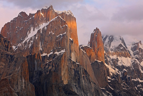    Breaking camp Breaking campThe start was difficult. There were a few crevasses to hurdle and some glacial streams to cross. We relied on our porters to get us through this section. As we got nearer the middle of the Baltoro and things got easier I was comfortable walking my own pace. There was a bit more exposed ice now, but little bits of gravel embedded in the surface made for easy traction.    The views were superb. Now that I was out in the middle of the glacier Urdukas peak stood out in all its glory. Dead ahead, and still a long way away, was Gasherbrum IV, the world's 17th tallest peak at 26,013ft. The most gorgeous of the peaks though, and becoming ever more prominent the further east I hiked, was 25,660ft tall Masherbrum, the world's 24th highest peak.  Urdukas Peak Urdukas PeakOur lunch spot at Goro One was the best viewpoint we'd had so far. It was located right across from Masherbrum and the Yermanendu glacier. The intersection of the Yermanendu and Baltoro Glaciers had resulted in fascinating house-sized seracs. It was incredibly cool walking amongst them as we finished off the day a little further up the Baltoro, at Goro Two (elevation 13,950ft).  Masherbrum Masherbrum     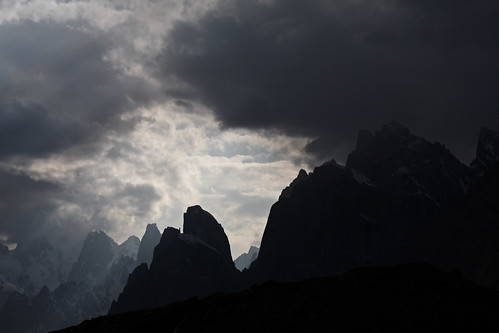 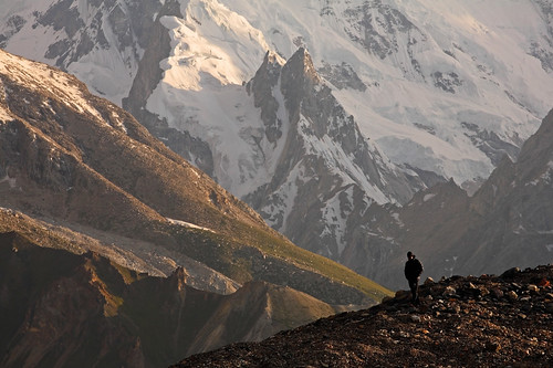 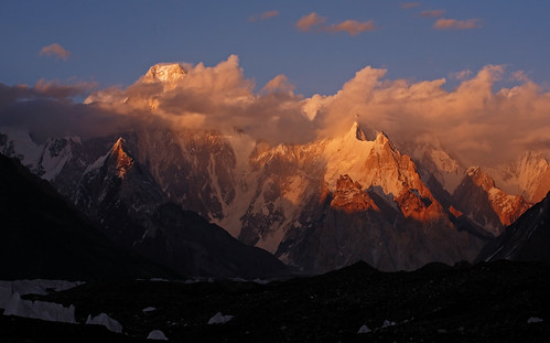  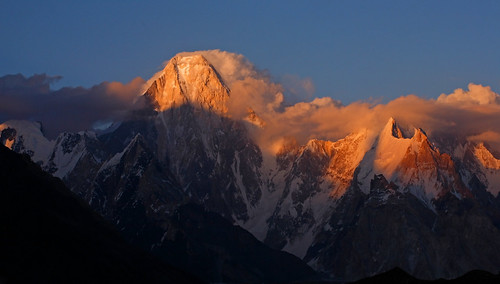 Gasherbrum IV Gasherbrum IV 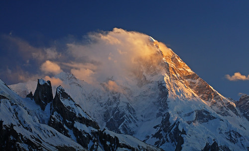 Masherbrum Masherbrum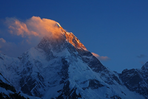 Concordia was now within touching distance, so close I could taste it.
|
|
GaliWalker
Trail Wise!
Have camera, will use.
Posts: 3,800
|
Post by GaliWalker on Jul 23, 2015 12:03:13 GMT -8
Part IV: Throne room of the mountain godsConcordia and K2 base-campJuly 18: Goro Two to ConcordiaThree days of bone-jarring roads and five days of sublime hiking had led to this. Galen Rowel, the great photographer and mountaineer, had dubbed Concordia the "throne room of the mountain gods". This was the day I would enter this room, featuring some of the finest mountain scenery in the world. The excitement, which had been building the past couple of days, was now almost uncontainable. That morning I had a poor night's sleep, due to being too amped up and the temperature being below freezing. Once I got going I deliberately slowed everything down, determined to eke out every bit of enjoyment from the day.  Trango Towers Trango Towers  Urdukas Peak at dawn Urdukas Peak at dawn Masherbrum at dawn Masherbrum at dawnA half hour's hiking got me to the mouth of the valley, at the head of which stood 23,871ft tall Mustagh Tower. Earlier this year I had been enthralled by the excellent book "Summit Fever", which chronicled the third ascent of Mustagh Tower. So, I was really looking forward to my first sight of the peak. Mustagh Tower had originally been made famous by a misleading photo taken edge on from the upper Baltoro, which depicted it as an impregnable tower. Even though I did not get to see the famous 'unclimbable' view the mountain was quite striking, so I spent a good hour wandering up and down the Baltoro trying out different compositions.   Mustagh Tower Mustagh TowerConcordia, elevation 15,500ft, is a T-junction. The Godwin Austin glacier flows southwards from K2, while the Upper Baltoro Glacier flows northwards. The two glaciers collide and merge at Concordia and then flow west as the Baltoro Glacier, which is what we had used for our approach. As I hiked on, heading east towards Concordia and the wall of Gasherbrum IV, marking the end of the T-junction, it seemed that I was making no progress. The scale of the mountains was so huge that what had seemed a stone's throw away turned out to be wishful thinking. Anyway, there were lots of wonders to see: Broad Peak, at 26,414ft the world's twelfth tallest peak, was now in view, to the left of Gasherbrum IV, while Gasherbrum II, at 26,362ft the world's thirteenth highest peak, could be seen peeping out from behind the right shoulder. Disappointingly, Gasherbrum I, at 26,509ft the world's eleventh highest peak, lived up to its second name of Hidden Peak by remaining hidden behind Gasherbrums V and VI.  Hiking past glacial pools, contouring tediously around or over ice-dune after endless dune and jumping the odd crevasse I finally caught sight of a cluster of tents...Concordia, a giant amphitheater, ringed by mountains that soared straight up on all sides. Mitre Peak to my right and Marble Peak to my left formed a giant gateway to the throne room. As I passed through I immediately looked left, up the Godwin Austin glacier, and there stood the pyramid shape of K2. Finally! I couldn't help but lift my arms up high and whoop in exultation.   The rest of the day was spent drinking in the magnificence of K2. I'd periodically drag my eyes away to take in Broad Peak, Gasherbrum IV, Baltoro Kangri (23,990ft) and the lesser peaks, but inexorably my eyes would be dragged back to K2. A thick band of clouds hung stubbornly across the peak, though not the summit, but I wasn't too worried at this stage, since we still had two nights at Concordia.  Marble Peak summit Marble Peak summit   K2 and stubborn clouds K2 and stubborn clouds Broad Peak Broad Peak Broad Peak: Rock and snow Broad Peak: Rock and snow Broad Peak: Dragon's back Broad Peak: Dragon's back Gasherbrum IV Gasherbrum IV GoodnightJuly 19: K2 base camp GoodnightJuly 19: K2 base campA big day, the climax of our trip. The plan was to hike to K2 base camp (elevation 16,500ft) and back, a round trip of 14mi on difficult terrain. This would be our longest day on the trek, estimated to span at least 10hrs. Keeping this in mind, for the first time on the trek I ditched the extra photography gear, only keeping the camera. At my insistence we had a 5:00am start, an hour earlier than normal, just so that we would have a safety margin for the end of the day. Our party also included three porters, without their normal heavy loads, to act as additional guides in case anyone had to turn back. It was cold and inhospitable in the deep early morning shadows of the mountains as we set off. Almost immediately we faced the first obstacle. As we transitioned from the Baltoro to the Godwin Austin Glacier there was a labyrinth of crevasses and swiftly flowing glacial streams. Knowing the way through can potentially shave off hours. We began by walking the crest of an ice dune. This early in the morning the ice was rock hard and traction was not good. Slipping off the crest was a no-no. Next up we had to climb down, off the dune, in a semi-controlled fall. Immediately after this, another ice-dune crossing with a rope to down-climb...then, a series of jumps over crevasses and glacial streams, and a couple of sections of tip-toeing on knife-edged ridges. Abruptly, it all flattened out and the going became easier. We were now on the Godwin Austin glacier.  With the dangerous start out of the way, we all relaxed and spread out. Two of us, plus porter, took the lead, which we'd hold for the rest of the day. We motored on, towards the magnificent pyramid of K2, initially in the shadow of Broad Peak and then in sunshine. Looking back Chogolisa (elevation 25,148ft), also known as Bride Peak, was a gorgeous snowy sight. The great climber Herman Buhl, who has first ascents of two of the world's fourteen 8000m peaks, lost his life on Chogolisa, when he fell through a cornice. 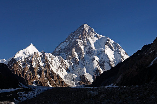 Hiking in Broad Peak's shadow Hiking in Broad Peak's shadow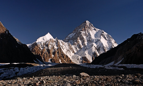   Chogolisa Chogolisa Soon, we reached our halfway point, Broad Peak's base camp, where we decided to wait for the rest of our group to catch up. As we waited we could hear rescue operations being organized for three climbers who had been stuck on Broad Peak's summit, above 8000m, for two nights now. The prognosis wasn't good. We would hear a day later that they had been given up for dead, bringing the deaths on Broad Peak to four for the year. May they rest in peace.  Broad Peak base camp Broad Peak base campThe section from Broad Peak base camp to K2 base camp was a maze of crevasses, glacial streams and pools. We stuck to our guide since it would have been easy to get off track. Most of the elevation gain also took place on this section. I still hadn't completely recovered from the cold that had struck me so badly a few days back – I was perpetually coughing – and it was all I could do to keep up. Curiously, the closer we got to the base camp the less impressive K2 became. From a photographer's point of view, the bright conditions and unaesthetic angles on K2 weren't very appealing. Thankfully, I was wearing my hiker's hat this day so I got my money's worth.   K2's base camp was a busy place, even more so than Concordia. Multicolored tents sprouted like a virulent rash on the glacier. Talking to a Balti high altitude porter - who had summited Gasherbrum II twice as well as Broad Peak, and now hoped to summit K2 - while sipping some tea, I learnt that no one had yet tackled K2 for the year. The high altitude porters were still establishing camps - they had struggled up to camp-2, but with the currently gorgeous weather hoped to have the final two camps set up in the next day or two - while the climbers were still acclimatizing. Summit day was tentatively scheduled to be July 27.  The way back was reasonably straight forward, until the final bit, when we had to transition from the Godwin Austin Glacier back onto the Baltoro. Once again, we had to exercise great care in our footing. In a few places conditions had changed dramatically from the morning, making for some spicy moments. Tired, happy and relieved, we reached Concordia exactly 11hrs after starting. Just in time for me to indulge in some evening photography!   Mitre Peak Mitre Peak  Broad Peak and K2 Broad Peak and K2 K2 K2 Broad Peak Broad Peak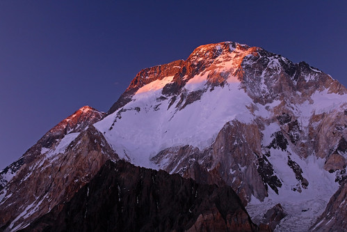 Last light on Broad Peak Last light on Broad Peak Last light on K2 Last light on K2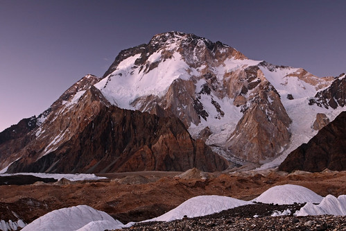 Broad Peak by twilight Broad Peak by twilight Baltoro Kangri Baltoro Kangri Moonrise over Concordia Moonrise over Concordia First light on K2 First light on K2 Sunrise over Gasherbrum IV Sunrise over Gasherbrum IVThe fireworks on our trip were (almost, but not quite) over. All that remained was the small matter of our multi-day return.
|
|
GaliWalker
Trail Wise!
Have camera, will use.
Posts: 3,800
|
Post by GaliWalker on Jul 23, 2015 12:03:23 GMT -8
Part V: OxygenReturn from ConcordiaAll good things must come to an end. With my K2 base camp round trip successfully completed, a mental switch got turned off. Thoughts of a warm shower and sleeping in a bed began to crowd my head, as well as wanting to talk to my wife. I had been out of contact for days and knew that she'd be worried. Unfortunately, accomplishing this was still a number of days off. July 20: Concordia to Goro OneThe thin air wasn't behaving too well with some in our party, plus all of us were anxious to get back anyway. We had long ago decided to shave off one day on the return, especially since we didn't have to worry about maintaining a slow acclimatizing pace anymore. For the first day of the return, we scampered past Goro Two, where we'd camped on our approach, and continued further to Goro One. I had been really keen on staying the night at Goro One, even on the approach, since I considered it second only to Concordia as the top viewpoint on the trek. This was rewarded that evening, when all my photographic fantasies were realized as a magnificent sunset developed over gorgeous Masherbrum.   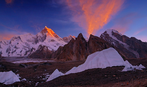  July 21: Goro One to Kho-Burse July 21: Goro One to Kho-BurseWe skipped the campsite of Urdukas, continuing on to Kho-Burse, the land of the clingy flies. It was a surprisingly difficult day for me: I was still coughing continuously from my earlier struggle with a cold. This day I resigned myself to the fact that I would do so till the end of the trek. I was also footsore and completely de-motivated to walk.  Typical knife-edge ridge to negotiate Typical knife-edge ridge to negotiate Our fantastic cooking staff Our fantastic cooking staff  Aisa Khan, my personal porterJuly 22: Kho-Burse to Bardumal Aisa Khan, my personal porterJuly 22: Kho-Burse to BardumalWith oxygen fizzing in our blood, and thoughts of civilization crowding our minds, we decided to shave off another day from our return. Rather than staying at Paiyu, we continued to Bardumal Camp, where I was afforded a touching welcome by the caretaker, whom I had photographed on our approach.  Lovely greenery at Paiyu Lovely greenery at Paiyu  Evening at BardumalJuly 23: Bardumal to Askole Evening at BardumalJuly 23: Bardumal to AskoleIn the homestretch now, off the Baltoro glacier, we fairly flew down the trail, like greyhounds chasing a particularly juicy rabbit. As I entered the little streets of the village of Askole, where I proceeded to promptly get lost, the lush green surroundings were indescribably beautiful. After so many days in ruggedly austere surroundings, this rudimentary slice of civilization seemed like the fanciest place on Earth. That night we gorged on fresh meat, one of the best meals I've had.   Wheat fields...civilization!July 24-26: Askole – Skardu – Chilas - Islamabad Wheat fields...civilization!July 24-26: Askole – Skardu – Chilas - IslamabadOnce again the drive was exhausting, but for some reason, much less so than on the approach. ConclusionThe Karakorams have the finest mountain scenery on the planet. Dramatic spires, rock faces and snowy peaks tower all around you. From both a hiker's and photographer's perspective I've never had so much fun anywhere else, or seen any other place that even comes close. This was the trip to end all trips. My bucket list still has numerous places that I want to see before I hang up my boots, but even if I get to visit none of them, I think I'll be fine. I got to see K2.
Approximate round-trip hiking stats:
- Distance: 114mi
- Elevation gain: 16,000ft
- High point: 16,500ft
- Days: 11
|
|
balzaccom
Trail Wise!
Waiting for spring...
Posts: 4,738
|
Post by balzaccom on Jul 23, 2015 14:36:18 GMT -8
Thanks for posting this here. What a stunning, stunning adventure. And the photos are breathtaking.
We can't match the photos or the adventure, but you've inspired me to post our trips to Peru sometime soon...
|
|
GaliWalker
Trail Wise!
Have camera, will use.
Posts: 3,800
|
Post by GaliWalker on Jul 23, 2015 18:54:11 GMT -8
^ I have yet to make a trip to South America - it's on my bucket list - so post away!
|
|
GaliWalker
Trail Wise!
Have camera, will use.
Posts: 3,800
|
Post by GaliWalker on Feb 28, 2017 12:09:59 GMT -8
I just recently compiled my (current) list of top-10 hikes. This one weighed in at #1. Edited the Trip Report title to reflect this.
|
|


