

Mount Monadnock, New Hampshire (Nov 23, 2023)
Nov 27, 2023 9:09:18 GMT -8
burntfoot, absarokanaut, and 3 more like this
Post by GaliWalker on Nov 27, 2023 9:09:18 GMT -8
Mount Monadnock turkey trot (New Hampshire, Nov/23/2022)
It is an annual tradition for me to head up Mount Monadnock over the Thanksgiving break. Located in southern New Hampshire, the peak is easily accessible from my sister-in-law's house in central Massachusetts, which is where the family gathers over Thanksgiving. This would be my 9th time in the past 10yrs; only 2020 was skipped due to COVID-19 precautions. While I prefer to get the hike out of the way on Wednesday, before the festivities start, this year was a bit different. Steady rain in Massachusetts from Tuesday evening through Wednesday morning, which I knew would be snow in New Hampshire, forced me to delay the trip to the morning of Thanksgiving Day.
I reached the Monadnock State Park headquarters parking lot around 6:15am. There were about a dozen cars there already. The car's temperature gauge read 35°F, but a ~20mph wind was whistling through the parking lot. I knew that the 20mph wind would be far stronger atop the mountain.
I was on my way up the White Dot Trail by 6:30am. In 0.8mi, I branched off onto the Cascade Link trail. The Cascade Link trail meandered for a bit through flattish forest. Due to the recent precipitation a series of streams paralleled the trail for this section. Not that long after, the gradient increased significantly, as I side-hilled across a steep slope. A series of short scrambles over ledges, and corridors of damp, up-sloping rock slabs led me out of the woods. For a while I did without additional traction, but the thin layer of snow on the rock slabs was making for tricky footing, so I put on my microspikes. Travel immediately because less stressful. Not long afterwards I reached the Pumpelly Trail atop the northeast ridge.
As anticipated, as soon as I hit the northeast ridge I was blasted by a freezing cold wind. It was a constant ~40mph, and much worse with the occasional gust. At one point I took my backpack off to get at something inside, and the 15lb backpack was nearly snatched out of my hands as if it weighed nothing. As I made my way up towards the summit, I had to fight to keep myself from being knocked off my feet at numerous points.

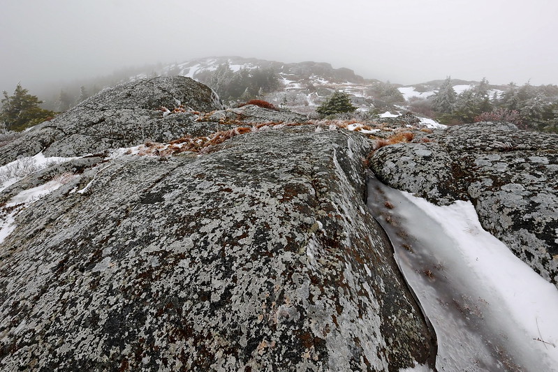
A snowy northeast ridge, just past the intersection of the Cascade Link and Pumpelly Trail


Due to thick mist, there were no views. In fact, when I reached the summit I was slightly taken aback, because I'd thought there was still an additional hill or two to climb.
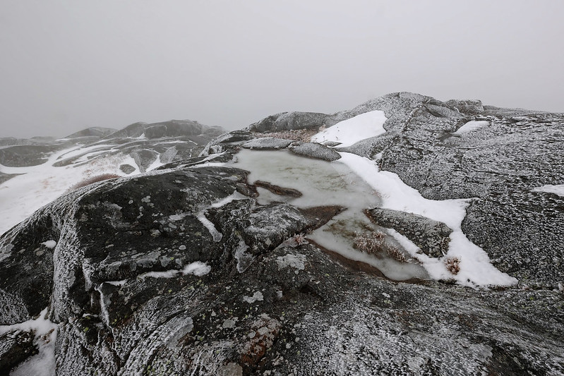
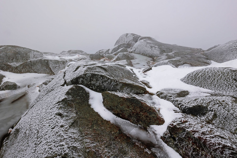
Summit
From the summit I dropped down the White Dot Trail to its junction with the White Cross Trail, and then down the Smith Connector to Bald Rock. This side of the mountain was easier going compared to earlier, at least this year, because it was mostly bare of ice and snow. At Bald Rock, I finally broke out of the mist and got my first fleeting views. I knew that the summit would also soon be clear of any mist, but I had a Thanksgiving dinner to attend, so couldn't linger.

Bald Rock
After a steepish descent down the Cliff Walk Trail, I took a left turn onto the Lost Farm Trail, at which point the gradient relented. Unfortunately, the carpet of ankle-deep leaves covering damp rocks made for tricky footing and the inevitable slip (although, obviously, slipping here was far preferable to slipping on the summit block). I closed my loop with a short stretch on the Parker Trail.

Hiking/Photography stats: 6.5mi, 2800ft elevation gain, 5.25hrs
It is an annual tradition for me to head up Mount Monadnock over the Thanksgiving break. Located in southern New Hampshire, the peak is easily accessible from my sister-in-law's house in central Massachusetts, which is where the family gathers over Thanksgiving. This would be my 9th time in the past 10yrs; only 2020 was skipped due to COVID-19 precautions. While I prefer to get the hike out of the way on Wednesday, before the festivities start, this year was a bit different. Steady rain in Massachusetts from Tuesday evening through Wednesday morning, which I knew would be snow in New Hampshire, forced me to delay the trip to the morning of Thanksgiving Day.
I reached the Monadnock State Park headquarters parking lot around 6:15am. There were about a dozen cars there already. The car's temperature gauge read 35°F, but a ~20mph wind was whistling through the parking lot. I knew that the 20mph wind would be far stronger atop the mountain.
I was on my way up the White Dot Trail by 6:30am. In 0.8mi, I branched off onto the Cascade Link trail. The Cascade Link trail meandered for a bit through flattish forest. Due to the recent precipitation a series of streams paralleled the trail for this section. Not that long after, the gradient increased significantly, as I side-hilled across a steep slope. A series of short scrambles over ledges, and corridors of damp, up-sloping rock slabs led me out of the woods. For a while I did without additional traction, but the thin layer of snow on the rock slabs was making for tricky footing, so I put on my microspikes. Travel immediately because less stressful. Not long afterwards I reached the Pumpelly Trail atop the northeast ridge.
As anticipated, as soon as I hit the northeast ridge I was blasted by a freezing cold wind. It was a constant ~40mph, and much worse with the occasional gust. At one point I took my backpack off to get at something inside, and the 15lb backpack was nearly snatched out of my hands as if it weighed nothing. As I made my way up towards the summit, I had to fight to keep myself from being knocked off my feet at numerous points.
A snowy northeast ridge, just past the intersection of the Cascade Link and Pumpelly Trail
Due to thick mist, there were no views. In fact, when I reached the summit I was slightly taken aback, because I'd thought there was still an additional hill or two to climb.
Summit
From the summit I dropped down the White Dot Trail to its junction with the White Cross Trail, and then down the Smith Connector to Bald Rock. This side of the mountain was easier going compared to earlier, at least this year, because it was mostly bare of ice and snow. At Bald Rock, I finally broke out of the mist and got my first fleeting views. I knew that the summit would also soon be clear of any mist, but I had a Thanksgiving dinner to attend, so couldn't linger.
Bald Rock
After a steepish descent down the Cliff Walk Trail, I took a left turn onto the Lost Farm Trail, at which point the gradient relented. Unfortunately, the carpet of ankle-deep leaves covering damp rocks made for tricky footing and the inevitable slip (although, obviously, slipping here was far preferable to slipping on the summit block). I closed my loop with a short stretch on the Parker Trail.
Hiking/Photography stats: 6.5mi, 2800ft elevation gain, 5.25hrs
