

Glacier National Park (Sep 10-15, 2023)
Sept 21, 2023 19:08:38 GMT -8
rebeccad, MTalpine, and 7 more like this
Post by GaliWalker on Sept 21, 2023 19:08:38 GMT -8
Glacier National Park (Sep 10-15, 2023)
This trip was a long time coming. It would be my first trip to any of the big three National Parks in Montana/Wyoming: Yellowstone, Grand Teton, and Glacier National Park. The last one is now in the books.
I flew in to Kalispell on Saturday, Sep 9, picked up my rental car, and checked in to my motel on the east side of the park, which was the side I'd picked all my hikes on.
Sep 10: Highline Trail
11.8mi, 1100ft gain/2400ft+ drop, 6.5hrs
Sep 10 was the final day when the high-visitation vehicle reservation system was in effect; this limited the number of cars allowed on the Going-to-the-Sun Road and at various other sites in the park. It was also the last day that the Going-to-the-Sun Road shuttle ran on a full schedule. Since I planned to use the shuttle to get back to my car for the one-way Highline Trail hike, I decided to pick it as my first hike to do in the park. Later on, I would use the shuttle once more, but by then I was more familiar with the system and less concerned about these logistics.
The hike began from the super popular Logan Pass parking lot. When I arrived there at 5:55am, it seemed that the parking lot was about a third full, but a steady stream of cars was rapidly filling it up. I waited in the car for around 40min before setting out, because the views would start immediately, and I wanted to start taking pictures as soon as it got bright enough to do so.
The hike began by cozying up to a ledge under the cliffs of the Garden Wall. They had a handline strung up for folks who had issues with the steep drop-off down to the Going-to-the-Sun Road a few hundred feet below, but the trail was mostly level and quite wide. The 'infamous' nature of that ledge was underwhelming for me. The views, however, were anything but underwhelming!


I took my time meandering along the trail, in the shadow of the Garden Wall. 2.5mi in I reached Haystack Pass, below the impressive Haystack Butte. As I paused to take a selfie, the sun broke over the pass from behind and sunshine splashed all over me, for the first time that day. I felt great!


Haystack Pass (selfie)

Haystack Butte

Highline Trail (selfie)

Heavens Peak, with Lake McDonald in the distance
At 7.6mi I reached Granite Park Chalet, where I had a snack, before embarking on the seemingly never-ending 4mi and 2400ft descent down to the 'Loop' on the Going-to-the-Sun Road. I had no problem catching the shuttle back to my car at Logan Pass.


On my drive back to my motel I stopped at Sun Point for a more distant view of the park, since I'd missed that on my drive in, in the wee hours of the morning.

Sep 11: Hidden Lake environs
9mi, 1700ft gain, 9.25hrs
The trail for Hidden Lake also began from Logan Pass, with which I was now familiar from the previous day. I wanted to be at Hidden Lake Pass and the overlook, 1.4mi from the trailhead, well before sunrise and ready for the best light. So, I was in a nearly empty parking lot by 5:45am, and hiking by 6am. I made good time up the gentle climb – a combination of pavement, boardwalk and manicured dirt – and was at the overlook in 30min. Dawn was pretty spectacular.

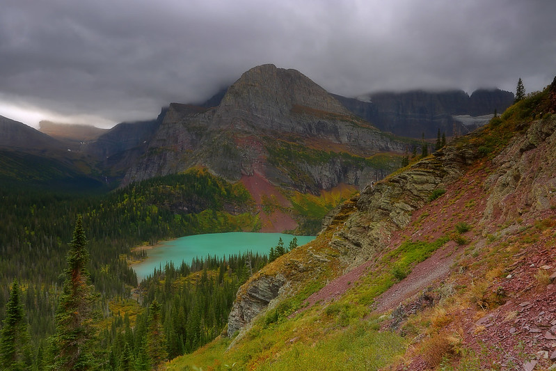
Hidden Lake and Bearhat Mountain


After retracing my steps to check out the tarns close to the pass, but which I'd blown past on my way up, I headed down to the lake on long gently graded switchbacks...until they weren't. The final part was steeper a tiny bit more rugged.


Bearhat Mountain, reflected in tarn


Hidden Lake and Clements Mountain

After getting my fill of the lake from its shores, I headed back up to the pass and onwards to the tarns on the other side. Here I took a right to head up the unofficial Reynolds Route to a pass between Reynolds Mountain and the Continental Divide. The pass was super windy, but provided a bird's eye view of Hidden Lake that was spectacular. I think this was the first time I was able to see the lake in its entirety. I also got a good look at the little islands I'd explored earlier, when down at the lake shores.

Reynolds Route meadows (selfie)

Logan Pass

Unhidden Hidden Lake
Not a drone shot


Sep 12: Iceberg Lake
10.6mi, 1500ft gain, 9hrs (including 4hrs at the lake)
After two days in the Logan Pass area, I was now going to spend the next three at the Many Glaciers region. I started with Cracker Lake, but only a few yards up the trail I came upon a sign for a trail closure due to bear activity. Drat.
One of the hikes on my list was the Ptarmigan Tunnel, which shared its first half with the first part of the trail to Iceberg Lake. The latter had not originally been on my must-do list, but in the tier just below. Now, with Cracker Lake out of the picture, I decided to skip Ptarmigan Tunnel and go with Iceberg Lake. (In hindsight I could and should have done both, but I was trying to pace myself at that stage.)
Due to my earlier snafu with Cracker Lake, it was a tardy (for me) 7:30am by the time I began my hike. It was cloudy start, with the occasional raindrop. The hike began by weaving in and out of bands of trees. Initial views across the valley of Grinnell Point and Mount Grinnell in particular were great. Later on, the Ptarmigan Wall could be seen off in the distance, standing like a picket fence across the horizon.


Mount Grinnell

Ptarmigan Wall (selfie)
Ptarmigan Falls, 2.5mi into the hike, made for a pleasant interlude. It's a pretty impressive waterfall, albeit hard to photograph due to its location. Shortly after that I walked past the trail to Ptarmigan Tunnel.


The final 1.5mi to the lake was through stunningly beautiful meadows, right below the Ptarmigan Wall. It was heavenly walking this stretch all the way to the cirque that held Iceberg Lake. I don't know why I'd initially picked Cracker Lake over this one, but that was probably an unwise choice. How much more impressive can a lake be? The backdrop of the Garden Wall and its jagged spires, rising more than 1500ft straight up, was jaw-dropping.

Heavenly meadows (selfie)


GaliWalker at Iceberg Lake (selfie)


Lower Iceberg Lake


Sep 13: Grinnell Glacier and a smashed camera
11.5mi, 2100ft gain, 7.5rs (including 3hrs at Upper Grinnell Lake)
I began the day with doing some morning photography at Swiftcurrent Lake: I'd wanted to get a nice sunrise shot of Grinnell Point from the shores of the lake. Unfortunately, an approaching storm had leached out all the color from the sky, so I didn't quite get what I wanted. Oh well, I still had a couple more cracks at it the next two days, or so I thought.


I was able to snag one of the final few spots at the Grinnell Glacier parking lot. By 7:30am, I was on my way, hiking under a light drizzle. As I crossed Swiftcurrent Creek on a footbridge, just 0.2mi in, I was treated to the most amazing morning light on Wynn Mountain. It was some quirk of the rain and the morning sun, and I was thankful to have witnessed it.

I hiked alongside the shores of Swiftcurrent Lake, and then Lake Josephine, amidst a steady stream of other hikers. At the far end of Lake Josephine the grade steepened and people began to spread out more. Eventually, I broke out into the open to a smashing view of turquoise colored Grinnell Lake in the valley below. The remaining hike to Upper Grinnell Glacier hugged a cliff face above Grinnell Lake. Gorgeous alpine meadows, bedecked with the beginnings of fall finery, and gleaming in the misty rain, periodically imparted their magic.


Lake Josephine inlet


Eventually, I was at the upper lake, and its namesake glacier. The little pools and lakelets dotting the outlet side of Upper Grinnell Lake drew me like a magnet. I took my time taking pictures, patiently waiting for others to clear out of my camera's field of view. I was in no hurry.


Next, I crossed the outlet stream and headed over to check out the Grinnell Glacier. At one point as I turned around to get something from my backpack, which I'd laid on the ground beside me, I noticed my camera taking a swan dive into a rocky pool. I tried to grab a tripod leg as the contraption toppled over but missed. I fished the camera out of the water; the lens had snapped in two and the camera was totally soaked. I quickly pulled out the memory card from the camera, packed away the various pieces of junk, and shut my brain off. I still had two more days in the park, but it would have to be iPhone camera time from now on.

Only iPhone pics from now on...


NOW the sun comes out!

Grinnell Lake


Lake Josephine
Sep 14: Swiftcurrent Mountain
17mi, 4200ft gain, 9.25hrs
One of the longer hikes on my list was the one of Swiftcurrent Pass. I'd originally though of taking a partial rest day, at this point in the trip, and prior to the Swiftcurrent Pass hike. I wanted to go look for moose, and I'd brought my 400mm lens along for just this purpose. However, without a proper camera at my disposal, and without having to lug the heavy camera gear around, I felt – dare I say it? – liberated. So, no rest days for me, partial or otherwise!
Back again at Swiftcurrent Lake, I began the day with taking an iPhone shot of Grinnell Point at sunrise. The light was great that morning, as if a vengeful god was laughing at my handicap, and I was going to make use of it!

After the quick interlude at Swiftcurrent Lake, I drove up the mile or so to the Swiftcurrent Pass trailhead. I was on the trail around 7:45am. I walked the mostly flat trail past Fishercap Lake, Redrock Lake (and falls), and finally Bullhead Lake. Grinnell Point loomed high on my left and Mount Wilbur kept it company on my right. This area is supposed to be prime moose habitat, but while I once heard a crashing sound in the woods which sounded suspiciously like a moose, I spotted none. (Note: There is an unnamed lake before Bullhead Lake which is not visible from the trail. It was only later, when looking down upon the lakes from up high that I realized that. The unfortunate thing was that I saw 4-6 moose there, but they were just dots on the lake at that distance.)

Fishercap Lake and Mount Wilbur

Fishercap Lake and Grinnell Point

Aspens, not quite with fall foliage

Mount Grinnell

Redrock Lake with Swiftcurrent Mountain at right

Redrock Falls

Bullhead Lake
After Bullhead Lake, the trail proceeded up-valley for a stretch, but a little before hitting the impassable headwall, it hung a right. A steady uphill ensued, first through the trees, and then through beautiful meadows and grasses. At this time, I broke out of Mount Grinnell's shadow and into the sun. All was right with the world.

Mount Wilbur


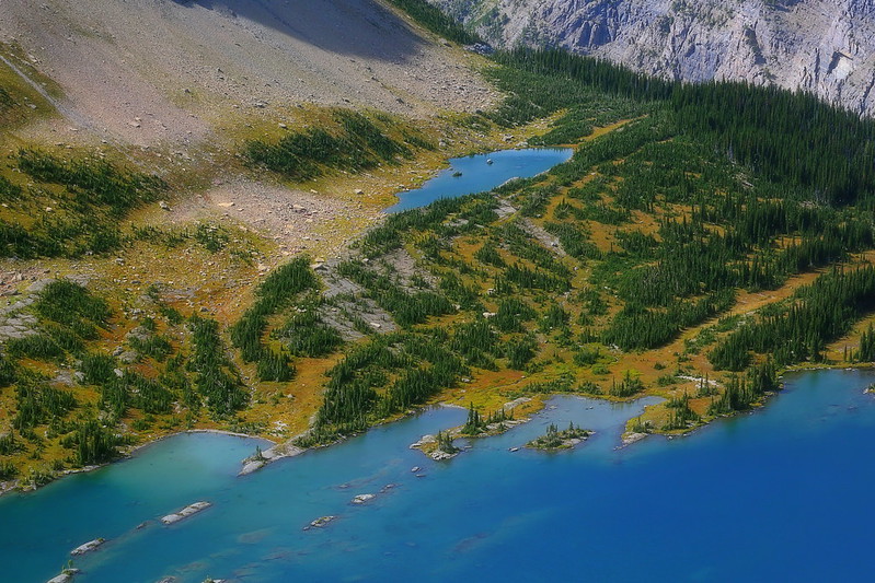
As I rose higher and higher all the lakes in the valley that I'd hiked past began to reveal themselves. Eventually, even the lakes I'd driven past started to show up. This view was why Swiftcurrent Pass had been in the top-most tier of my hiking list.

The two dots in the second lake from the bottom are moose

On my very first hike in the park, the Highline Trail, I'd noticed a fire lookout from the Granite Park Chalet, high up in the sky. It had looked extremely inviting. On this hike, I saw it once again from Redrock Lake, shining like a beacon in the morning sunshine. I'd decided then that I would not be satisfied with just the pass but would instead climb up Swiftcurrent Mountain to the Swiftcurrent Fire Lookout.
So, after gaining the pass, I hung a right onto the side trail to 8,436ft Swiftcurrent Mountain. Evidently, this is the highest maintained trail in the park. The 1.3mi to the summit gains 1250ft. The fire lookout was visible almost throughout, but for all the steady progress I was making, seemed to be coming no closer. It took me a never-ending 40min to get up top...which doesn't seem too long in retrospect, but sure did at the time. The view from the top was amazing. Nothing else I'd seen in the park was even close. This hike was, hands down, my favorite of all of the ones I'd do in Glacier National Park.

Tarn below Swiftcurrent Pass

Looking back at Mount Grinnell and Grinnell Point from just below Swiftcurrent Pass

Granite Park Chalet at center-left

Final stretch up Swiftcurrent Mountain

Heavens Peak across the valley

Swiftcurrent Pass at bottom-right

Mount Wilbur and nine lakes

Sea of peaks


Redrock Lake and Mount Wilbur
Sep 15: Siyeh Pass and the Sexton Glacier
11.2mi, 2460ft gain/3625ft drop, 6hrs
At 6:40am, when I began my hike to Siyeh Pass from the Siyeh Bend trailhead, I was the first person on the trail. I motored along the trail, making good time. 3mi in, I broke out of the trees into a frosty Preston Park, deep in the shadow of Matahpi Peak.

Piegan Mountain

Mount Siyeh
All by myself, I walked through the park to its far end, before beginning the climb up to Siyeh Pass, a saddle between Siyeh Peak to my left and Matahpi Peak to my right. As I reached the desolate pass, sunshine spilled all over me, as did the views. Right behind me was Preston Park, while the Boulder Creek Valley undulated downwards in front of me, all the way to the Montana prairie.

Piegan Mountain from Preston Park

Heavy Runner Mountain (left) and Piegan Mountain (right)

Approaching Siyeh Pass

Siyeh Pass (with tiny hikers at bottom-left)

Boulder Creek Valley
I continued to climb up the flanks of Matahpi Peak to a high point of 8100ft before I turned a corner and stood at the head of the Baring Creek Valley and my exit route. Just beyond Matahpi Peak stood Going-to-the-Sun Mountain, with the Sexton Glacier nestling comfortably at the base of the wall connecting the two peaks. While I could see that the trail did not go near the glacier, a route across scree and talus slopes beckoned to me. After heading a ways down the trail, I left it for the scree slopes, and then traversed over to the glacier. Yet more alone time, although an old boot print in the dirt near a glacial pool was proof that I was not the only one lured by the glacier.

8100ft

Matahpi Peak screes

Going-to-the-Sun Mountain and the Sexton Glacier


Once back on the main trail, I headed down the Baring Creek Valley. The barren upper reaches were soon taken over by lush grasses and silver snags from old fires. The open descent was via a series of long switchbacks, but the final part, Sunrift Gorge, was a more intimate affair. From a distance, it looked like a spectacular slot canyon; if I'd had more time, I might have spent some of it checking it out more closely. Like my very first day in the park, I caught the Going-to-the-Sun Road shuttle back to my car.


This trip was a long time coming. It would be my first trip to any of the big three National Parks in Montana/Wyoming: Yellowstone, Grand Teton, and Glacier National Park. The last one is now in the books.
I flew in to Kalispell on Saturday, Sep 9, picked up my rental car, and checked in to my motel on the east side of the park, which was the side I'd picked all my hikes on.
Sep 10: Highline Trail
11.8mi, 1100ft gain/2400ft+ drop, 6.5hrs
Sep 10 was the final day when the high-visitation vehicle reservation system was in effect; this limited the number of cars allowed on the Going-to-the-Sun Road and at various other sites in the park. It was also the last day that the Going-to-the-Sun Road shuttle ran on a full schedule. Since I planned to use the shuttle to get back to my car for the one-way Highline Trail hike, I decided to pick it as my first hike to do in the park. Later on, I would use the shuttle once more, but by then I was more familiar with the system and less concerned about these logistics.
The hike began from the super popular Logan Pass parking lot. When I arrived there at 5:55am, it seemed that the parking lot was about a third full, but a steady stream of cars was rapidly filling it up. I waited in the car for around 40min before setting out, because the views would start immediately, and I wanted to start taking pictures as soon as it got bright enough to do so.
The hike began by cozying up to a ledge under the cliffs of the Garden Wall. They had a handline strung up for folks who had issues with the steep drop-off down to the Going-to-the-Sun Road a few hundred feet below, but the trail was mostly level and quite wide. The 'infamous' nature of that ledge was underwhelming for me. The views, however, were anything but underwhelming!
I took my time meandering along the trail, in the shadow of the Garden Wall. 2.5mi in I reached Haystack Pass, below the impressive Haystack Butte. As I paused to take a selfie, the sun broke over the pass from behind and sunshine splashed all over me, for the first time that day. I felt great!
Haystack Pass (selfie)
Haystack Butte
Highline Trail (selfie)
Heavens Peak, with Lake McDonald in the distance
At 7.6mi I reached Granite Park Chalet, where I had a snack, before embarking on the seemingly never-ending 4mi and 2400ft descent down to the 'Loop' on the Going-to-the-Sun Road. I had no problem catching the shuttle back to my car at Logan Pass.
On my drive back to my motel I stopped at Sun Point for a more distant view of the park, since I'd missed that on my drive in, in the wee hours of the morning.
Sep 11: Hidden Lake environs
9mi, 1700ft gain, 9.25hrs
The trail for Hidden Lake also began from Logan Pass, with which I was now familiar from the previous day. I wanted to be at Hidden Lake Pass and the overlook, 1.4mi from the trailhead, well before sunrise and ready for the best light. So, I was in a nearly empty parking lot by 5:45am, and hiking by 6am. I made good time up the gentle climb – a combination of pavement, boardwalk and manicured dirt – and was at the overlook in 30min. Dawn was pretty spectacular.
Hidden Lake and Bearhat Mountain
After retracing my steps to check out the tarns close to the pass, but which I'd blown past on my way up, I headed down to the lake on long gently graded switchbacks...until they weren't. The final part was steeper a tiny bit more rugged.
Bearhat Mountain, reflected in tarn
Hidden Lake and Clements Mountain
After getting my fill of the lake from its shores, I headed back up to the pass and onwards to the tarns on the other side. Here I took a right to head up the unofficial Reynolds Route to a pass between Reynolds Mountain and the Continental Divide. The pass was super windy, but provided a bird's eye view of Hidden Lake that was spectacular. I think this was the first time I was able to see the lake in its entirety. I also got a good look at the little islands I'd explored earlier, when down at the lake shores.
Reynolds Route meadows (selfie)
Logan Pass
Unhidden Hidden Lake
Not a drone shot
Sep 12: Iceberg Lake
10.6mi, 1500ft gain, 9hrs (including 4hrs at the lake)
After two days in the Logan Pass area, I was now going to spend the next three at the Many Glaciers region. I started with Cracker Lake, but only a few yards up the trail I came upon a sign for a trail closure due to bear activity. Drat.
One of the hikes on my list was the Ptarmigan Tunnel, which shared its first half with the first part of the trail to Iceberg Lake. The latter had not originally been on my must-do list, but in the tier just below. Now, with Cracker Lake out of the picture, I decided to skip Ptarmigan Tunnel and go with Iceberg Lake. (In hindsight I could and should have done both, but I was trying to pace myself at that stage.)
Due to my earlier snafu with Cracker Lake, it was a tardy (for me) 7:30am by the time I began my hike. It was cloudy start, with the occasional raindrop. The hike began by weaving in and out of bands of trees. Initial views across the valley of Grinnell Point and Mount Grinnell in particular were great. Later on, the Ptarmigan Wall could be seen off in the distance, standing like a picket fence across the horizon.
Mount Grinnell
Ptarmigan Wall (selfie)
Ptarmigan Falls, 2.5mi into the hike, made for a pleasant interlude. It's a pretty impressive waterfall, albeit hard to photograph due to its location. Shortly after that I walked past the trail to Ptarmigan Tunnel.
The final 1.5mi to the lake was through stunningly beautiful meadows, right below the Ptarmigan Wall. It was heavenly walking this stretch all the way to the cirque that held Iceberg Lake. I don't know why I'd initially picked Cracker Lake over this one, but that was probably an unwise choice. How much more impressive can a lake be? The backdrop of the Garden Wall and its jagged spires, rising more than 1500ft straight up, was jaw-dropping.
Heavenly meadows (selfie)
GaliWalker at Iceberg Lake (selfie)
Lower Iceberg Lake
Sep 13: Grinnell Glacier and a smashed camera
11.5mi, 2100ft gain, 7.5rs (including 3hrs at Upper Grinnell Lake)
I began the day with doing some morning photography at Swiftcurrent Lake: I'd wanted to get a nice sunrise shot of Grinnell Point from the shores of the lake. Unfortunately, an approaching storm had leached out all the color from the sky, so I didn't quite get what I wanted. Oh well, I still had a couple more cracks at it the next two days, or so I thought.
I was able to snag one of the final few spots at the Grinnell Glacier parking lot. By 7:30am, I was on my way, hiking under a light drizzle. As I crossed Swiftcurrent Creek on a footbridge, just 0.2mi in, I was treated to the most amazing morning light on Wynn Mountain. It was some quirk of the rain and the morning sun, and I was thankful to have witnessed it.
I hiked alongside the shores of Swiftcurrent Lake, and then Lake Josephine, amidst a steady stream of other hikers. At the far end of Lake Josephine the grade steepened and people began to spread out more. Eventually, I broke out into the open to a smashing view of turquoise colored Grinnell Lake in the valley below. The remaining hike to Upper Grinnell Glacier hugged a cliff face above Grinnell Lake. Gorgeous alpine meadows, bedecked with the beginnings of fall finery, and gleaming in the misty rain, periodically imparted their magic.
Lake Josephine inlet
Eventually, I was at the upper lake, and its namesake glacier. The little pools and lakelets dotting the outlet side of Upper Grinnell Lake drew me like a magnet. I took my time taking pictures, patiently waiting for others to clear out of my camera's field of view. I was in no hurry.
Next, I crossed the outlet stream and headed over to check out the Grinnell Glacier. At one point as I turned around to get something from my backpack, which I'd laid on the ground beside me, I noticed my camera taking a swan dive into a rocky pool. I tried to grab a tripod leg as the contraption toppled over but missed. I fished the camera out of the water; the lens had snapped in two and the camera was totally soaked. I quickly pulled out the memory card from the camera, packed away the various pieces of junk, and shut my brain off. I still had two more days in the park, but it would have to be iPhone camera time from now on.
Only iPhone pics from now on...
NOW the sun comes out!
Grinnell Lake
Lake Josephine
Sep 14: Swiftcurrent Mountain
17mi, 4200ft gain, 9.25hrs
One of the longer hikes on my list was the one of Swiftcurrent Pass. I'd originally though of taking a partial rest day, at this point in the trip, and prior to the Swiftcurrent Pass hike. I wanted to go look for moose, and I'd brought my 400mm lens along for just this purpose. However, without a proper camera at my disposal, and without having to lug the heavy camera gear around, I felt – dare I say it? – liberated. So, no rest days for me, partial or otherwise!
Back again at Swiftcurrent Lake, I began the day with taking an iPhone shot of Grinnell Point at sunrise. The light was great that morning, as if a vengeful god was laughing at my handicap, and I was going to make use of it!
After the quick interlude at Swiftcurrent Lake, I drove up the mile or so to the Swiftcurrent Pass trailhead. I was on the trail around 7:45am. I walked the mostly flat trail past Fishercap Lake, Redrock Lake (and falls), and finally Bullhead Lake. Grinnell Point loomed high on my left and Mount Wilbur kept it company on my right. This area is supposed to be prime moose habitat, but while I once heard a crashing sound in the woods which sounded suspiciously like a moose, I spotted none. (Note: There is an unnamed lake before Bullhead Lake which is not visible from the trail. It was only later, when looking down upon the lakes from up high that I realized that. The unfortunate thing was that I saw 4-6 moose there, but they were just dots on the lake at that distance.)
Fishercap Lake and Mount Wilbur
Fishercap Lake and Grinnell Point
Aspens, not quite with fall foliage
Mount Grinnell
Redrock Lake with Swiftcurrent Mountain at right
Redrock Falls
Bullhead Lake
After Bullhead Lake, the trail proceeded up-valley for a stretch, but a little before hitting the impassable headwall, it hung a right. A steady uphill ensued, first through the trees, and then through beautiful meadows and grasses. At this time, I broke out of Mount Grinnell's shadow and into the sun. All was right with the world.
Mount Wilbur
As I rose higher and higher all the lakes in the valley that I'd hiked past began to reveal themselves. Eventually, even the lakes I'd driven past started to show up. This view was why Swiftcurrent Pass had been in the top-most tier of my hiking list.
The two dots in the second lake from the bottom are moose
On my very first hike in the park, the Highline Trail, I'd noticed a fire lookout from the Granite Park Chalet, high up in the sky. It had looked extremely inviting. On this hike, I saw it once again from Redrock Lake, shining like a beacon in the morning sunshine. I'd decided then that I would not be satisfied with just the pass but would instead climb up Swiftcurrent Mountain to the Swiftcurrent Fire Lookout.
So, after gaining the pass, I hung a right onto the side trail to 8,436ft Swiftcurrent Mountain. Evidently, this is the highest maintained trail in the park. The 1.3mi to the summit gains 1250ft. The fire lookout was visible almost throughout, but for all the steady progress I was making, seemed to be coming no closer. It took me a never-ending 40min to get up top...which doesn't seem too long in retrospect, but sure did at the time. The view from the top was amazing. Nothing else I'd seen in the park was even close. This hike was, hands down, my favorite of all of the ones I'd do in Glacier National Park.
Tarn below Swiftcurrent Pass
Looking back at Mount Grinnell and Grinnell Point from just below Swiftcurrent Pass
Granite Park Chalet at center-left
Final stretch up Swiftcurrent Mountain
Heavens Peak across the valley
Swiftcurrent Pass at bottom-right
Mount Wilbur and nine lakes
Sea of peaks
Redrock Lake and Mount Wilbur
Sep 15: Siyeh Pass and the Sexton Glacier
11.2mi, 2460ft gain/3625ft drop, 6hrs
At 6:40am, when I began my hike to Siyeh Pass from the Siyeh Bend trailhead, I was the first person on the trail. I motored along the trail, making good time. 3mi in, I broke out of the trees into a frosty Preston Park, deep in the shadow of Matahpi Peak.
Piegan Mountain
Mount Siyeh
All by myself, I walked through the park to its far end, before beginning the climb up to Siyeh Pass, a saddle between Siyeh Peak to my left and Matahpi Peak to my right. As I reached the desolate pass, sunshine spilled all over me, as did the views. Right behind me was Preston Park, while the Boulder Creek Valley undulated downwards in front of me, all the way to the Montana prairie.
Piegan Mountain from Preston Park
Heavy Runner Mountain (left) and Piegan Mountain (right)
Approaching Siyeh Pass
Siyeh Pass (with tiny hikers at bottom-left)
Boulder Creek Valley
I continued to climb up the flanks of Matahpi Peak to a high point of 8100ft before I turned a corner and stood at the head of the Baring Creek Valley and my exit route. Just beyond Matahpi Peak stood Going-to-the-Sun Mountain, with the Sexton Glacier nestling comfortably at the base of the wall connecting the two peaks. While I could see that the trail did not go near the glacier, a route across scree and talus slopes beckoned to me. After heading a ways down the trail, I left it for the scree slopes, and then traversed over to the glacier. Yet more alone time, although an old boot print in the dirt near a glacial pool was proof that I was not the only one lured by the glacier.
8100ft
Matahpi Peak screes
Going-to-the-Sun Mountain and the Sexton Glacier
Once back on the main trail, I headed down the Baring Creek Valley. The barren upper reaches were soon taken over by lush grasses and silver snags from old fires. The open descent was via a series of long switchbacks, but the final part, Sunrift Gorge, was a more intimate affair. From a distance, it looked like a spectacular slot canyon; if I'd had more time, I might have spent some of it checking it out more closely. Like my very first day in the park, I caught the Going-to-the-Sun Road shuttle back to my car.


