

Post by Coolkat on Sept 13, 2023 17:04:17 GMT -8
As a side note, we had the best weather one could ask for on this trip. Zero rain and nights in the high 40s and days at the most in the low 70s. If there had been rain or hot weather, it might have made this hike almost unbearable. It turned into a bit of a beat down that we were not expecting as it was. This hike was also my first hike that was 98% all compass and/or gps work. There are no maintained trails here. Oh.. the McCormick Wilderness is a smaller tract of land in the UP of Michigan in the Ottawa National Forest.
Edit: For the sake keeping sanity we won't discuss the mosquitoes

Day 1
On trail and hiking by 8:30 if I remember correctly. As we enter the McCormick, Jay and his wife stop to enter our names into the register, and we continue down to the West Branch Yellow Dog Falls.

At this point the trail is obvious and easy to follow. When we get to the falls, we drop our packs and kill about 30 minutes going up and down the falls look for the best place for pictures.

Then back on the trail heading slightly SE until we turn a hard right and are now facing SW with a trail that is more or less gone by now, but we are still following foot prints and broken branches of the people who've gone before us. These falls are somewhat popular, but the 2nd falls are much harder to get to which is why the trail disappears.
Now we are at Yellow Dog Falls and navigating has become much harder and the trail has disappeared at this point.
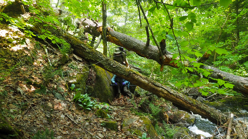

A significant number of new blow downs are hindering our progress not to mention the all the old dead-fall. Its beginning to feel like 3 steps forward and 2 steps back. But forward we go with the dam at Bulldog Lake as our goal. A couple of more water crossings and we made it to the dam.


But much to our dismay there is no place to camp here and we've more or less spent all our energy. I subscribe to a different map app than he does so I pull out my phone and take a look. And as I look there is supposedly a beach about 1/4 mile beyond the dam. Jay tells his wife to stay put and we put a new bearing in our compasses and head off. In about 12 minutes later we do indeed find the beach but its not really what I had in mind but at least its campable (sp? is that word?) and has easily accessible water. Once camp is setup Jay pulls out his gps and to discover that while we've barely done 5 miles the gps reads closer to 9 which confirms our feelings about the progress for the day. We are beat and ready for bed. After camp is setup Jay tries his hand at some kind of bread where you just throw the dough directly onto hot coals and it turns out better than I thought.


Day 2
On the morning of the 2nd day everyone is still feeling beat so we don't get camp torn down and ready to start hiking until about 10am. While navigating itself hasn't been much of an issue the effort needed to make from point A to point B has Jay and I discussing the need to significantly alter the trip itinerary. However, we decide to wait until the morning of day 3 to change things to see how everyone is doing. So off we start...

Today's goal is the foundation of the lodge that housed people on their vacations at the turn of the century. This is just a little beyond 2 miles and believe that this is very doable even though we didn't get started until 10am. However, forward progress this day even put makes us wonder if we can actually get the 2 miles in. This is what we faced and worse for the remainder of the day.

Finally about just a few minutes before 5pm we make to our goal. The old lodge foundation at the south end of White Dear Lake.


With sunset not until after 9:30 this gives us plenty of time to make camp, get a little rest in and then finally eat supper and Jay tries his hand again at making another batch of bread directly on the coals. While last night's batch was good Jay has significantly improved his skill tonight. With a little honey this warm bread really really hits the spot.

After dinner was over I try my hand at making some Chaga tea that we harvested from a Birch tree earlier in the day. I have to admit that it was different it is also very good.

Then I play around with my camera to see if I can get some really small flowers into focus.

Day 3
Day 3 was ummm... day 3. Jay and I talked about how to alter our trip plans because its become obvious we are not going to be able to accomplish the original itinerary. We decide to go see the "Old Fortress" a high bluff on the other side of the lake and then try to locate an old logging road and follow that. We did find bits and pieces of it but mother nature had completely taken over and more or less left little indication of its where abouts.
Just to give you an idea of what it was like we were hiking by about 9am and finished about 7pm and how far did we go? 2 miles... 2 WHOLE miles!! Thats all I'll say about that. One of the significant obstacles that was overcome today was a 350ft wide Alder infested marsh with a stream in the middle. This probably ate up about an hour and once it was crossed it dumped us into even worse blow-down entangled forest.


Day 4
Today was welcome relief. We were able to hike among large tall deciduous trees with little undergrowth which made it very easy to get the last 5 miles of the trip done by early afternoon which left me plenty of time to make the 8.5 drive home by midnight. If the other days had been as easy as this one we could have easily been able to see more of this wonderful wilderness like we wanted to from the beginning.


If for some reason you wish to see all the pics you can find those here...
flic.kr/s/aHBqjAUzEK
Edit: For the sake keeping sanity we won't discuss the mosquitoes
Day 1
On trail and hiking by 8:30 if I remember correctly. As we enter the McCormick, Jay and his wife stop to enter our names into the register, and we continue down to the West Branch Yellow Dog Falls.
At this point the trail is obvious and easy to follow. When we get to the falls, we drop our packs and kill about 30 minutes going up and down the falls look for the best place for pictures.
Then back on the trail heading slightly SE until we turn a hard right and are now facing SW with a trail that is more or less gone by now, but we are still following foot prints and broken branches of the people who've gone before us. These falls are somewhat popular, but the 2nd falls are much harder to get to which is why the trail disappears.
Now we are at Yellow Dog Falls and navigating has become much harder and the trail has disappeared at this point.
A significant number of new blow downs are hindering our progress not to mention the all the old dead-fall. Its beginning to feel like 3 steps forward and 2 steps back. But forward we go with the dam at Bulldog Lake as our goal. A couple of more water crossings and we made it to the dam.
But much to our dismay there is no place to camp here and we've more or less spent all our energy. I subscribe to a different map app than he does so I pull out my phone and take a look. And as I look there is supposedly a beach about 1/4 mile beyond the dam. Jay tells his wife to stay put and we put a new bearing in our compasses and head off. In about 12 minutes later we do indeed find the beach but its not really what I had in mind but at least its campable (sp? is that word?) and has easily accessible water. Once camp is setup Jay pulls out his gps and to discover that while we've barely done 5 miles the gps reads closer to 9 which confirms our feelings about the progress for the day. We are beat and ready for bed. After camp is setup Jay tries his hand at some kind of bread where you just throw the dough directly onto hot coals and it turns out better than I thought.
Day 2
On the morning of the 2nd day everyone is still feeling beat so we don't get camp torn down and ready to start hiking until about 10am. While navigating itself hasn't been much of an issue the effort needed to make from point A to point B has Jay and I discussing the need to significantly alter the trip itinerary. However, we decide to wait until the morning of day 3 to change things to see how everyone is doing. So off we start...
Today's goal is the foundation of the lodge that housed people on their vacations at the turn of the century. This is just a little beyond 2 miles and believe that this is very doable even though we didn't get started until 10am. However, forward progress this day even put makes us wonder if we can actually get the 2 miles in. This is what we faced and worse for the remainder of the day.
Finally about just a few minutes before 5pm we make to our goal. The old lodge foundation at the south end of White Dear Lake.
With sunset not until after 9:30 this gives us plenty of time to make camp, get a little rest in and then finally eat supper and Jay tries his hand again at making another batch of bread directly on the coals. While last night's batch was good Jay has significantly improved his skill tonight. With a little honey this warm bread really really hits the spot.
After dinner was over I try my hand at making some Chaga tea that we harvested from a Birch tree earlier in the day. I have to admit that it was different it is also very good.
Then I play around with my camera to see if I can get some really small flowers into focus.
Day 3
Day 3 was ummm... day 3. Jay and I talked about how to alter our trip plans because its become obvious we are not going to be able to accomplish the original itinerary. We decide to go see the "Old Fortress" a high bluff on the other side of the lake and then try to locate an old logging road and follow that. We did find bits and pieces of it but mother nature had completely taken over and more or less left little indication of its where abouts.
Just to give you an idea of what it was like we were hiking by about 9am and finished about 7pm and how far did we go? 2 miles... 2 WHOLE miles!! Thats all I'll say about that. One of the significant obstacles that was overcome today was a 350ft wide Alder infested marsh with a stream in the middle. This probably ate up about an hour and once it was crossed it dumped us into even worse blow-down entangled forest.
Day 4
Today was welcome relief. We were able to hike among large tall deciduous trees with little undergrowth which made it very easy to get the last 5 miles of the trip done by early afternoon which left me plenty of time to make the 8.5 drive home by midnight. If the other days had been as easy as this one we could have easily been able to see more of this wonderful wilderness like we wanted to from the beginning.
If for some reason you wish to see all the pics you can find those here...
flic.kr/s/aHBqjAUzEK


