|
|
Post by Coolkat on Aug 20, 2015 9:41:01 GMT -8
Has anyone hiked the Fox River Pathway recently? I did it many years back and it was poorly marked. Getting ready to hike it again and am wondering if they have redone the blazes?
|
|
|
|
Post by Coolkat on Sept 23, 2015 5:03:46 GMT -8
Just got done doing the Fox River Pathway a couple of weeks ago. It was a ton fun just don't do it yourself unless you're good with map and compass or have gps way points for the trail. It's still very well UNmarked. Old blazes are either almost entirely faded or on dead trees that have fallen underneath the ferns or hidden by brush.Here are some pics for those interested. Just click on the appropriately named album. Fox River Pathway |
|
Deleted
Deleted Member
Posts: 0
|
Post by Deleted on Oct 6, 2015 0:59:27 GMT -8
Great Pictures. How were the bugs this year.
Last September on the Superior Trail the mosquitoes were nothing compared to the flies.
Hope to be headed that way next week.
|
|
|
|
Post by Coolkat on Oct 6, 2015 5:58:35 GMT -8
Bugs were almost non-existent. Which is why I almost always wait until after mid August for my hiking trips in the upper peninsula. I'm kinda surprised to hear that you had bugs that time of year that far north.
Headed which way? Superior Hiking Trail? I've thought about but never had made the trip to there. I've heard though you don't see much of the actual lake from the trail.
|
|
RedDoug
Trail Wise!
Trail active, stand back.....
Posts: 634 
|
Post by RedDoug on Dec 1, 2015 23:34:32 GMT -8
At one time I knew the Fox River Pathway as well as anyone- I am sure of it. The 2nd half above Stanley Lake is getting overgrown. Coolkat had me with him this fall and I think I am pretty good with map and compass in that area, but even I lost the trail in a few sections.
|
|
Hungry Jack
Trail Wise!
Living and dying in 3/4 time...
Posts: 3,809
|
Post by Hungry Jack on Feb 10, 2016 11:26:26 GMT -8
Great pics! Sounds (and looks) like you had your hands full navigating that route. It's on my "to do: list but hopefully they can do some maintenance. Would be fun to combine it with the western-most 25 miles or so of the PixRox Shoreline Trail. I was at the trail junction just last August.
|
|
|
|
Post by Coolkat on Feb 10, 2016 12:59:26 GMT -8
Would be fun to combine it with the western-most 25 miles or so of the PixRox Shoreline Trail. I haven't done it with the western most half of the PicRocks trail but my very first backpack trip with RedDoug was the eastern half combined with the Fox River Pathway. But with the views of the western half I understand why you'd want to do that. That would be a very nice hike indeed. Trail maintenance is on the "list" for maintenance from The Nature Conservancy However, they told me it was kinda low on the priority list and they are aware of the condition of the trail. Apparently volunteers are far and few between up there. If they ever do end up getting blazed again I hope thats all they do is blaze trees. It's kinda cool/fun to not have a "trail" to follow. |
|
Hungry Jack
Trail Wise!
Living and dying in 3/4 time...
Posts: 3,809
|
Post by Hungry Jack on Feb 11, 2016 7:36:52 GMT -8
Have you not done the stretch from Coves to Miners?
|
|
|
|
Post by Coolkat on Feb 11, 2016 10:28:59 GMT -8
Have you not done the stretch from Coves to Miners? I always hike east to west and I normally get out at either Sand Point or Miners Castle. I like the last part of the trip to have those awesome views. Pic Rocks 2010 (solo) flic.kr/s/aHsknx6ng6Pic Rocks 2013 (with a newbie) flic.kr/s/aHsknwWnj1 |
|
Hungry Jack
Trail Wise!
Living and dying in 3/4 time...
Posts: 3,809
|
Post by Hungry Jack on Feb 11, 2016 11:21:09 GMT -8
Got it. I prefer the same itinerary. Mile for mile, PixRox has the best scenery between the Presi Traverse in NH and the Rockies, IMO.
Have you checked out Grand Island?
I love your albums. Great stuff. Nice Tarp Tent. I have a Squall 2, and it looks like might have one too, though the rear stake looks different. Great tent for warm weather.
|
|
|
|
Post by Coolkat on Aug 3, 2016 5:29:00 GMT -8
Not sure why I didn't respond to this earlier by my tarptent is a contrail. However, I'm thinking about getting a Double Rainbow or a Notch. Haven't decided yet. Hopefully I'll have it figured out by my october trip. |
|
|
|
Post by Coolkat on Sept 30, 2020 19:32:39 GMT -8
Well I just finished this trail again and it was great time and colors were fantastic. Fox River Pathway 2020Some conservancy group has attempted to reblaze the trail and make it easier to follow but it's still lacking and with water tables apparently being up plan on getting your feet wet. |
|
|
|
Post by Coolkat on Oct 8, 2020 8:47:47 GMT -8
With the water tables being up in Michigan it made things interesting. Near Folley lake where a small slow stream enters/exits the lake it was so high that someone earlier in the year cut some young poplar trees to put across it to form a make-shift bridge. If it hadn't been for that it would have probably been close to a waist deep wade.  Then going north out of the Stanley lake area the low marsh this time was high that you end up wading through a calf high water. I ended up nick naming this area the land of "feet never dry" because although it only rained at night the ferns and high grass held the water until late into the afternoon.  |
|
|
|
Post by Coolkat on Oct 12, 2022 7:59:39 GMT -8
It's on my "to do: list but hopefully they can do some maintenance. Well, if you ever put this back on your itinerary it's much easier to follow these days. The hardest part from the north side of the Kingston Plains to Kingston campgrounds has been helped with navigation posts. I've done this trail 3 years in a row now with no issues. In 2018 I lost the trail and had to bushwack to H-58. The colors were really good this year again. flic.kr/s/aHBqjAagjg |
|
|
|
Post by Coolkat on Nov 3, 2023 12:37:32 GMT -8
 Day 1 Day 1This year for my fall hike I did things a bit differently. I backpacked 2 different trails both very similar in length 37 miles and 35 miles. This is the second of the 2 hikes the trail that I do most years. This trail has a special place in my heart since this is where I did my very first backpacking trip in 2008. This year I got started on the trail about 11:30am 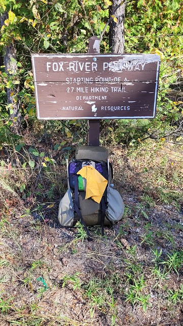 I've done this trail several times and I like to stop at some of the same places that I've taken pictures before to compare to other years. Like this spot.  Another couple of miles down the trail it turns on to some two-track that reveals the sandy soil that is so prevalent in this area. Even though this is two-track and not a "trail" I've come to enjoy this section as it usually has some tell tale signs of the local critters and this year I'm not disappointed. It appears that there is or was a small bear in the area.  At about 5 miles in the trail passes through a state forest campground where I stop and take my lunch break and get some water from the pump so I don't have to filter this evening. It appears this year that even though I'm here on the same weekend that I always do I'm probably about a week past peak color as this tree is normally full and bright red.  Another 5 miles and I get to my goal. A nice pine needle covered area next to the river. Water here is accessible but not necessarily easy to get. I get camp setup and settle in for the evening and just enjoy the solitude and plan the next 3 days schedule and where I want to camp as its suppose to be fairly rainy.  Day 2 Day 2In the morning I go through my normal ritual eating breakfast and breaking down camp and get going. Just a couple of miles into the day and looked down and find someone's SeaToSummit head net. If they hiked this trail before August I'm guessing they really missed it as the bugs are crazy here then. I already have a head net so I place it on an obvious branch nearby for someone else or maybe the original owners if they hike this trail again next year. I will say though that I'm somewhat surprised at finding this because I've never ever seen another soul hiking this trail. 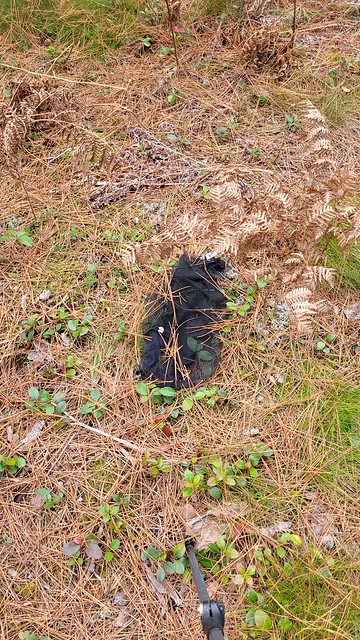  By early afternoon I've mad enough miles and that I decide to stop for the day and camp at my favorite spot on this trail. There is just something about this spot underneath some huge White Pines and tall Norwegian Red Pines right next to a lake that almost make this place cathedral like for me.  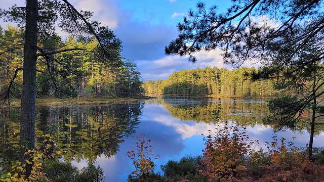 The rest of the day is spent literally napping on the pine needles and walking down to the old dam to get water for dinner and breakfast. Day 3This hike so far as been rain free very unlike the forecast I saw before I left that said was saying 75% and 80% chance of rain almost every day of the hike. I'm not complaining though! There has obviously been a frost here as a lot of the Braken ferns are dead. There is also the lack of dew which is a 2nd bonus since walking through these with even a light dew is like walking all day in a down pour.  Today I run into something I've never seen on this trail before... another human. I was hiking north and was going around a bend only meet a woman hiking south. We chatted a few and then went our separate ways. By early afternoon I find myself on the Kingston Plains. As far as you can see is nothing but stumps from White Pines that were logged off in the late 1800's (for the Chicago fire I think, but don't quote me on that). It has an odd vibe to go with it. Kinda like walking through a ghost forest. This would have been incredible to see before it had been logged off.   This time I hike until mid to late afternoon before stopping for the day. I get things setup and take a short nap. It's so nice not be on a hard schedule. 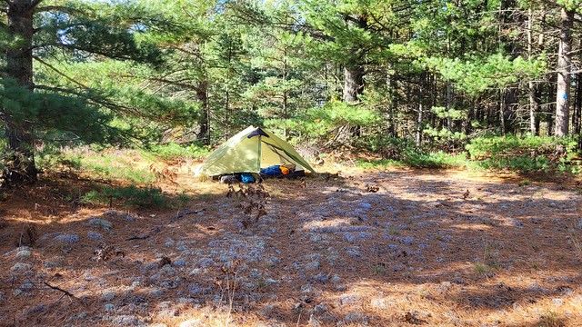  Early that morning the forecasted rains showed up in the form of a thunderstorm that rolled through and the winds picked up for a while but nothing scary Day 4Day 4 I find myself packing up a wet tent even after trying to "dry" it with a chamois but such the life of a backpacker. This is a shorter day with only about 7 miles to cover. All packed up and ready to go.   About 5 miles later I find myself at the end of the Fox River Pathway as it dumps me out onto the shore of Lake Superior. Now only two miles to my car and then 15 miles via car to the local eatery. Again and another fall hike behind me that didn't disappoint. 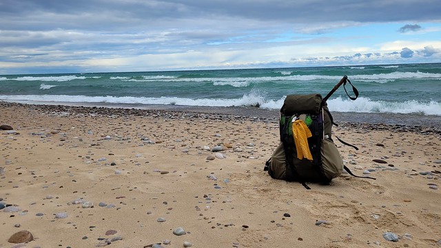 If you'd like to see all the pictures you can find them here flic.kr/s/aHBqjB229b |
|
 Image Credit / Coolkat


