driftwoody
Trail Wise!
Take the path closer to the edge, especially if less traveled
Posts: 14,961 
|
Post by driftwoody on Nov 24, 2018 12:16:36 GMT -8
ashepabst I've visited the Cap Rock Chimney twice and it is definitely something you should make time to go see. Nearby Russell Arch (also known as Morning Arch) is a quick hop and skip from Cap Rock Chimney and is a must-see if you are in the area. On my first visit, my friend and I left the very faint trail that leads out the ridge from the Maude's Crack Trail much too soon. We ended up making things very difficult on ourselves (deadfall, briars, etc.), but we eventually found the Cap Rock Chimney and wow . . . what a sight to behold! It is certainly one of the coolest formations I've seen in the Cumberland Plateau. From Cap Rock Chimney, we made the simple, short climb (steep, but not even really a scramble) back onto the ridge, hit the remnants of a trail/road and then were back at the Maude's Crack Trail in a 1/10 of the time it took us to reach the chimney. Pic:ures do not do it justice, and there is a window in the chimney that isn't visible in this picture, but here is one anyway: 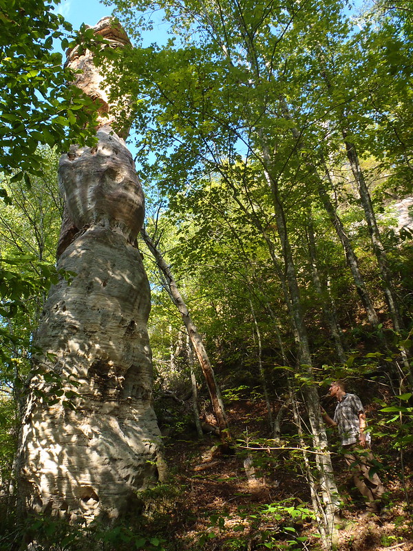 On our second visit, we simply followed the faint trail out the ridge to where we knew to scramble down to Cap Rock Chimney (and could just barely see it through the trees) and were there in maybe 10 minutes. We then made the brief stroll over to Morning/Russell Arch which was maybe a 5-minute hike away: 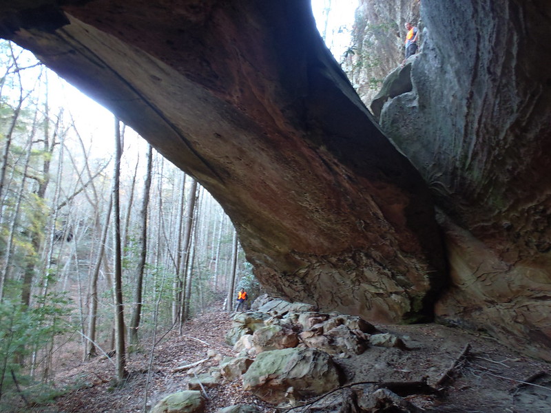 If you have the landforms plotted on a map (the coordinates are on TN Landforms, I think) and are decent at off-trail navigation then you shouldn't have any trouble finding these . . . maybe give yourself 90 minutes round-trip to visit both, which includes ample time for gawking. Only advice I can really give is DO NOT leave the ridge too soon when you are on your way to Cap Rock Chimney. There was an extremely faint trail when I was there in 2012, but not sure what it is like now. On Saturday Nov 3 I drove 531 miles to the trail head at Terry cemetery, then camped near Maude's overlook. On Sunday I tried to find Cap Rock and Russell Arch. I had the GPS coordinates from TN Landforms on my phone in my Gaia app, and a route off the trail to Maude's overlook was marked with pink ribbons. That marked route appeared to be in the right place and I didn't see any other good path through the forest understory thick with brush and thorn vines. The marked route was pretty thick as well and would have been nearly impossible to follow without the frequent ribbons. If I hadn't worn long pants my legs would have looked like cat scratch fever. I followed the marked route past where it should have branched off to the landforms I sought, then the ribbons came to an end. I tried continuing in four different directions but they all became nearly impassable, so I reversed course. On the way back I spotted a spur marked with ribbons I has missed before, which (based on my GPS) led to Cap Rock. This path became even rougher than the main route, bit it did lead to the a view of the top of Cap Rock:  The marked route ended where I snapped the above pic. The descent ahead was so thick with brush & thorns that I didn't even try reaching the base. However, I still wanted to find Russell Arch. Following the marked route back towards Maude's trail I kept a sharp eye for any path leading to the left towards the Russell Arch coordinates on my GPS. I found none, but explored as far as I could along the base of the bluff which should have the arch. Couldn't get very far at all and saw no signs of a human footpath, so I finally gave up. Went back to my car at Terry Cemetery TH to get my full pack for the overnight venture to No Business Creek. I headed down the Longfield Branch Trail, crossed NB Creek, headed west on NB Creek trail, then crossed NB Creek again to head up Anderson Cave Branch to seek the waterfall at its head. The water in AC Branch was seldom higher than my waterproof Ahnu Coburn boots, so I made my way staying dry upstream through the creek and out of it wherever a flat bench of land paralleled it. The going was considerably easier than my misadventure earlier in the day. I was feeling pretty good about my progress, then I came to the point pictured below where a deep pool split a steep rise on either side:  It was pretty chilly that day and I did not feel like getting wet, so I tried to go up and around. The left side looked less precarious so up I went past a difficult sloped spot with nothing to hold onto (trekking poles were just enough to keep me from sliding down) but beyond the apex looked too damn risky to attempt. Hiking alone off trail in a remote area at age 61, prudence ended this quest as well. Overall not a proud day for this veteran hiker, but still adventurous with some good exercise. And the day was far from a complete bust, because I still had a backcountry night ahead of me and that morning I had some glorious early morning fall color views from Maude's Overlook:    |
|
driftwoody
Trail Wise!
Take the path closer to the edge, especially if less traveled
Posts: 14,961
|
Post by driftwoody on Nov 24, 2018 12:53:43 GMT -8
After returning to the NB Creek Trail, I headed west for a look at the Ranse Boyatt farm site:   Turned around and found a decent campsite where Tackett Creek poured into No Business Creek, where I hung my Warbonnet Blackbird XLC for the night. After the difficulties encountered the previous day, I decided not to explore up Tackett Creek. Instead, I decided to follow NB Creek Trail east to its confluence with BSF River at Big Island, then proceed south along the W side of the river before circling NW uphill to Maude's Crack where I could ascend the bluff to the easy one mile trail back to my car at Terry Cemetery. It was a wide horse trail down to BSF and south along the river, with occasional deep mud to navigate around. When I got to the river I made the mistake of staying on the horse trail instead of looking for the hiker path which is parallel just above, but not shown on the Trails Illustrated map I have. Good thing I had my Gaia GPS, which showed where I needed to head NW uphill at the confluence of Big Branch. Just before that confluence I stopped to look at the historical marker (pic below) and noticed a trail just above with a turtle blaze for the Sheltowee Trace.  I walked up the slope and followed the foot trail south to a bridge over Big Branch, but then it headed back down to BSF so I reversed course. Before long I found the trail intersection heading NW uphill, which left Big Branch after a while. I wasn't sure how evident the spur to Maude's Crack would be so I was extra vigilant looking for it, but when I got there it was plainly evident. Signs on either side of the spur marked the trails in both directions, and the foot path up to Maude's Crack was well established. Before going up through the crack I stowed my trekking poles and made my old Granite Gear Vapor Trail pack as narrow as possible. I did not have to take it off, and had both hands free for boosting up and grasping the large rope which runs the entire length. I had some leather gloves with me, which I recommend for gripping that rope. This was the end of the BSF portion of my trip. From here I headed south towards Dayton Tennessee.    Side view just before the top:  View from top:  |
|
|
|
Post by smkymike on Mar 26, 2020 14:38:45 GMT -8
|
|
driftwoody
Trail Wise!
Take the path closer to the edge, especially if less traveled
Posts: 14,961
|
Post by driftwoody on Mar 26, 2020 15:06:37 GMT -8
I did not make it to Anderson Falls, and now it's back on my list!
|
|
|
|
Post by ashepabst on Mar 29, 2020 8:31:33 GMT -8
Can I ask what route you guys take? Up the creek like Driftwoody? I attempted the same route but had the same experience as DW. After the creek canyons-out, l headed up the right bank for a short ways, but turned around after a while
|
|
|
|
Post by Coolkat on May 6, 2022 7:42:37 GMT -8
Am considering a fall color hike here. 4 days at most as it depends on the schedules of others. I know we are few months out and this thread contains a bunch of good information but was wondering if there is a route or particular trail for good views of fall color?
|
|
driftwoody
Trail Wise!
Take the path closer to the edge, especially if less traveled
Posts: 14,961
|
Post by driftwoody on May 7, 2022 14:08:32 GMT -8
Various backpacking loops can be had which include the Angel Falls Overlook high on the bluffs above the river. Great views make this a popular day hike so don't expect solitude there, but you shouldn't see many people aside from that stretch.
|
|


