|
|
Post by ashepabst on Jan 24, 2017 8:42:32 GMT -8
same question for Tackett Creek: can you follow all the way up to the ridge? or will you hit cliffs at the top?
|
|
driftwoody
Trail Wise!
Take the path closer to the edge, especially if less traveled
Posts: 14,974 
|
Post by driftwoody on Jan 24, 2017 9:44:39 GMT -8
Laurel Fork is one I like to recommend to folks. Like markweth said, there aren't a whole lot of outstanding features... just a very pleasant and remote-feeling creek walk... lots of very inviting creekside campsites... and no horses! that shortcut via Blackhouse and back down the other side of the ridge to Station Camp is also a fun section of trail. I have not done the river ford at Big Island but the river is definitely big there. Check with rangers for their opinion, but I wouldn't count on that being passable in March. Station Camp is a horse trail --I thought it was fine, but not quite as lovely as Laurel Creek (old road vs. single track; I think I remember the fords being blocked-out in concrete for the horse traffic). Station camp is necessary for the Laurel Fork loop I have in mind, which will be clockwise beginning and ending at the Twin Arches TH. I plan to hike the entire length of Laurel Fork for a total of just under 20 miles, which I'll give myself 3 days to complete. The Blackhouse Branch shortcut gives me a bailout point to cut it short if needed. |
|
|
|
Post by markweth on Jan 25, 2017 12:07:37 GMT -8
Hiking up Anderson Cave Branch is more difficult, but man the waterfall at the head of that creek is stunning. So consider yourself warned. can I pick your brain on that, markweth ? is there any exit from the end of that cove or did you have to out-and-back to the falls from No Business Creek? does the trail heading up No Business just dead-end as it's shown on the map? same question for Tackett Creek: can you follow all the way up to the ridge? or will you hit cliffs at the top? I've only been up Anderson Branch once and we did that as an out-and-back from No Business Creek. It was rough going, we followed Anderson Branch for most of the way up (passing a modest waterfall en route) and it took us a good chunk of time to do it (maybe an hour?) without getting our feet wet. On the way back, we stayed closer to the east-side cliffs in the drainage and that really expedited things. If I ever went back I would still go up the drainage, but would probably try to stay out of the creek until getting closer to the headwaters. It didn't look like anyone else went back there and I have met very few people, even those who have hiked extensively in BSF, that have been to the falls. The head of Anderson Branch looked pretty cliffed-out to me. There might be a hidden gap or scramble down, but I doubt it would be much more convenient than just hiking up the creek. I've been up Tackett Creek three times, but have never pushed it all the way to the head of the drainage. It looked like it could probably be "walked out" without running into any clifflines, both on a map and from my experience, but I wouldn't guarantee it. I hiked it up to a place where the water formed a shallow and large (for the southeast) pool and the stream remained gentle and just disappeared into flat thickets of rhodo above that. However, given where the "goods" are in Tackett Creek I think that it is best approached from its mouth as well. Also, I really think that for the most part hiking up from the mouth for waterfalls on short tributaries allows things to unfold better and makes for a better "flow" (no water pun intended) to the experience. A few pictures, taken in mid-March 2012 on the streams discussed above: 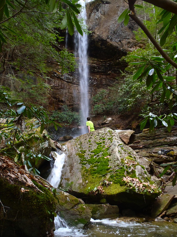 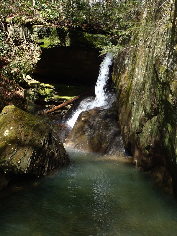 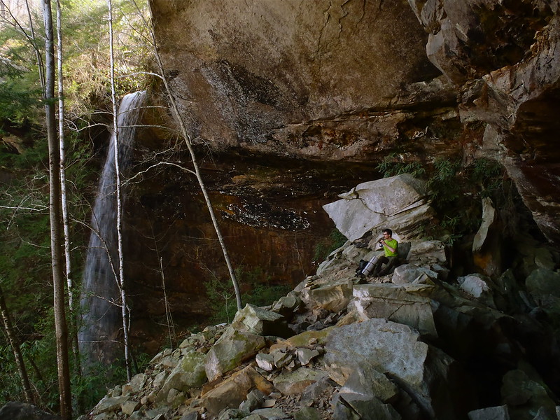 Happy hiking! |
|
|
|
Post by ashepabst on Jan 25, 2017 14:31:41 GMT -8
that's awesome --thanks so much for the info. I do believe you just planned my next Cumberland hike.
|
|
|
|
Post by markweth on Jan 25, 2017 14:54:34 GMT -8
You're welcome.
I'd definitely recommend going in March or April, especially after a few days of rain (our trip worked out perfectly that way). The waterfalls aren't as impressive unless there is a good bit of water and the ticks in the BSF can be pretty bad during the summer. Spring wildflowers and trips to these waterfalls is pretty hard to beat, add in the off-trail arches and it's pretty stellar!
I'd recommend bring trekking poles and dedicated wading shoes, especially for Tackett Creek.
|
|
|
|
Post by ashepabst on Jan 26, 2017 6:44:55 GMT -8
yeah, I tend to confine my Cumberland hiking to the leaf-off months when water tables are higher. hopefully I can get away for a trip next month after work slows down. I have a horror story involving Big South Fork and 100+ seed ticks, and me walking out in the dark. worst backpack attempt ever  |
|
driftwoody
Trail Wise!
Take the path closer to the edge, especially if less traveled
Posts: 14,974
|
Post by driftwoody on Jan 26, 2017 7:50:30 GMT -8
You're welcome. I'd definitely recommend going in March or April, especially after a few days of rain (our trip worked out perfectly that way). The waterfalls aren't as impressive unless there is a good bit of water and the ticks in the BSF can be pretty bad during the summer. Spring wildflowers and trips to these waterfalls is pretty hard to beat, add in the off-trail arches and it's pretty stellar! I'd recommend bring trekking poles and dedicated wading shoes, especially for Tackett Creek. For my trip to Tacket Creek in March I will bring some sturdy Teva sandals for crossings, but I'm considering another option for Laurel Fork with its 18 crossings. I have a pair of 5-10 Water Tennies I wore with neoprene socks for a 7 hour day hike in the Zion Narrows. This combination worked quite well over wet rocks in cool water. However, after being immersed in water during most of that rocky hike the next day my feet were too swolen for my regular hiking boots. I'm conerned this footwear combination might have a similar effect during the 3 day 20 mile Laurel Fork loop I'm planning. The difference is I won't be in the water all day. I always use trekking poles when backpacking. |
|
|
|
Post by markweth on Jan 26, 2017 8:37:06 GMT -8
Tackett Creek is less about the crossings, to be honest, and more about being willing to wade in ankle to shin deep water and scramble around on some boulders to check out the different waterfalls. Then just turning around when you're "done" and hiking back to where you stashed your pack.
I think that switching your footwear for the hikes would make the most sense . . . take the Tevas for the crossings on Laurel Fork and use the water tennies for Tackett Creek.
|
|
FamilySherpa
Trail Wise!
Tangled up in Rhododendron
Posts: 1,791
|
Post by FamilySherpa on Jan 26, 2017 8:54:26 GMT -8
I have a horror story involving Big South Fork and 100+ seed ticks, and me walking out in the dark. worst backpack attempt ever  |
|
driftwoody
Trail Wise!
Take the path closer to the edge, especially if less traveled
Posts: 14,974
|
Post by driftwoody on Jan 26, 2017 10:41:57 GMT -8
A few pictures, taken in mid-March 2012 on the streams discussed above: Nice pics, thanks for sharing. Which of those are from Anderson Branch? If I only have the time or energy to do just one it seems like Tacket is the better choice. Also, looking at the map, I see that NB Creek continues west beyond the trails and branches off into a few other tributaries. Have explored NB Creek west of the JMT? I think that switching your footwear for the hikes would make the most sense . . . take the Tevas for the crossings on Laurel Fork and use the water tennies for Tackett Creek. Thanks for the advice, I can see how it would make sense to keep the Water Tennies on for off-trail wet scrambles. On the longer Laurel Fork hike I'll stick with my regular boots (Ahnu Coburn) and switch to the Teva sandals when fording the creek above boot-top level. With that many crossings it will be time consuming, but I've given myself plenty of time for that hike and will be in no hurry. |
|
|
|
Post by markweth on Jan 26, 2017 12:52:41 GMT -8
You're welcome. I was debating whether or not to post pictures as I didn't want to spoil the surprise. The first and last pictures are from Anderson Branch and are of the "main attraction" that is at the head of the creek. It is a place you will definitely want to spend time at once you get there. The waterfall is absolutely mesmerizing and it feels like you have a rugged piece of paradise all to yourself.
The middle picture is from Tackett Creek and is of a waterfall that a friend and I turned around at on our first trip up there. There is another waterfall downstream from it that you pass on your way up; above it the creek is flowing over bedrock (slippery!) at a decent gradient before reaching a boulder jumble, above which lies this waterfall. That's what I thought was cool about Tackett Creek . . . from its mouth it looks like a non-descript, normal Cumberland Plateau stream, then it hits a waterfall, changes character above the waterfall, changes character again when it hits the boulder jumble you scramble through, and then hits another waterfall.
I would really recommend exploring up both if you can and wouldn't really suggest one over the other in terms of scenery, both have different charms. Tackett Creek is definitely more of a scrambling, immersive/enchanting, in-the-creek type of experience, whereas Anderson Cave Branch is more of a "choose the best path" to get to the highlight at the end. So picking between the two will really depend more what type of experience you're after.
|
|
|
|
Post by ashepabst on Jan 29, 2017 14:00:16 GMT -8
ha, well i gave away the ending in my summary. i feel like surely you guys have heard this story at least twice. anyway, i think i got them all off. no known tick diseases to report. |
|
driftwoody
Trail Wise!
Take the path closer to the edge, especially if less traveled
Posts: 14,974
|
Post by driftwoody on Jan 29, 2017 16:53:38 GMT -8
markweth, is there anything visible remaining of Terry Cemetery on the trail to the west of Maude's Crack?
|
|
|
|
Post by ashepabst on Jan 30, 2017 7:51:28 GMT -8
the cemetery's still maintained and right on the road. if I remember correctly it's right at the trailhead for the trail to the Crack, and the Longfield Branch Trail.... or very near by if not.
|
|
|
|
Post by ashepabst on Jan 30, 2017 7:56:25 GMT -8
...one of the Slaven tombstones was the last resident of the Gorge.
|
|
 Image Credit / Coolkat


