

Mt Monadnock (New Hampshire, Nov/23/2022)
Nov 28, 2022 11:38:18 GMT -8
panatomicx, absarokanaut, and 3 more like this
Post by GaliWalker on Nov 28, 2022 11:38:18 GMT -8
The day before Thanksgiving, I did my (by now) traditional hike up Mt Monadnock, in southern New Hampshire. This was my 8th time in the past 9yrs; 2020 was skipped due to the pandemic.
I reached the Monadnock State Park headquarters parking lot at 6:20am. This early in the morning mine was the first car there. The temperature gauge read 25°F, but it didn't feel that bad, possibly because it wasn't that windy. From experience I knew that both of these two things would change when I gained the open slopes atop the mountain.
I was on my way up the White Dot Trail by 6:30am. It was just bright enough for me to not have to use a headlamp. In the past I'd always just taken the steep, but short, White Dot Trail to the summit. This time, for variety, I branched off onto the Cascade Link trail after 0.8mi. The Cascade Link trail meandered for a bit through flattish forest before the gradient increased significantly, as I side-hilled across a steep slope. A series of short scrambles over ledges, and corridors of up-sloping rock slabs led me out of the woods, where I was treated to a nice sunrise. Not long afterwards I reached the northeast ridge, and the Pumpelly Trail.

Breaking out into the open

Sunrise
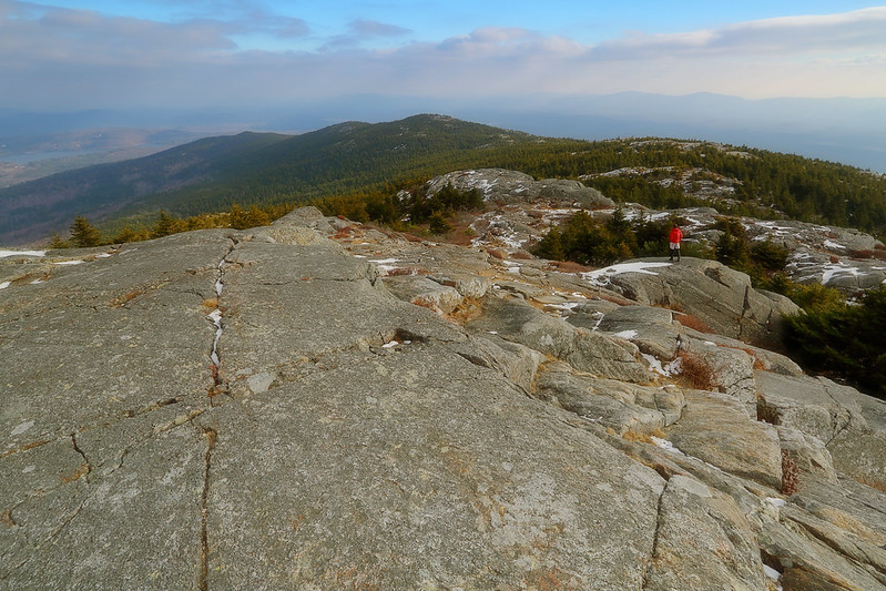
Hiking the rollercoaster Pumpelly Trail was to be the highlight of this particular trip. On past trips, the northeast ridge had always intrigued me. The one time I'd previously tried to hike it, I'd been unable to find a parking spot at its base due to deep snow, so abandoned my attempt. This time, while I was only going to hike up half its length, it promised to be the best part of the trail, because I'd be mostly out in the open, with views in all directions.
As soon as I hit the northeast ridge I was blasted by a freezing cold wind. I don't think the upper slopes of Mt Monadnock are ever calm. I put on microspikes due to some icy patches. I don't think the microspikes were particularly necessary, but I'd have felt pretty silly if I'd slipped, with them tucked away in my backpack. In 0.4mi, I rolled over the summit of Town Line Peak, which featured great views down the northeast ridge, as well as up towards the summit. As I continued climbing, the trail weaved its way through the occasional section of woods, but mostly stayed atop open granite slabs, with cairns marking the way. The hiking was sublime all the way to the summit.

Town Line Peak view of the northeast ridge

Town Line Peak view of the summit

Sublime slabs

Somewhat icy

Town Line Peak
Northeast ridge (selfie)

Summit
From the summit I dropped down the White Dot Trail to its junction with the White Cross Trail. After only a few dozen yards on this I turned right onto the Smith Connector. I took the latter down to Bald Rock, which featured fine 360° views, and its junction with the Cliff Walk trail.

Skylined (selfie)

The summit from Bald Rock

Bald Rock views
I continued to drop down steeply, through dark forest, until I reached the junction with the Lost Farm Trail, onto which I turned. The Lost Farm Trail featured a carpet of ankle-deep leaves. Swishing through these was an enjoyable, albeit slippery, affair. I closed my loop with a short stretch on the Parker Trail.

Lost Farm Trail views
Hiking/Photography stats: 6.5mi, 2800ft elevation gain, 6.25hrs
I reached the Monadnock State Park headquarters parking lot at 6:20am. This early in the morning mine was the first car there. The temperature gauge read 25°F, but it didn't feel that bad, possibly because it wasn't that windy. From experience I knew that both of these two things would change when I gained the open slopes atop the mountain.
I was on my way up the White Dot Trail by 6:30am. It was just bright enough for me to not have to use a headlamp. In the past I'd always just taken the steep, but short, White Dot Trail to the summit. This time, for variety, I branched off onto the Cascade Link trail after 0.8mi. The Cascade Link trail meandered for a bit through flattish forest before the gradient increased significantly, as I side-hilled across a steep slope. A series of short scrambles over ledges, and corridors of up-sloping rock slabs led me out of the woods, where I was treated to a nice sunrise. Not long afterwards I reached the northeast ridge, and the Pumpelly Trail.
Breaking out into the open
Sunrise
Hiking the rollercoaster Pumpelly Trail was to be the highlight of this particular trip. On past trips, the northeast ridge had always intrigued me. The one time I'd previously tried to hike it, I'd been unable to find a parking spot at its base due to deep snow, so abandoned my attempt. This time, while I was only going to hike up half its length, it promised to be the best part of the trail, because I'd be mostly out in the open, with views in all directions.
As soon as I hit the northeast ridge I was blasted by a freezing cold wind. I don't think the upper slopes of Mt Monadnock are ever calm. I put on microspikes due to some icy patches. I don't think the microspikes were particularly necessary, but I'd have felt pretty silly if I'd slipped, with them tucked away in my backpack. In 0.4mi, I rolled over the summit of Town Line Peak, which featured great views down the northeast ridge, as well as up towards the summit. As I continued climbing, the trail weaved its way through the occasional section of woods, but mostly stayed atop open granite slabs, with cairns marking the way. The hiking was sublime all the way to the summit.
Town Line Peak view of the northeast ridge
Town Line Peak view of the summit
Sublime slabs
Somewhat icy
Town Line Peak
Northeast ridge (selfie)
Summit
From the summit I dropped down the White Dot Trail to its junction with the White Cross Trail. After only a few dozen yards on this I turned right onto the Smith Connector. I took the latter down to Bald Rock, which featured fine 360° views, and its junction with the Cliff Walk trail.
Skylined (selfie)
The summit from Bald Rock
Bald Rock views
I continued to drop down steeply, through dark forest, until I reached the junction with the Lost Farm Trail, onto which I turned. The Lost Farm Trail featured a carpet of ankle-deep leaves. Swishing through these was an enjoyable, albeit slippery, affair. I closed my loop with a short stretch on the Parker Trail.
Lost Farm Trail views
Hiking/Photography stats: 6.5mi, 2800ft elevation gain, 6.25hrs
