|
|
Post by absarokanaut on Mar 28, 2020 11:35:54 GMT -8
|
|
davesenesac
Trail Wise!
Our precious life is short within eternity, don't waste it!
Posts: 1,710 
|
Post by davesenesac on Mar 28, 2020 12:04:13 GMT -8
Quite enjoyed your stories balzacom especially the bear stories, well done, thank you.
A key reason I've been writing logs of some of my trip for decades is that together with images, that allows recalling events that are otherwise impossible to recall as time diminishes memory. Those memories are still there to some extent but need help to refocus on in our minds. Of the chronicles I've been writing over the last 5 years, they will be important sources I can display directly when I begin to publicly exhibit again speaking to audiences using large 8k display systems and multi-media.
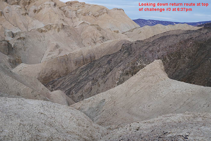
March 19, 2016 was a most interesting day of adventure for me at Death Valley National Park during its superbloom that starts at Black Mountains badlands adventure.
www.davidsenesac.com/2016_Trip_Chronicles/winter_2016-5.html#mar19
Topo for that bizarre confusing area (copy paste URL that forum software mutilated):
|
|
balzaccom
Trail Wise!
Waiting for spring...
Posts: 4,475
|
Post by balzaccom on Mar 28, 2020 14:41:04 GMT -8
Thanks David--both for the kind words and the contribution to our list of stories.
|
|
balzaccom
Trail Wise!
Waiting for spring...
Posts: 4,475
|
Post by balzaccom on Mar 29, 2020 11:11:34 GMT -8
One more from my end:
This happened years ago, when we were looking for some new places to fish. We had our regular trips to our favorite lakes, but this time we had decided that we were going to try something new. We talked to some people who had told us good things about Hyatt Lake, and I called a couple of guys I knew.
One of them told us how to get there. He said it was a bit of a bushwhack, but that they did it over a weekend, and it worked out fine. Even sent me a topo map with their route inked in.
The trailhead itself was a bit of a drive, about 45 minutes from the highway. And you started on a nice paved road, and then it became a rougher road, and then one lane. And by the time you got to the trailhead, you were bouncing a long a dirt road for a mile or two.
There was a sign at the trailhead, but that was about it. There really wasn’t a trail. It’s what the forest service calls a “route.” That means people walk it, you can find a way to get there, but there are no sign and they don’t do any maintenance on it.
At first it was easy to follow, just running up and along a ridge for a while, and then it broke out onto the other side of the ridge. This is that area above Cherry Creek, where it’s pretty much all granite and not much else. And the route went down across that granite somehow.
So I led the way down, and every once in a while we’d see a cairn, but it wasn’t like they were really marketing anything. And you didn’t really need anything. This was an open granite slope that led down to the creek. So we just went down to the creek across the granite.
If it had been earlier in the season, crossing the creek might have been a problem, but we were later in the summer, and it was easy just to step across it. It was really just a series of pools connected by a trickle, but I did see a few trout, so that was a good sign.
So once we got across the creek, we were supposed to head up the canyon to a saddle on the righthand side. If you stayed down below by the creek, you were weaving and pushing through a bunch of alders, and you know what that’s like.
But if you went up on the side of the canyon there were big slabs of granite. That worked great until you got to where one of them stopped and the next one started—because that was always chock full of manzanita and a real mess.
But anyway, that’s what bushwhacking is like.
We made it up to where we could turn off and head up into the saddle. That was a cakewalk, right up the granite, and we popped out on the top of the ridge above Cherry Creek. The whole damn creek below us. You could see for miles.
And this is where it got interesting. The map said that we should work our way along the Cherry Creek side of the ridge, heading towards the outlet stream from Hyatt Lake. On the map it looked easy.
From the ridge, it looked really complicated. This was steep country, and I didn’t really see how we could do it. From the top of the ridge, there was really only one way you could go in that direction, so that’s what we did.
And for the next mile or so, we followed that track. Every time it got difficult, there was only one way to go, and so we went that way. I kept expecting it to peter out, or leave us cliffed out, but damn if that series of ledges above the outlet stream took us right down to cross that stream about a quarter of mile below Hyatt Lake. The last thirty feet were pretty steep, twisting down a gully, but it was also clearly what other people had done.
We were damn happy to see that.
And from there, I just looked at the map and said, “Perfect. I know right where we are. We don’t need this map anymore. Let’s just follow this stream up to the lake.”
The streambed was pretty much dry, so that’s what we did. And then we got to a big pool that was basically a bay in Hyatt Lake. It was pretty deep, right up to the shore. On the right hand side there were some very steep cliffs about forty feet high, so we knew we couldn’t go that way.
But on the left was an absolute manzanita mess—Just a solid wall of manzanita for half the length of the lake. Not what we were expecting. I mean, we were at the lake, but we still weren’t anywhere.
So we pushed on through the manzanita. I went first, looking for any kind of path, but my wife watched me, and decided that there had to be an easier way, so she went off in a slightly different direction.
The deeper I got into the manzanita, the worse it got. I was just pushing through that crap. I was maybe a hundred yards into it, and it had taken a good fifteen or twenty minutes to get there. And I could hear my wife somewhere behind me and above me, having exactly the same amount of fun.
And that’s when I hit the granite. A fin of granite came right down through the manzanita and blocked off any further progress. I tried for a couple of minutes, and there was no way to get past it. Going up looked worse, and so I slithered down through the manzanita towards the lake.
Over here it didn’t look that deep, maybe two feet at the most. So I wedged myself into the manzanita with both feet and one hand, and then took off my boots and put on my water sandals.
Once into the lake, it wasn’t too bad. I was worried that it might get deep, but if I stuck close to shore, I could walk past the whole wall of manzanita, and make it to the far shore, where there were trees and even a little grassy area. Which is what I did.
My whole body was scratched and itchy; full of manzanita debris, from leaves to branches, but I made it to the shore and dropped my pack.
That’s when I called out to my wife and told her what I had learned. I couldn’t see her; she was so deep in the manzanita. She grumbled and moaned, but then I could see some of the manzanita moving up above. And then slowly she came down to the lake, and got into the water.
I watched her for a few minutes, and then suggested that she should put on her water shoes, since that would make walking in the lake easier.
“I can’t,” she said. “I don’t know where they are.”
I told her they were strapped on the back of her pack.
“Not anymore!” she said with some vehemence. They had been torn off her back somewhere in the middle of the manzanita, and she had no idea where. They are probably still there, if someone want’s to go looking for them.
She eventually made it wading barefoot along the edge of the lake and joined me under the trees. We didn’t say much. We were both thinking that they must be a better way. In fact, there had to be a better way, or we were never going to get out of Hyatt Lake.
Of course, there was. Once we wandered around the lake and found a campsite, we explored a bit more and found a use trail to follow. It led back along the top of those granite cliffs that we had avoided. And right above the outlet stream, right across from where our incoming trail had led down that steep gully, it did the same on the other side. It dropped steeply down a crevice behind a granite wall, dropping us right into the outlet streambed.
Too bad we hadn’t seen that on the way in. But we didn’t bother to look, because I knew right where we were.
My wife still occasionally asks to take a look at the map, particularly when things are getting a little interesting. Just in case I think I know right where we are.
|
|
toejam
Trail Wise!
Hiking to raise awareness
Posts: 1,795
|
Post by toejam on Apr 4, 2020 14:30:43 GMT -8
Lottie Potrero Trail Part 1 There’s a remote, seldom-used, overgrown trail in the eastern part of the Silver Peak Wilderness called the Lottie Potrero Trail, named after a settler who homesteaded the potreros (grassy meadows suitable for grazing) along the ridge at the north end of the trail. It’s disappeared from many maps, like Nat Geo Trails Illustrated, for lack of use and intel. But the Forest Service still lists trail 7E01, Lottie Potrero Trail, as an official trail. I suspect they’ve just forgotten about it.  Over the years I’ve talked to several locals who said they’d like to look for the Lottie Potrero Trail. We’ve all heard stories of people hiking it years ago and the dense brush and poison oak they encountered. Access to the trail isn’t easy. It’s either several hours on 4x4 roads driving to the unsigned north end of the trail, or a seven-mile road walk from the coast that climbs 2000’, drops 1500’, goes through a gate at a Buddhist hermitage, and climbs another 600’ to the unsigned south end of the trail. The Lottie Potrero Trail is historically important because it’s presumed to be the route Gaspar de Portola and the Sacred Expedition took inland to avoid the steep slopes of the Big Sur coast, and was part of the trail between the Indian settlement at the mouth of San Carpoforo Creek and Mission San Antonio de Padua. It’s on all the historic USGS and forest maps. The southern half of the trail is not actually forest land because of old homestead inholdings and it passes a few old cabins, besides the Baldwin Ranch hermitage. Last year I drove to the north end of the trail. There was no evidence of a trail along the road, but we followed a gps track on a phone screen down a grassy slope and found some small cairns, old faded pieces of flagging, and a faint tread. We also found two hikers on the road headed for the Lottie Potrero Trail as part of a long loop hike. They’d already made an ignorant mistake with the gps on their phones that cost them a punishing bushwhack that day, so we told them we thought Lottie Potrero Trail was not a good idea. More people are visiting the Silver Peak Wilderness these days. Several issues limit access to trails in the larger and more popular Ventana Wilderness to the north right now, so many hikers, and also trail crews, have spent more time in the Silver Peak Wilderness. With the trails in better condition people are hiking further from the popular trailheads. If you didn’t know better, Lottie Potrero Trail looks like a viable loop opportunity on the map. I decided to try to clear the trail before someone gets lost or hurt and needs to be rescued. On MLK weekend I did the long hike with big climbs to the south end of the trail. By 11:00 I’d negotiated ranch roads until one of them turned into an overgrown trail and my gps file said this was the right spot. The brush was too thick to just push through with a full backpack, so I used a good pair of loppers and a large hand saw to clear a path for upright walking. There was quite a bit of poison oak growing alongside the tread, but it wasn’t bad yet in January. My handiwork:  I cut brush continuously for five hours and worked my way about 0.7 miles to a flat grassy spot at the mouth of Davis Canyon (Devil’s Canyon on every map before 1966). My progress was celebrated with a campfire and tunes on my new sopranino ukulele. In the morning I explored further. The trail follows a creek bottom choked with poison oak and is lost to overgrowth, blowdowns, and crisscrossing game trails. A half mile further there is a cleared pasture and an old cabin, and the trail follows the fork in the creek to the left, disappearing into the brush on its way to the ridge two miles and 1200’ above. I explored the cabin and hiked back to the coast, doing a little more clearing and thinking there wasn’t that much more work to do before this trail looked like a trail again. Faint trail along Creek:  Cabin and cleared pasture:   |
|
daveg
Trail Wise!
Michigan
Posts: 565
|
Post by daveg on Apr 4, 2020 15:40:17 GMT -8
Murphy
I first met Murphy in Duncannon, Pennsylvania, while eating dinner at the Doyle Hotel, a legendary stop for Appalachian Trail hikers. The century old structure shows every year of its age, but compared to life on the trail, it offers luxury accommodations -- hot food, cold beer, inside plumbing, chairs with backs, beds with linens, and private rooms. Its owners were welcoming and the patrons were sociable.
One of those patrons was Murphy, a southbound thru-hiker. He had started his hike three months before and over 1,000 miles away in Maine, at the northern terminus of the AT.
At first glance, Murphy was a clone of many other thru-hikers I have met – skinny, bearded, half my age, nice, gregarious. But then I noticed his prostheses. Both of Murphy’s legs ended at his ankles. He had prosthetic feet which were attached to his body by sockets that encapsulated his shins.
Hiking the Appalachian Trail is not as difficult as some make it out to be, but neither is it easy. The northern half – the part Murphy had already completed – contains the most rugged terrain, including Baxter Peak (Katahdin) and the Mahoosuc Range in Maine, the White Mountains in New Hampshire, and the Pennsylvania rocks.
Murphy had started with some spare parts for his prostheses but had used them all up less than 50 miles into his hike, forcing a three day break at White House Landing while replacements were shipped in. He had fallen in every one of the eight states he had passed through so far.
In northern Pennsylvania, one of his prosthetic feet had broken several miles past a road crossing. Murphy had the parts necessary to fix it, but not the tools. After caching his backpack, he hobbled back to the road, removed his damaged prosthetic limb, and tried to flag down a passing motorist by waving it in the air.
Car after car zipped by without even slowing down. Eventually, an elderly woman stopped. Murphy explained his dilemma but she did not have any tools in her car. “I passed a road construction crew a couple miles back,” she said. “I’ll go see if they can help.”
She turned her car around and drove away, leaving Murphy to wait on the side of the road. He sat there a long time and was getting really discouraged when, finally, one of the road crew’s trucks pulled up. “A lady told us there was a guy down the road with a broken leg and he needed a pair of pliers to fix it,” the driver explained. “That didn’t make any sense but we figured we’d better check it out.”
The road crew had the necessary tools and, after repairing Murphy’s foot, he continued on his way.
|
|
balzaccom
Trail Wise!
Waiting for spring...
Posts: 4,475
|
Post by balzaccom on Apr 4, 2020 20:21:13 GMT -8
Nice! That one made me chuckle!
|
|
toejam
Trail Wise!
Hiking to raise awareness
Posts: 1,795
|
Post by toejam on Apr 5, 2020 6:08:50 GMT -8
Lottie Potrero Trail Part 2 Two hardy hiking buddies were interested in going back to work on the Lottie Potrero Trail on the next long weekend. I wanted to get back there before the poison oak had a good chance to grow. We met after work Friday evening and hiked by headlamp to cowboy camp on top of the first ridge. The next day we hiked to the Lottie Potrero Trail. Morning at cowboy camp  I borrowed a 48” crosscut saw so we could get some big logs off the trail, and we cut five in the first section. There was evidence of an unknown person having cut a little brush since I’d been there - they left cuttings in the trail, which I don’t do. We struggled through the overgrown creek bottom past Davis Canyon, finding no reasonable path to clear, and left our camping gear in the meadow near the cabin. Then we worked on the first 0.6 miles of the trail beyond the cabin before running out of time and energy.  In the morning one of the guys needed to hike out, so we went back as far as Davis Canyon with him and spent the morning trying to clear and flag a path out of the worst poison oak in the creek bottom section. After lunch the other guy and I pushed on up the trail. We hiked the section cleared the day before, then battled unrelentingly tight chaparral for about a mile, often on hands and knees with leafless poison oak stems in our faces. There were old cuts and the faintest tread apparent most of the way, but we had to reference the gps track often and reached the ridge two miles above our camp after 3 and a half hours.   Slow progress and limited daylight meant we didn’t get to clear the trail but cut only what was necessary to push through dragging our backpacks, a 4’ saw, and an ax. We only left a few pieces of flagging tape because our route was uncertain, but we did locate, clear, and cairn the top of the trail by the road. Lottie Woodworth homestead site  Cairned trail from South Coast Ridge Road  Our plan was to hike another 6 miles to one of our favorite camps. But the bushwhack was exhausting and walking the ridge road was harder than expected with all the ups and downs. We deviated from the plan and stopped at the first water source for the night and tried to wash off the poison oak. I tried to get back there a few weeks later to camp at the north end of the trail and work down. But rain on the 4x4 road and an injured knee stopped me. I think I can responsibly stay socially distant at this remote place, so maybe I’ll get back again soon. |
|
davesenesac
Trail Wise!
Our precious life is short within eternity, don't waste it!
Posts: 1,710
|
Post by davesenesac on Apr 5, 2020 10:34:02 GMT -8
The following autumn fishing tale is taken from the below link with more pictures.
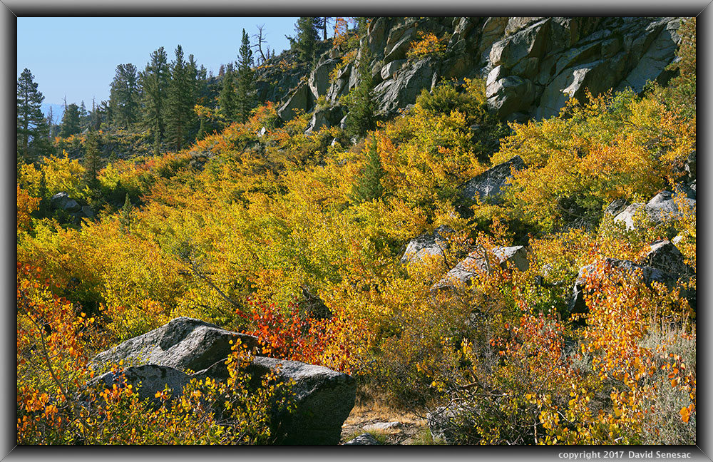
As dawn broke on Friday September 29 we were slow to get up because the temperature was now a cold 28F. But not long after the high peaks to the west showed warm light, we got out all bundled up and then set about heating water for hot chocolates. Just east the canyon walls of Table Mountain rise up steeply, so sunlight takes awhile to arrive beyond sunrise. By 8am breakfast was over so we drove up the gravel North Lake Road that receives shining warming sun earlier. Its aspen groves were still mostly just lime green with bits of yellow or at least a week away from being interesting. Accordingly there were few photographers about and rather just a dozen fisher people scattered about the small lake's shores. I introduced Joe to North Lake and as we left at 9:15am, shot the above 3 stitch panorama of fire on the mountain that I hoped to return to Saturday morning for a longer session. Notice shadows on boulders that indicate the sun somewhat back lit position above to the left. Leaf color and vibrancy on trees like this are highly dependent on time of day and lens shooting directions.
But today would be all about fishing as we then drove to Lake Sabrina, a reservoir, then hiked along the good trail along the steep north shore. Joe caught a nice 11 inch rainbow and a couple smaller fish and David one small fish but after a few hours still did not have much of a meal for the two of us. Then a bit after 12 noon, using the smallest 1/12 ounce silver Kastmaster connected into a large trout that immediately was zipping out line as I loosened drag. The big fish jumped totally out of the water and continued to make run after run for some time before eventually tiring and being landed into Joe's net. The trout was 18 inches long with a broad salmon like body and typical orange mature salmonid flesh.
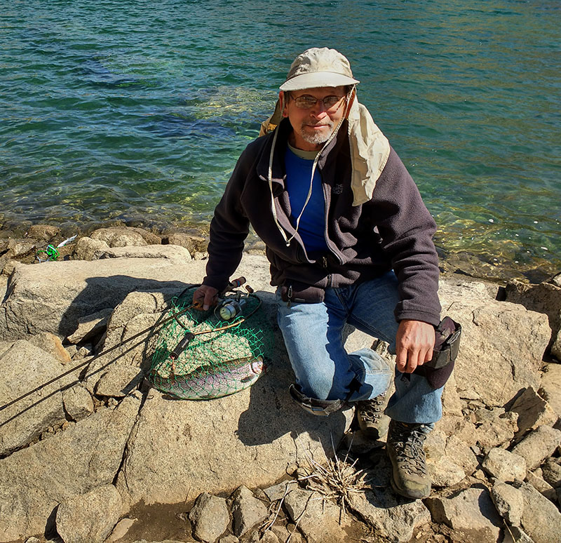
Joe took a quick picture with my cellphone. I did not waste time dispatching the two fish, then cleaning them. I greatly dislike having to kill any larger creatures including fish. However as someone that regularly eats minor amounts of meat including occasional burgers, chicken, and fish, believe having to infrequently end the life of creatures we will eat gives a person more respect for what we humans are doing. In this era people are vastly detached from what our ancestors had to do daily as organic creatures on this planet eating other creatures. Within a half hour we were back at camp and began making our big lunch feast. Joe is more a fisherman and cook than I am so he worked frying the fish in a frying pan while I cooked the rice in a pot.
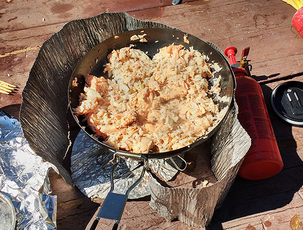
We usually remove the head, scales and tail during cleaning and then the skin, fins, and bones during cooking after a fish is nearly cooked. Then will combine broken up fish flesh mixed in with rice that we go through a couple more pan heating sessions with. With so much fish flesh, we divided the mixing into our two frying pans, one pan of which is above. I could barely eat it all. What a delicious meal!
|
|
|
|
Post by absarokanaut on Apr 5, 2020 11:00:26 GMT -8
Awesome stuff gentlemen!
|
|
gabby
Trail Wise!
Posts: 4,537
|
Post by gabby on Apr 5, 2020 12:58:25 GMT -8
|
|
balzaccom
Trail Wise!
Waiting for spring...
Posts: 4,475
|
Post by balzaccom on Apr 5, 2020 21:05:36 GMT -8
Hi Gabby That was a trip report over there. I post those on a few different sites--and posted it here, too, back then. If you check the date, it's pretty old. But yes, that's same trip. What I'm doing with the Tales of the Tentcamperon is trying to put together a selection of camping stories--so not really trip reports. Still, if you really want to read everything, you should check out our website: sites.google.com/site/backpackthesierra/homeWay more than you'd ever want to know....grin |
|
gabby
Trail Wise!
Posts: 4,537
|
Post by gabby on Apr 5, 2020 22:39:50 GMT -8
What I'm doing with the Tales of the Tentcamperon is trying to put together a selection of camping stories--so not really trip reports. I'm a relatively bad writer, so presume I read just as badly: I drift and wander too much when writing; I suspect I do much the same reading. It was interesting reading both versions of the story to see the slight difference in perspective, and, also, reading both seemed to bring out some depth, as if seeing the same view from two angles. The pictures definitely helped with that. I get that you're going for something different here, but I'm not, generally, as intuitive or perceptive - perhaps one of those is the word I'm looking for here - as most, so I miss the connection if it's not "literal". It's a good idea, your Tentcamperon. I get the primary impetus, I guess. I once had a volume of stories - I now forget the title (where did it go?) - which was driven by the idea of taking the same story and casting it into different genre: as a mystery, or, perhaps, as a romance, then a gothic horror - and many others. So, a trip report as a story told by a group huddling (electronically, in our case) in a foreign place to avoid the plague? Yes, and then they could be cast as stories told by a group to pass time on a pilgrimage. A set of Camperbury Tales sort of thing, I guess. |
|
balzaccom
Trail Wise!
Waiting for spring...
Posts: 4,475
|
Post by balzaccom on Apr 6, 2020 6:06:03 GMT -8
'Yes, and then they could be cast as stories told by a group to pass time on a pilgrimage. A set of Camperbury Tales sort of thing, I guess.
I Love IT!! |
|
|
|
Post by absarokanaut on Apr 6, 2020 11:05:22 GMT -8
As a high school senior, through much of college, and then again in my 40s I was fortunate to work warmer months for my cousin on and off the wonderful Guest Ranch in Northwest Wyoming that he's owned with his wife and now adult children for almost 40 years. There, not far Southeast of the Continental Divide, just above the Sage Steppe country of the Absaroka Foothills, massive remnants from eruptions of the Yellowstone Caldera rise as towering precipices that rim the "true" headwaters country of the Wind River. These mountains are made mostly of rotten conglomerate and are quite the contrast to the more gently sloping and granitic Northeastern Wind River Range to the South. Many of my chores across this amazing section of land and adjacent National Forest often afforded simultaneously neck wrenching and jaw dropping views of several rugged summits, an often jagged wall of sorts guarding the Southeastern entrance of the 48 states remotest wilds. Although overshadowed by the nearby Western Wind River and Teton Ranges it's not terribly difficult to understand why this country is part of the world's first National Forest, your 2.4 million acre Shoshone.
The Ranch is not huge, just under 650 acres, but being able to dissapear into thousands of spectacular acres in the adjacent Shoshone remains a gift I treasure reliving often. The Ranch's "capacity" is quite small, normally under 20 people. A couple of years before I moved across the Continental Divide to the Jackson, WY area, in 2010, we made the successful transition from a family destination to one for group workshops, retreats, etc. It allowed for a much smaller staff, and a few breaks of multiple days that we hardly ever enjoyed under the family model. By this time I had hiked many of our area summits, but because of accesibility and caution of doing a solo overnight in such dense grizzly habitat I had never been able to hike to the top of the Ramshorn Plateau from the West side, just East of the Ranch. That July with a nice 3 day break starting the 31st my cousin, our Top Hand/head outfitter, and a former guest that now owned an area property and his teenage son and one of his friends set out on an overnight horse packtrip to an idyllic meadow right underneath the jaw dropping cliffs of the one of the peaks that define the western edge of the plateau. The 3 of us from the Ranch had been here before and I had hiked well above the meadow to about 11,000' in the cirque above, but none of us had crested the plateau from this western side. My cousin and the old guest and new neighbor wanted to ascend the one peak that has a relatively unobstructed view of their properties. I could see they were going to run into a seemingly impenetrable cliff ban near the summit and wanting to get on top I had my eyes set on a very steep bouldered slope at the head of that cirque. Having gotten to the bottom of the "nearly" vertical slope in years past I was pretty confident it was the only 4th class route to the top in the area.
The ride in was uneventful aside from necessary brush, limb, and log clearing on the sometimes trailed route to the pulchritudinous "park" where we would spend the night. We had two pack horses with all our gear and food backpackers only dream of. The 7-8 mile ride took about 3 hours so to set up camp in our sensational setting about 2,500' above the Ranch inside the more than 700,000 acre Washakie Wilderness. After setting up camp I took a late afternoon hike to a spectacular outcropping I'd never been up before. It was steep and rugged, and I broke one of my high dollar trekking poles on my descent. As dissapointing as the loss was I knew REI would replace the pole, knowing I would be using my hands more than anything else to get up and hopefully out of the cirque the next morning. Since I'd most likely be riding back to the Ranch I was not terribly worried about having only one pole for the remainder of the trip. I am a fairly broad and heavy guy and this was the second trekking pole I'd collapsed and after collapsing a third pole I don't use trekking poles anymore, I now have a set of old ski poles I've reinforced a bit that haven't broken for almost 10 years now.
After my hike, from what I recall all these years later, we had a fabulos dutch oven fried chicken dinner with mashed potatoes, corn on the cobb, green beans, and some delicous rasberry cobler. I had seen multiple fresh grizzly tracks on my hike and knowing these bears to some degree we had a raging fire going by mid evening. As an unbelievable canopy of stars unfolded above us I had my second beer. I drink a lot of beer at times but knowing the task ahead of me the following morning I made my way to my North Face Pebble and got to sleep fairly quickly. Around 01:00AM our horses started making a lot of noise and my cousin heard crashing through nearby willows. The following morining we confirmed our suspicions with the tracks of a medium sized grizzly not 20 yards from some of our tents. Thirty years earlier as a young horse packer in the Absaroka I would have been sleeping right under the cook fly, but with the growth of the Greater Yellowstone grizzly population over the years we had of course become far more cautious. My now years long paranoia of solo camping up there had been validated to say the least. We got back to sleep and I slept in a bit to about 06:30AM.
I am not a coffee drinker and don't linger over breakfast. I was and remain a much slower hiker than my long legged and skinnier cousin; so I set out about 07:00, perhaps a half hour or so before my cousin and our old guest began their hike. Our Top Hand remained in camp and the two boys slept in and would spend the day far less ambitiously in and around camp. The plan was to be back at camp by 2:00PM so we could get back to the Ranch for a delicious dinner. About 15 minutes after leaving camp I ran into a large bull elk and walked over fresh bear tracks for perhaps 10 minutes or so. I made my way up the trail and into the cirque. It was the first of August and we'd had a very light frost over night; but the flowers in the cirque were wonderful and after rising above the krumholz I had that frequent feeling of darn near hearing Julie Andrews singing. After an hour of hiking I was at the bottom of my steep boulder slope so I sat down for a quick rest and gaze of the ground I'd already covered. I saw my cousin and the old guest break out above the krumholz and make the turn to the North for their desired summit. I soon began pushing and pulling myself up the imposing slope. I was almost 47 at the time and had not done an ascent nearly as extreme as this one in many years. When catching my breath I would turn to see the progress of the other two hikers and was a bit dejected given that they seemed to be overtaking my progress despite their much later start. About 40 minutes into this climb that was far beyond a simple scramble I saw my first little trail of bighorn sheep scat so I knew I could make it if I summoned my best from within me. That's exactly what I did and with the greatest upper body workout I had had in years I found myself in the saddle between the daunting 11,635' pinnacle summit of Ramshorn Peak on my right and the far more benign 11,894' highpoint of the Ramshorn Plateau to my left. I had hiked to the base of the 80' pinnacle of the peak from Burroughs Creek on the East side of the plateau a few years earlier so after a 10 minute rest I took off to the left and began the marvelous 15 or so minute rise to Point 11,894'.
As I made the delightful ascent I stopped frequently taking in the expansive views of much of the southern half of Greater Yellowstone. Up there the most sensational of smiles came upon my face as I was enthralled by every direction I gazed. The ranges put the kind of spell on me I'd enjoyed just a handful of times over my years of wandering the Rockies from the Gila to Bozeman. To the West were the lovely Leidy Highlands,towering Tetons, glorious Gros Ventre, and alluring Absaroka Range west of the Continental Divide in the more than 585,000 acre Teton Wilderness of the 3.4 million acre Bridger-Teton National Forest. To the south the glaciers and peaks of the wondrous Wind River Range lit up the mid morning mostly azure sky. To the North and East the awesome Absaroka, the largest subrange of the Rockies, unfolded in a showcase of my favorite region on earth that is forever seared in my memory. From the remotest mountains of counterminious America, Younts Peak and Thorofare Mountain, to the Washakie Needles just shy of the Wind River Indian Resrvation's boundary I saw many places I had and had not been. Double Cabin and the rugged peaks above the Horse Creek Drainage occupied me to the right while the length of the Dunoir Valley, home to the Ranch, dominated the view below to my left.
When I reached the summit I dropped my pack, caught my breath, and popped open my cermonial can of my favorite beer, Bud Light. With my panting subsided I got out my camera and took dozens of photographs of the 360* view of millions of acres of one of the planet's absolutely most remarkable landscapes. I was proud of myself and lingered for almost an hour, glassing distant bighorn sheep on ridgetops and elk in meadows far below before heading back to the slot on the ridge line to descend that bouldered slope that took everything I'd had to get up. I knew it would be slow going down, but was confident I would make our 2:00PM rendezvous about two and a half hours later. I struggled, and about 200 vertical feet above the bottom of the bouldered nightmare my remaining trekking pole collapsed. I still had some treacherous descent to go and then the hike back to camp, so I got the cloth tape out of my first aid kit and taped it together at the highest level I could and then reinforced it with a little bailing wire and was on my way. When I got to the flowered covered bottom I couldn't get rid of my smile as I enjoyed the stroll back to the krumholz. Heading back to camp I decided to hike the opposite side of the creek that I never had before. Unfortunately I came to a point with a nearly 20' drop so I got my safety line out of my pack and put 3 50' lengths together to make it stronger. After lowering my pack I retrieved the line and looped it over a stout rock and safely made my way down the drop. It took a few swings but I was able to get the entire line and put it back in my pack. Twenty minutes later at 2:03 PM I was back in camp where everything aside from my own tent, sleeping pad, and bag had been broken down, packed, and loaded onto the pack horses. I learned that the cliff band had indeed stopped the ascent of my cousin and the old guest about 30' below their summit but they were elated with the view they had been able to get. I got my stuff together in just a few minutes and after showing photos to everyone else and jawing about what we'd done we were soon in the saddle and on our way.
Because of the exertion and physical contortions from the hike I got a bit sore towards the end of the 3 hour ride back to the Ranch. It was however a wonderful ride where we shared details from our separate hikes and bantered about the politics of the time and historical comparrisons of it. At the last closed gate I got off and opened it for everyone else and loosened my sinch and walked the 10 minutes or so to the pack shed where I helped the Top Hand unload the pack horses. I then made the 100' stroll to the paddock outside the tack shed and unsaddled my horse. After rewarding our mounts that had colled down with just a tiny bit of grain we then turned all the horses out to join their nearly 40 companions that had had the previous couple of days off. Before our delightful dinner I downloaded my photos and was more than simply pleased with some of them even if they could never convey the magnitude of the joy I'd experienced. I completed a route few if any ever had and stood on a summit that goes years without visitation. The hike ranked among the best I'd ever done in Wyoming and Colorado and above any other I'd done elsewhere among the continents. The season following this would be my last on the Ranch, but what I had come to call "The South Absaroka Wall" was cemented in my mind as the most spectaular region I had ever been. Although this hike is not practical for me these days I still enjoy a half dozen summits along this magnificent line of tremedous cliffs and narrow passes every summer. The southern Absaroka will almost certainly be my favorite place on earth when my time comes.
|
|
 Image Credit / Coolkat